

<< Our Photo Pages >> La Hougue des Platons - Chambered Tomb in Channel Islands and Isle of Man in Jersey
Submitted by Klingon on Monday, 10 July 2006 Page Views: 6315
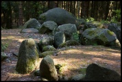
Neolithic and Bronze AgeSite Name: La Hougue des PlatonsCountry: Channel Islands and Isle of Man
NOTE: This site is 0.577 km away from the location you searched for.
Island: Jersey Type: Chambered Tomb
Latitude: 49.247720N Longitude: 2.100023W
Condition:
| 5 | Perfect |
| 4 | Almost Perfect |
| 3 | Reasonable but with some damage |
| 2 | Ruined but still recognisable as an ancient site |
| 1 | Pretty much destroyed, possibly visible as crop marks |
| 0 | No data. |
| -1 | Completely destroyed |
| 5 | Superb |
| 4 | Good |
| 3 | Ordinary |
| 2 | Not Good |
| 1 | Awful |
| 0 | No data. |
| 5 | Can be driven to, probably with disabled access |
| 4 | Short walk on a footpath |
| 3 | Requiring a bit more of a walk |
| 2 | A long walk |
| 1 | In the middle of nowhere, a nightmare to find |
| 0 | No data. |
| 5 | co-ordinates taken by GPS or official recorded co-ordinates |
| 4 | co-ordinates scaled from a detailed map |
| 3 | co-ordinates scaled from a bad map |
| 2 | co-ordinates of the nearest village |
| 1 | co-ordinates of the nearest town |
| 0 | no data |
Be the first person to rate this site - see the 'Contribute!' box in the right hand menu.
Internal Links:
External Links:
")
WV656556
You may be viewing yesterday's version of this page. To see the most up to date information please register for a free account.
")
")
")
")
")
")
Do not use the above information on other web sites or publications without permission of the contributor.
Click here to see more info for this site
Nearby sites
Click here to view sites on an interactive map of the areaKey: Red: member's photo, Blue: 3rd party photo, Yellow: other image, Green: no photo - please go there and take one, Grey: site destroyed
Download sites to:
KML (Google Earth)
GPX (GPS waypoints)
CSV (Garmin/Navman)
CSV (Excel)
To unlock full downloads you need to sign up as a Contributory Member. Otherwise downloads are limited to 50 sites.
Turn off the page maps and other distractions
Nearby sites listing. In the following links * = Image available
846m E 90° La Roche a la Fee* Cist
3.3km WSW 256° La Hougue Boëte* Chambered Tomb
4.9km ESE 108° Le Couperon* Passage Grave
5.9km SSE 154° La Hougue Bie* Chambered Tomb
6.1km SSW 201° Ville ès Nouaux* Burial Chamber or Dolmen
6.8km S 170° Les Varines* Ancient Village or Settlement
7.3km SE 133° Faldouet Dolmen* Burial Chamber or Dolmen
8.3km W 272° La Hougue des Géonnais* Passage Grave
8.4km SSE 166° Le Mont Ubé* Passage Grave
9.0km SSE 167° La Dame Blanche* Standing Stone (Menhir)
9.1km WSW 259° Les Mont de Grantez* Passage Grave
9.4km WSW 246° Les Trois Rocques* Standing Stones
9.5km WSW 244° The White Menhir Standing Stone (Menhir)
9.7km SSW 210° La Hougue de Vinde* Chambered Tomb
9.8km S 170° La Motte (Jersey)* Cist
9.9km SW 236° La Tête des Quennevais Ancient Village or Settlement
10.0km WSW 237° Broken Menhir, The* Standing Stone (Menhir)
10.1km WSW 237° The Ossuary* Chambered Tomb
10.2km WSW 237° Little Menhir, The* Standing Stone (Menhir)
10.2km W 274° Les Landes Cist* Cist
10.3km W 276° La Cotte a la Chevre* Cave or Rock Shelter
10.3km SW 219° La Cotte de St Brelade* Cave or Rock Shelter
10.3km SW 235° Great Menhir, The* Standing Stone (Menhir)
10.4km W 276° La Hougue des Grosnez* Round Barrow(s)
11.1km W 270° Le Pinacle* Rock Outcrop
View more nearby sites and additional images


 We would like to know more about this location. Please feel free to add a brief description and any relevant information in your own language.
 Wir möchten mehr über diese Stätte erfahren. Bitte zögern Sie nicht, eine kurze Beschreibung und relevante Informationen in Deutsch hinzuzufügen.
 Nous aimerions en savoir encore un peu sur les lieux. S'il vous plaît n'hesitez pas à ajouter une courte description et tous les renseignements pertinents dans votre propre langue.
 Quisieramos informarnos un poco más de las lugares. No dude en añadir una breve descripción y otros datos relevantes en su propio idioma.