

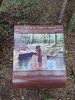
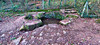
<< Our Photo Pages >> Ville Guichais menhir - Standing Stone (Menhir) in France in Bretagne:Ille-et-Vilaine (35)
Submitted by TheCaptain on Sunday, 19 December 2004 Page Views: 3085
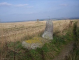
Neolithic and Bronze AgeSite Name: Ville Guichais menhir Alternative Name: La chaise de merlinCountry: France
NOTE: This site is 1.975 km away from the location you searched for.
Département: Bretagne:Ille-et-Vilaine (35) Type: Standing Stone (Menhir)
Nearest Town: Rennes Nearest Village: Saint-Malon-sur-Mel
Latitude: 48.087830N Longitude: 2.12431W
Condition:
| 5 | Perfect |
| 4 | Almost Perfect |
| 3 | Reasonable but with some damage |
| 2 | Ruined but still recognisable as an ancient site |
| 1 | Pretty much destroyed, possibly visible as crop marks |
| 0 | No data. |
| -1 | Completely destroyed |
| 5 | Superb |
| 4 | Good |
| 3 | Ordinary |
| 2 | Not Good |
| 1 | Awful |
| 0 | No data. |
| 5 | Can be driven to, probably with disabled access |
| 4 | Short walk on a footpath |
| 3 | Requiring a bit more of a walk |
| 2 | A long walk |
| 1 | In the middle of nowhere, a nightmare to find |
| 0 | No data. |
| 5 | co-ordinates taken by GPS or official recorded co-ordinates |
| 4 | co-ordinates scaled from a detailed map |
| 3 | co-ordinates scaled from a bad map |
| 2 | co-ordinates of the nearest village |
| 1 | co-ordinates of the nearest town |
| 0 | no data |
Internal Links:
External Links:
I have visited· I would like to visit
johnstone visited on 17th Jun 2022 - their rating: Cond: 3 Amb: 3 Access: 3
")
You may be viewing yesterday's version of this page. To see the most up to date information please register for a free account.
")
")
Do not use the above information on other web sites or publications without permission of the contributor.
Nearby Images from Flickr
The above images may not be of the site on this page, but were taken nearby. They are loaded from Flickr so please click on them for image credits.
Click here to see more info for this site
Nearby sites
Click here to view sites on an interactive map of the areaKey: Red: member's photo, Blue: 3rd party photo, Yellow: other image, Green: no photo - please go there and take one, Grey: site destroyed
Download sites to:
KML (Google Earth)
GPX (GPS waypoints)
CSV (Garmin/Navman)
CSV (Excel)
To unlock full downloads you need to sign up as a Contributory Member. Otherwise downloads are limited to 50 sites.
Turn off the page maps and other distractions
Nearby sites listing. In the following links * = Image available
917m SW 233° Tombeau des Anglais (Paimpont)* Passage Grave
1.0km W 261° Menhir de Coisbois* Standing Stone (Menhir)
1.2km SSE 156° Tombeau de Merlin* Passage Grave
1.2km SSE 148° Fontaine de Jouvence* Holy Well or Sacred Spring
2.2km WNW 298° Menhirs de la Lande de Saint-Jean Standing Stone (Menhir)
2.5km SSE 161° Tombeau de la Duchesse d'Angoulème Burial Chamber or Dolmen
5.6km ESE 103° Menhir de la Haute Roche (Boutavent)* Standing Stone (Menhir)
6.0km ESE 110° Menhirs de Boutavent* Standing Stones
6.4km ESE 111° Dolmens de Boutavent Burial Chamber or Dolmen
7.6km W 261° Allée Couverte dite Le Rocher Passage Grave
8.1km ENE 68° Pierre Longue (Iffendic)* Standing Stone (Menhir)
10.6km WSW 239° Fontaine de Barenton* Holy Well or Sacred Spring
11.8km ENE 68° Coffre de Ty Bot* Cist
12.0km W 267° Dolmen dit Pierre des Champs-Morgan Burial Chamber or Dolmen
12.2km SSW 214° Allée Couverte de l'Orgeril Passage Grave
12.5km ENE 69° La Roche (Coulon)* Standing Stone (Menhir)
13.5km ENE 79° Gres de Saint-Meen dolmen* Standing Stone (Menhir)
13.7km SW 226° Coffre de la Guette Burial Chamber or Dolmen
14.4km WSW 238° Jardin-aux-Moines tumulus* Chambered Tomb
14.5km SW 228° Sépulture mégalithique de Rauco Cist
14.5km SW 228° L'Hotié de Viviane* Chambered Tomb
14.8km WSW 237° Butte-Ronde Chambered Tomb
15.0km SW 221° Le Tombeau du Géant* Chambered Tomb
15.0km SW 234° Fontaine Ste-Onenn Holy Well or Sacred Spring
15.2km SW 225° Tombeau des Géants* Passage Grave
View more nearby sites and additional images


 We would like to know more about this location. Please feel free to add a brief description and any relevant information in your own language.
 Wir möchten mehr über diese Stätte erfahren. Bitte zögern Sie nicht, eine kurze Beschreibung und relevante Informationen in Deutsch hinzuzufügen.
 Nous aimerions en savoir encore un peu sur les lieux. S'il vous plaît n'hesitez pas à ajouter une courte description et tous les renseignements pertinents dans votre propre langue.
 Quisieramos informarnos un poco más de las lugares. No dude en añadir una breve descripción y otros datos relevantes en su propio idioma.