


<< Text Pages >> Tor Dike - Ancient Village or Settlement in England in Yorkshire (North)
Submitted by coldrum on Tuesday, 06 December 2011 Page Views: 5019
Multi-periodSite Name: Tor DikeCountry: England
NOTE: This site is 4.324 km away from the location you searched for.
County: Yorkshire (North) Type: Ancient Village or Settlement
Nearest Village: Starbottom
Map Ref: SD98137551
Latitude: 54.175374N Longitude: 2.030145W
Condition:
| 5 | Perfect |
| 4 | Almost Perfect |
| 3 | Reasonable but with some damage |
| 2 | Ruined but still recognisable as an ancient site |
| 1 | Pretty much destroyed, possibly visible as crop marks |
| 0 | No data. |
| -1 | Completely destroyed |
| 5 | Superb |
| 4 | Good |
| 3 | Ordinary |
| 2 | Not Good |
| 1 | Awful |
| 0 | No data. |
| 5 | Can be driven to, probably with disabled access |
| 4 | Short walk on a footpath |
| 3 | Requiring a bit more of a walk |
| 2 | A long walk |
| 1 | In the middle of nowhere, a nightmare to find |
| 0 | No data. |
| 5 | co-ordinates taken by GPS or official recorded co-ordinates |
| 4 | co-ordinates scaled from a detailed map |
| 3 | co-ordinates scaled from a bad map |
| 2 | co-ordinates of the nearest village |
| 1 | co-ordinates of the nearest town |
| 0 | no data |
Be the first person to rate this site - see the 'Contribute!' box in the right hand menu.
Internal Links:
External Links:
I have visited· I would like to visit
SumDoood would like to visit
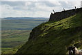
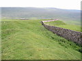
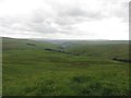
"Remains of a linear earthwork, c.2000m long, situated across a valley head guarding the access into Coverdale from Upper Wharfedale. It extends from SD 97657560 to SD 99057540 and consists mainly of an artificial ditch cut into the base of a vertical limestone scar. It is well preserved throughout. At SD 98857561 the scar terminates; but the line is strengthened and continued by a substantial artificial rampart averaging 1.8m in height. At this point gaps in both rampart and ditch suggest on original entrance. In places the rampart is abutted by small enclosures and hut circles of Iron Age type which are undoubtedly contemporary; other enclosures built into the ditch at several points, appear to be later."
Source: Pastscape.
You may be viewing yesterday's version of this page. To see the most up to date information please register for a free account.
Do not use the above information on other web sites or publications without permission of the contributor.
Nearby Images from Geograph Britain and Ireland:
©2009(licence)
©2009(licence)
©2009(licence)
©2006(licence)
©2015(licence)
The above images may not be of the site on this page, they are loaded from Geograph.
Please Submit an Image of this site or go out and take one for us!
Click here to see more info for this site
Nearby sites
Key: Red: member's photo, Blue: 3rd party photo, Yellow: other image, Green: no photo - please go there and take one, Grey: site destroyed
Download sites to:
KML (Google Earth)
GPX (GPS waypoints)
CSV (Garmin/Navman)
CSV (Excel)
To unlock full downloads you need to sign up as a Contributory Member. Otherwise downloads are limited to 50 sites.
Turn off the page maps and other distractions
Nearby sites listing. In the following links * = Image available
567m ENE 64° Little Hunters Sleets Cairn Cairn (SD98647576)
6.6km SW 227° Blue Scar (Arncliffe)* Ancient Village or Settlement (SD93237100)
7.1km SSW 204° Douky Bottom Settlement (Arncliffe) Ancient Village or Settlement (SD9520369067)
7.2km SSW 204° Dowkerbottom Cave* Cave or Rock Shelter (SD95176889)
7.3km SSW 204° Douky Bottom Ring (Arncliffe) Ancient Village or Settlement (SD9512668887)
8.1km SSW 202° Kilnsey* Stone Circle (SD951680)
8.5km SSE 158° Green Hill Pasture Stone Circle* Stone Circle (SE013676)
9.0km WNW 295° Yockenthwaite* Ring Cairn (SD8995779376)
9.2km SW 229° Dewbottoms (Arncliffe) Ancient Village or Settlement (SD912695)
9.3km S 172° Lea Green cairn Cairn (SD995663)
9.8km SSE 154° Grassington B* Stone Circle (SE025667)
9.9km SSE 154° Grassington A* Stone Circle (SE025666)
10.2km S 183° Chapel House Wood* Ancient Village or Settlement (SD9750165316)
10.2km SSW 196° Lantern Holes (Bordley)* Ancient Village or Settlement (SD95336566)
10.5km SSE 163° Yarnbury Settlement (Grassington) Ancient Village or Settlement (SE012655)
10.5km SSE 168° Grassington Settlement Ancient Village or Settlement (SE0027765259)
10.5km S 181° Brazen Gate* Round Cairn (SD9785964995)
10.6km SSE 162° Yarnbury Henge* Henge (SE0140665415)
10.7km S 170° Cove Hole* Cave or Rock Shelter (SD99896499)
10.7km SSW 196° Hammond Close Stone (Threshfield) Standing Stones (SD9516165209)
10.7km SSW 197° Druid's Altar (Yorkshire)* Stone Circle (SD94946527)
10.9km SSW 195° Hammond Close (Threshfield)* Ancient Village or Settlement (SD95386492)
11.0km S 189° Heights Cave* Cave or Rock Shelter (SD96446460)
11.2km E 97° St Chad (Middlesmoor)* Ancient Cross (SE09257414)
11.2km S 179° Little Wood* Ancient Village or Settlement (SD98266429)
View more nearby sites and additional images


 We would like to know more about this location. Please feel free to add a brief description and any relevant information in your own language.
 Wir möchten mehr über diese Stätte erfahren. Bitte zögern Sie nicht, eine kurze Beschreibung und relevante Informationen in Deutsch hinzuzufügen.
 Nous aimerions en savoir encore un peu sur les lieux. S'il vous plaît n'hesitez pas à ajouter une courte description et tous les renseignements pertinents dans votre propre langue.
 Quisieramos informarnos un poco más de las lugares. No dude en añadir una breve descripción y otros datos relevantes en su propio idioma.