

<< Text Pages >> La Roche-Bise - Standing Stone (Menhir) in France in Bretagne:Côtes-D'Armor (22)
Submitted by thecaptain on Sunday, 02 August 2009 Page Views: 2699
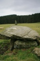
Neolithic and Bronze AgeSite Name: La Roche-BiseCountry: France
NOTE: This site is 2.809 km away from the location you searched for.
Département: Bretagne:Côtes-D'Armor (22) Type: Standing Stone (Menhir)
Nearest Town: Dinan Nearest Village: Pléslin-Trigavou
Latitude: 48.534700N Longitude: 2.0547W
Condition:
| 5 | Perfect |
| 4 | Almost Perfect |
| 3 | Reasonable but with some damage |
| 2 | Ruined but still recognisable as an ancient site |
| 1 | Pretty much destroyed, possibly visible as crop marks |
| 0 | No data. |
| -1 | Completely destroyed |
| 5 | Superb |
| 4 | Good |
| 3 | Ordinary |
| 2 | Not Good |
| 1 | Awful |
| 0 | No data. |
| 5 | Can be driven to, probably with disabled access |
| 4 | Short walk on a footpath |
| 3 | Requiring a bit more of a walk |
| 2 | A long walk |
| 1 | In the middle of nowhere, a nightmare to find |
| 0 | No data. |
| 5 | co-ordinates taken by GPS or official recorded co-ordinates |
| 4 | co-ordinates scaled from a detailed map |
| 3 | co-ordinates scaled from a bad map |
| 2 | co-ordinates of the nearest village |
| 1 | co-ordinates of the nearest town |
| 0 | no data |
Be the first person to rate this site - see the 'Contribute!' box in the right hand menu.
Internal Links:
External Links:
I have visited· I would like to visit
oldman would like to visit
You may be viewing yesterday's version of this page. To see the most up to date information please register for a free account.
Do not use the above information on other web sites or publications without permission of the contributor.
Nearby Images from Flickr

The above images may not be of the site on this page, but were taken nearby. They are loaded from Flickr so please click on them for image credits.
Click here to see more info for this site
Nearby sites
Click here to view sites on an interactive map of the areaKey: Red: member's photo, Blue: 3rd party photo, Yellow: other image, Green: no photo - please go there and take one, Grey: site destroyed
Download sites to:
KML (Google Earth)
GPX (GPS waypoints)
CSV (Garmin/Navman)
CSV (Excel)
To unlock full downloads you need to sign up as a Contributory Member. Otherwise downloads are limited to 50 sites.
Turn off the page maps and other distractions
Nearby sites listing. In the following links * = Image available
677m SSW 203° Champ des Roches* Multiple Stone Rows / Avenue
1.1km SW 232° Pierre de Minoz* Standing Stone (Menhir)
1.8km ESE 119° Beleven allée couverte* Passage Grave
5.2km SSE 149° Thiemblais menhir* Standing Stone (Menhir)
6.3km ENE 68° Gravier de Gargantua (St-Suliac) Standing Stone (Menhir)
6.8km NE 52° Saint-Suliac Abri Cave or Rock Shelter
6.8km ENE 71° Enceinte dite l'Huitière* Ancient Village or Settlement
7.0km ENE 69° Le Lit de Gargantua Burial Chamber or Dolmen
8.2km ENE 65° Dent de Gargantua* Standing Stone (Menhir)
8.5km ENE 61° La Pierre Couvretiere (St-Suliac) Burial Chamber or Dolmen
8.9km SE 132° La Ganterie* Passage Grave
9.1km NW 313° la Pierre Levée (La Mattrie)* Standing Stone (Menhir)
9.1km WNW 288° Menhir dit la Pierre du Diable (Ploubalay) Standing Stone (Menhir)
9.6km ESE 113° Allée Couverte du Bois de la Tougeais Passage Grave
9.6km ESE 113° Dolmen du Bois de la Tougeais Burial Chamber or Dolmen
9.6km ESE 113° Menhir du Bois de la Tougeais Standing Stone (Menhir)
9.6km WNW 289° Menhir de Launay* Standing Stone (Menhir)
9.8km SW 224° Temple de Mars* Ancient Temple
10.1km SW 234° Monterfil* Ancient Village or Settlement
10.2km WNW 291° Dolmen de Ville Goudier* Passage Grave
10.2km WNW 291° Trégon menhir Standing Stone (Menhir)
10.2km SW 234° Musée Archéologique de Corseul* Museum
10.2km SW 236° Coriosolis Museum* Museum
10.2km SW 236° Clos-Mulon* Ancient Village or Settlement
10.3km WNW 284° Ville-Tinguy dolmen* Burial Chamber or Dolmen
View more nearby sites and additional images


 We would like to know more about this location. Please feel free to add a brief description and any relevant information in your own language.
 Wir möchten mehr über diese Stätte erfahren. Bitte zögern Sie nicht, eine kurze Beschreibung und relevante Informationen in Deutsch hinzuzufügen.
 Nous aimerions en savoir encore un peu sur les lieux. S'il vous plaît n'hesitez pas à ajouter une courte description et tous les renseignements pertinents dans votre propre langue.
 Quisieramos informarnos un poco más de las lugares. No dude en añadir una breve descripción y otros datos relevantes en su propio idioma.