 with our Megalithic Portal iPhone app")

<< Text Pages >> Salmon Inlet - Barrow Cemetery in Canada
Submitted by bat400 on Tuesday, 25 June 2013 Page Views: 3873
Neolithic and Bronze AgeSite Name: Salmon Inlet Alternative Name: DjRw-14Country: Canada
NOTE: This site is 178.63 km away from the location you searched for.
Type: Barrow Cemetery
Nearest Town: Vancouver Nearest Village: Sechelt
Latitude: 49.630000N Longitude: 123.75W
Condition:
| 5 | Perfect |
| 4 | Almost Perfect |
| 3 | Reasonable but with some damage |
| 2 | Ruined but still recognisable as an ancient site |
| 1 | Pretty much destroyed, possibly visible as crop marks |
| 0 | No data. |
| -1 | Completely destroyed |
| 5 | Superb |
| 4 | Good |
| 3 | Ordinary |
| 2 | Not Good |
| 1 | Awful |
| 0 | No data. |
| 5 | Can be driven to, probably with disabled access |
| 4 | Short walk on a footpath |
| 3 | Requiring a bit more of a walk |
| 2 | A long walk |
| 1 | In the middle of nowhere, a nightmare to find |
| 0 | No data. |
| 5 | co-ordinates taken by GPS or official recorded co-ordinates |
| 4 | co-ordinates scaled from a detailed map |
| 3 | co-ordinates scaled from a bad map |
| 2 | co-ordinates of the nearest village |
| 1 | co-ordinates of the nearest town |
| 0 | no data |
Be the first person to rate this site - see the 'Contribute!' box in the right hand menu.
Internal Links:
External Links:
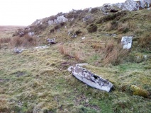
Barrow Cemetery in British Columbia.
4000 year old burial site, referred to as an ancient chieftain burial site, for the individual found in 2010, a man buried with roughly 350,000 stone handcrafted stone beads.
Excavations have been pursued through a partnership with the Sechelt Indian Band (SIB), Canadian Museum of Civilization and the University of Toronto. This a particularly important time period as it marks a change in cultural complexity and the rise of material inequality among the northwest indiginous people.
Note: The location given in general for Salmon Inlet, and does not mark the cemetery site itself.
Note: "We’ve proven ... this site is one of the most important in British Columbia — one of the most important for showing the development of chiefly status.."
You may be viewing yesterday's version of this page. To see the most up to date information please register for a free account.
Do not use the above information on other web sites or publications without permission of the contributor.
Nearby Images from Flickr

The above images may not be of the site on this page, but were taken nearby. They are loaded from Flickr so please click on them for image credits.
Click here to see more info for this site
Nearby sites
Click here to view sites on an interactive map of the areaKey: Red: member's photo, Blue: 3rd party photo, Yellow: other image, Green: no photo - please go there and take one, Grey: site destroyed
Download sites to:
KML (Google Earth)
GPX (GPS waypoints)
CSV (Garmin/Navman)
CSV (Excel)
To unlock full downloads you need to sign up as a Contributory Member. Otherwise downloads are limited to 50 sites.
Turn off the page maps and other distractions
Nearby sites listing. In the following links * = Image available
17.3km S 180° shíshálh Nation tems swiya Museum Museum
49.3km S 186° Lock Bay Site* Rock Art
53.6km SE 138° Museum of Anthropology - University of British Columbia* Museum
54.8km S 178° Degnen Bay Site* Rock Art
55.9km SE 130° Skalsh Rock* Rock Outcrop
55.9km SE 129° Coast Salish Stone Fish Weir* Stone Row / Alignment
55.9km SSW 193° Petroglyph Provincial Park (British Columbia)* Rock Art
56.7km S 184° Cedar by the Sea Petroglyphs* Rock Art
57.7km SE 129° Xwayzway Village* Ancient Village or Settlement
60.5km WNW 293° Pictographs near Powell River ferry terminal Rock Art
78.6km SE 132° Sewqueqsen Settlement at St.Mungo Cannery* Ancient Village or Settlement
78.7km SE 131° Glenrose Cannery* Ancient Village or Settlement
82.1km SE 145° Tsawwassen Long House Site* Ancient Village or Settlement
87.1km W 274° Comox Estuary* Ancient Village or Settlement
87.8km W 273° Comox Harbor Ancient Fish Trap* Ancient Mine, Quarry or other Industry
92.7km WSW 246° Sproat Lake Petroglyphs* Rock Art
96.5km SE 134° P'Quals White Rock* Natural Stone / Erratic / Other Natural Feature
120.8km ESE 116° Xaytem Ancient Native Settlement* Ancient Village or Settlement
127.7km NW 304° Ancient clam gardens on Quadra Island* Ancient Mine, Quarry or other Industry
130.2km ESE 118° Sumas Lightning Rock* Natural Stone / Erratic / Other Natural Feature
148.8km S 174° Race Rocks Ecological Reserve* Ring Cairn
154.3km SSW 205° Makah Cultural and Research Center Museum
167.9km S 173° Tse-whit-zen Barrow Cemetery
177.7km SSW 204° Ozette Ancient Village or Settlement
179.3km SSW 204° Wedding Rock* Rock Art
View more nearby sites and additional images


 We would like to know more about this location. Please feel free to add a brief description and any relevant information in your own language.
 Wir möchten mehr über diese Stätte erfahren. Bitte zögern Sie nicht, eine kurze Beschreibung und relevante Informationen in Deutsch hinzuzufügen.
 Nous aimerions en savoir encore un peu sur les lieux. S'il vous plaît n'hesitez pas à ajouter une courte description et tous les renseignements pertinents dans votre propre langue.
 Quisieramos informarnos un poco más de las lugares. No dude en añadir una breve descripción y otros datos relevantes en su propio idioma.