<< Text Pages >> Big Rock (Alberta) - Rock Art in Canada
Submitted by bat400 on Tuesday, 12 September 2017 Page Views: 6075
Rock ArtSite Name: Big Rock (Alberta) Alternative Name: Okotoks ErraticCountry: Canada Type: Rock Art
Nearest Town: Okotoks, Alberta
Latitude: 50.706000N Longitude: 114.076W
Condition:
| 5 | Perfect |
| 4 | Almost Perfect |
| 3 | Reasonable but with some damage |
| 2 | Ruined but still recognisable as an ancient site |
| 1 | Pretty much destroyed, possibly visible as crop marks |
| 0 | No data. |
| -1 | Completely destroyed |
| 5 | Superb |
| 4 | Good |
| 3 | Ordinary |
| 2 | Not Good |
| 1 | Awful |
| 0 | No data. |
| 5 | Can be driven to, probably with disabled access |
| 4 | Short walk on a footpath |
| 3 | Requiring a bit more of a walk |
| 2 | A long walk |
| 1 | In the middle of nowhere, a nightmare to find |
| 0 | No data. |
| 5 | co-ordinates taken by GPS or official recorded co-ordinates |
| 4 | co-ordinates scaled from a detailed map |
| 3 | co-ordinates scaled from a bad map |
| 2 | co-ordinates of the nearest village |
| 1 | co-ordinates of the nearest town |
| 0 | no data |
Internal Links:
External Links:

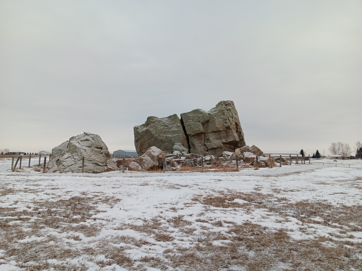
"The Big Rock" is an enormous glacial erratic – a rock transported far from its place of origin by glacial ice. This site is of great spiritual significance to the Blackfoot people, with petroglyphs having been made in the past. The name of the erratic was derived from the Blackfoot word for rock, "okatok."
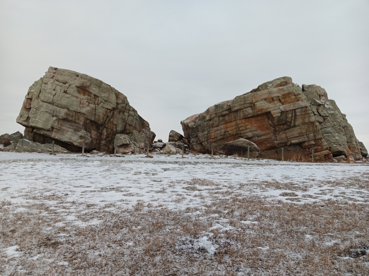
"The Okotoks Erratic is the largest known rock in the Foothills Erratics Train, a group of rocks that were carried by ice along the mountain front and let down as the glacier melted more than 10,000 years ago. The erratics lie in a narrow band extending from Jasper National Park to northern Montana. The Okotoks Erratic weighs an estimated 16,500 tonnes. It measures about 9 metres high, 41 metres long and 18 metres wide. The rock has broken into pieces, but is still a large landmark on the flat prairie."
The rock is a detached piece of the Gog Formation, made of hardened layers of sand, silt and small pebbles. Sediment was " ....deposited between 600 and 520 million years ago in a shallow sea long before the uplift of the Rocky Mountains. (The Gog Formation can be up to four kilometres thick in places.) The heat and pressure generated by the weight of the overlying sediments compacted the sand grains and cemented them into an extremely hard, durable rock called quartzite. Big Rock was originally part of a mountain in what is now Jasper National Park. During the last ice age, sometime after about 30,000 years ago, a large rockslide crashed debris onto the surface of a glacier that occupied the present day Athabasca River valley, and this debris, including Big Rock, was carried out of the mountains on the surface..." of the glacier associated with the great Laurentide ice sheet.
"One interesting feature of Big Rock is the large split down the middle. A Blackfoot story describes how this may have happened:
"One hot summer day, Napi, the supernatural trickster of the Blackfoot peoples, rested on the rock because the day was warm and he was tired. He spread his robe on the rock, telling the rock to keep the robe in return for letting Napi rest there. Suddenly, the weather changed and Napi became cold as the wind whistled and the rain fell. Napi asked the rock to return his robe, but the rock refused. Napi got mad and just took the clothing. As he strolled away, he heard a loud noise and turning, he saw the rock was rolling after him. Napi ran for his life. The deer, the bison and the pronghorn were Napi's friends, and they tried to stop the rock by running in front of it. The rock rolled over them. Napi's last chance was to call on the bats for help. Fortunately, by diving at the rock and colliding with it, one of the bats hit the rock just right and it broke into two pieces.
"Quartzite is slippery to climb and although it is hard, pieces can break off in climbers' hands. Please do not climb the rock, as tempting as it looks. Also, there are indigenous pictographs on the rock, and these could easily be damaged by climbers. Enjoy the beautiful colours, textures and feel of the rock, but stay on the ground. Please help us protect this Provincial Historical Resource for others to enjoy.
"The Okotoks Erratic is located off Highway #7, 10 kilometres southwest of Okotoks."
Source: Alberta's Provincial Historic Sites.
Note: Archeologist using 3-D imaging on Alberta's historic past. See comment.
You may be viewing yesterday's version of this page. To see the most up to date information please register for a free account.


Do not use the above information on other web sites or publications without permission of the contributor.
Click here to see more info for this site
Nearby sites
Click here to view sites on an interactive map of the areaKey: Red: member's photo, Blue: 3rd party photo, Yellow: other image, Green: no photo - please go there and take one, Grey: site destroyed
Download sites to:
KML (Google Earth)
GPX (GPS waypoints)
CSV (Garmin/Navman)
CSV (Excel)
To unlock full downloads you need to sign up as a Contributory Member. Otherwise downloads are limited to 50 sites.
Turn off the page maps and other distractions
Nearby sites listing. In the following links * = Image available
44.0km N 358° Ootssip'tomowa Look Out Hill* Hill Figure or Geoglyph
115.1km SE 125° Sundial Medicine Wheel* Ring Cairn
115.1km SSE 165° Head-Smashed-In Buffalo Jump* Ancient Mine, Quarry or other Industry
118.2km E 96° Majorville Medicine Wheel* Round Cairn
178.3km ESE 119° Fincastle Grazing Reserve Bison Kill* Ancient Mine, Quarry or other Industry
221.3km SSW 196° Crystal Lakes Golf Course Stonehenge* Modern Stone Circle etc
251.7km ESE 106° Saami Giant Teepee* Ancient Village or Settlement
251.9km NW 311° Cataract Creek Petroglyphs* Rock Art
252.2km SE 135° Writing-on-Stone Provincial Park* Rock Art
299.1km ESE 111° Stampede Site* Ancient Mine, Quarry or other Industry
311.2km SW 221° Priest Lake Pictographs Rock Art
404.0km SSE 152° First Peoples Buffalo Jump* Natural Stone / Erratic / Other Natural Feature
408.9km SW 219° Indian Painted Rocks (Spokane) Rock Art
470.6km WSW 236° Balance Rock Omak* Natural Stone / Erratic / Other Natural Feature
488.8km SSE 161° Megaliths Of Helena* Natural Stone / Erratic / Other Natural Feature
532.2km SSW 205° Red Elk Rock Shelter* Rock Art
544.7km ENE 69° Wanuskewin Heritage Park* Museum
560.6km SSW 199° Cooper's Ferry Archaeological Site* Ancient Village or Settlement
602.0km SW 228° Vantage Petroglyphs* Rock Art
608.1km WSW 256° Sumas Lightning Rock* Natural Stone / Erratic / Other Natural Feature
609.8km WSW 257° Xaytem Ancient Native Settlement* Ancient Village or Settlement
621.7km SW 226° Whale Island Petroglyphs Rock Art
623.4km SW 219° Columbia Park* Ancient Village or Settlement
626.5km SSW 199° Snake River Archaeological Site* Rock Art
652.5km WSW 257° P'Quals White Rock* Natural Stone / Erratic / Other Natural Feature
View more nearby sites and additional images


 We would like to know more about this location. Please feel free to add a brief description and any relevant information in your own language.
 Wir möchten mehr über diese Stätte erfahren. Bitte zögern Sie nicht, eine kurze Beschreibung und relevante Informationen in Deutsch hinzuzufügen.
 Nous aimerions en savoir encore un peu sur les lieux. S'il vous plaît n'hesitez pas à ajouter une courte description et tous les renseignements pertinents dans votre propre langue.
 Quisieramos informarnos un poco más de las lugares. No dude en añadir una breve descripción y otros datos relevantes en su propio idioma.