


<< Text Pages >> Navajo Nat. Mon. - Keet Seel - Ancient Village or Settlement in United States in The Southwest
Submitted by bat400 on Monday, 03 November 2008 Page Views: 5190
Multi-periodSite Name: Navajo Nat. Mon. - Keet Seel Alternative Name: Kits'iiiliCountry: United States
NOTE: This site is 14.905 km away from the location you searched for.
Region: The Southwest Type: Ancient Village or Settlement
Nearest Town: Kayenta, AZ
Latitude: 36.758800N Longitude: 110.4953W
Condition:
| 5 | Perfect |
| 4 | Almost Perfect |
| 3 | Reasonable but with some damage |
| 2 | Ruined but still recognisable as an ancient site |
| 1 | Pretty much destroyed, possibly visible as crop marks |
| 0 | No data. |
| -1 | Completely destroyed |
| 5 | Superb |
| 4 | Good |
| 3 | Ordinary |
| 2 | Not Good |
| 1 | Awful |
| 0 | No data. |
| 5 | Can be driven to, probably with disabled access |
| 4 | Short walk on a footpath |
| 3 | Requiring a bit more of a walk |
| 2 | A long walk |
| 1 | In the middle of nowhere, a nightmare to find |
| 0 | No data. |
| 5 | co-ordinates taken by GPS or official recorded co-ordinates |
| 4 | co-ordinates scaled from a detailed map |
| 3 | co-ordinates scaled from a bad map |
| 2 | co-ordinates of the nearest village |
| 1 | co-ordinates of the nearest town |
| 0 | no data |
Be the first person to rate this site - see the 'Contribute!' box in the right hand menu.
Internal Links:
External Links:
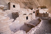
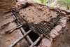
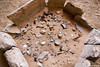
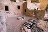
Kayenta Ancestral Puebloan Ruin in Navajo County, Arizona was built around 1250 AD but the rock shelter was first used over 300 years before that. Keet Seel is the best preserved "cliff dwelling" in Tsegi Canyon.
The ruin may only be reached by 17 mile round trip hike and a back country camping permit. A ranger on site at the ruin provides information and oversight. Guided tours on horseback may also be available, but the park visitor center should be contacted for current conditions.
Keet Seel is part of the National Park Service's Navajo National Monument and lies completely within the Navajo Reservation. The park has two small campgrounds.
You may be viewing yesterday's version of this page. To see the most up to date information please register for a free account.
Do not use the above information on other web sites or publications without permission of the contributor.
Nearby Images from Flickr

The above images may not be of the site on this page, but were taken nearby. They are loaded from Flickr so please click on them for image credits.
Click here to see more info for this site
Nearby sites
Click here to view sites on an interactive map of the areaKey: Red: member's photo, Blue: 3rd party photo, Yellow: other image, Green: no photo - please go there and take one, Grey: site destroyed
Download sites to:
KML (Google Earth)
GPX (GPS waypoints)
CSV (Garmin/Navman)
CSV (Excel)
To unlock full downloads you need to sign up as a Contributory Member. Otherwise downloads are limited to 50 sites.
Turn off the page maps and other distractions
Nearby sites listing. In the following links * = Image available
9.0km SSW 203° Navajo Nat. Mon. - Betatakin* Ancient Village or Settlement
39.6km NE 46° Monument Valley - Sun's Eye Arch Petroglyphs* Rock Art
39.6km NE 46° Monument Valley* Ancient Village or Settlement
39.6km NE 46° Monument Valley - Water Birth Cliff Petroglyphs* Rock Art
39.6km NE 46° Monument Valley - Ear of the Wind Handprint Pictographs* Rock Art
73.7km NE 51° Mexican Hat* Natural Stone / Erratic / Other Natural Feature
83.9km NE 43° Valley of the Gods* Natural Stone / Erratic / Other Natural Feature
88.4km NE 54° Comb Wash Ruins Ancient Village or Settlement
88.7km SSW 193° Taawaki Rock Art
90.3km NE 54° Kachina Petroglyph Panel Rock Art
94.7km NE 52° Wolfman Panel Petroglyphs Rock Art
95.8km NE 54° Sand Island petroglyph Panel* Rock Art
99.2km W 277° Glen Canyon - Descending Sheep Panel Petroglyph Site* Rock Art
100.4km NNE 32° Grand Gulch Primitive Area* Ancient Village or Settlement
102.0km NE 55° Bluff Great House* Ancient Village or Settlement
104.1km NNE 24° Hand Palm Paintings Rock Art
104.6km NNE 24° Natural Bridges National Monument Natural Stone / Erratic / Other Natural Feature
112.5km SW 231° Tutuveni* Rock Art
114.1km NE 41° Butler Wash* Ancient Village or Settlement
115.0km SE 127° Canyon de Chelly - White House* Ancient Village or Settlement
115.3km SE 125° Canyon de Chelly - Antelope House Ruins* Ancient Village or Settlement
117.4km ESE 120° Canyon de Chelly - Mummy Cave* Ancient Village or Settlement
118.4km SE 126° Canyon de Chelly - Sliding House* Ancient Village or Settlement
131.0km ENE 62° Hovenweep - Cajon House* Ancient Village or Settlement
131.7km NE 42° Edge of the Cedars State Park and Museum* Ancient Village or Settlement
View more nearby sites and additional images


 We would like to know more about this location. Please feel free to add a brief description and any relevant information in your own language.
 Wir möchten mehr über diese Stätte erfahren. Bitte zögern Sie nicht, eine kurze Beschreibung und relevante Informationen in Deutsch hinzuzufügen.
 Nous aimerions en savoir encore un peu sur les lieux. S'il vous plaît n'hesitez pas à ajouter une courte description et tous les renseignements pertinents dans votre propre langue.
 Quisieramos informarnos un poco más de las lugares. No dude en añadir una breve descripción y otros datos relevantes en su propio idioma.