

<< Text Pages >> Range Creek - Ancient Village or Settlement in United States in The Southwest
Submitted by bat400 on Tuesday, 28 July 2009 Page Views: 10674
Multi-periodSite Name: Range CreekCountry: United States Region: The Southwest Type: Ancient Village or Settlement
Nearest Town: Price, Utah
Latitude: 39.421000N Longitude: 110.202W
Condition:
| 5 | Perfect |
| 4 | Almost Perfect |
| 3 | Reasonable but with some damage |
| 2 | Ruined but still recognisable as an ancient site |
| 1 | Pretty much destroyed, possibly visible as crop marks |
| 0 | No data. |
| -1 | Completely destroyed |
| 5 | Superb |
| 4 | Good |
| 3 | Ordinary |
| 2 | Not Good |
| 1 | Awful |
| 0 | No data. |
| 5 | Can be driven to, probably with disabled access |
| 4 | Short walk on a footpath |
| 3 | Requiring a bit more of a walk |
| 2 | A long walk |
| 1 | In the middle of nowhere, a nightmare to find |
| 0 | No data. |
| 5 | co-ordinates taken by GPS or official recorded co-ordinates |
| 4 | co-ordinates scaled from a detailed map |
| 3 | co-ordinates scaled from a bad map |
| 2 | co-ordinates of the nearest village |
| 1 | co-ordinates of the nearest town |
| 0 | no data |
Internal Links:
External Links:
Ancient Village or Settlement in Emery County, Utah.
Rancher Waldo Wilcox realized his remote canyon home was a unique treasure, a living museum. Instead of exploiting the ancient artifacts himself, he closed off the canyon with fences at both ends and told no one about the things he had seen - for fifty years.
This amazing valley was home to people of the Freemont Culture around 600 to 1300AD. They lived in the same time frame as the Ancient Puebloans (Anasazi), but farther north in what is now known as the Great Basin in Utah.
In 2001 Wilcox approached sportsmen and legislators about opening the land in such a way that archaeologists and the public could see the sites, but like him, leave them in place. A complex usage plan was put into place as an interim step.
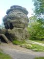
Originally the Freemont were thought to be less advanced than the Ancient Puebloans because they did not build large apartment style building complexes. However, more recent finds, including those here, show the Freemont to have a varied and complex set of technologies for making a living and detailed artistic sense. There are multiple village sites with the remains of pit houses with stone walls and timber supported roofs, storage vaults hidden in alcoves among nearly inaccessible cliffs, petrogylphs, burials, and discarded artifacts of daily life. Finds include building sites, stone tools of all types, baskets, pottery, figurines, grinding stones, leather shoes, twine, bits of cloth, and food remains. Archaeologists have GPS mapped over 300 separate sites within the 12 mile long canyon.
Called "the biggest archaeology story of 2004" when the secret public buyout leaked to the press, the story of the Range Creek finds was featured in the National Geographic Magazine August 2006 issue and a short film on the Archaeology Channel.
Currently the fences are still in place, the southern end of the area is off limits to visitors, and the Natural History Museum of Utah manages the site with a permit system allowing only 28 people per day into the area - on foot or horseback only - no camping - no camp fires. There is no visible interpretation and no guidebook. State rangers seem very happy that a sizable percentage of visitors leave disappointed because the site isn't spectacular and showy like the large building complexes of Canyon de Chelly and Mesa Verde. A few local guide services have applied for permits to take small groups into the canyon. This is probably the best method for a layman to get the most out of a visit to Range Creek.
Wilcox feared he made a wrong decision; that archaeologists will cart off the finds to museums and "hippies" will dig up the burials. Archaeologists feared that use by tourists will damage the sites and Indians promoting their religious views will cloud the meaning of the finds. Utah Indian groups were livid that they were not included in the initial planning and offended by the clinical interpretation of the Freemont culture. Hunters, fishermen, and hikers wanted to visit an area their tax money purchased and maintains.
Note: The location provided is general for the entire site, n ot for any specific feature.
[Information from David Roberts, "Guardian of a Ghost World", National Geographic Magazine, August 2006, Utah Division of Wildlife websites, and The Archaeology Channel website, among other sources.]
Note: 'Time Team America' at Range Creek. Episode aired 29 July 2009. See comment.
You may be viewing yesterday's version of this page. To see the most up to date information please register for a free account.
Do not use the above information on other web sites or publications without permission of the contributor.
Click here to see more info for this site
Nearby sites
Click here to view sites on an interactive map of the areaKey: Red: member's photo, Blue: 3rd party photo, Yellow: other image, Green: no photo - please go there and take one, Grey: site destroyed
Download sites to:
KML (Google Earth)
GPX (GPS waypoints)
CSV (Garmin/Navman)
CSV (Excel)
To unlock full downloads you need to sign up as a Contributory Member. Otherwise downloads are limited to 50 sites.
Turn off the page maps and other distractions
Nearby sites listing. In the following links * = Image available
43.7km N 354° Nine Mile Canyon* Rock Art
57.0km SSW 200° Black Dragon Canyon* Rock Art
84.9km SE 144° Dark Angel Monolith Natural Stone / Erratic / Other Natural Feature
84.9km SE 144° Dark Angel Petroglyphs B Rock Art
84.9km SE 144° Dark Angel Pictographs A Rock Art
86.9km SE 144° Landscape Arch* Natural Stone / Erratic / Other Natural Feature
90.5km E 84° Book Cliffs Rock Art
93.7km SSE 159° Bartlett Pictographs Rock Art
95.3km SSE 154° Intestine Man rock paintings Rock Art
96.2km SE 142° Wolf Ranch Petroglyphs* Rock Art
96.7km SE 141° Delicate Arch* Natural Stone / Erratic / Other Natural Feature
97.2km SE 145° Balanced Rock Arches* Natural Stone / Erratic / Other Natural Feature
99.2km SE 145° Double Arch* Natural Stone / Erratic / Other Natural Feature
100.1km SE 145° North Window Arch* Natural Stone / Erratic / Other Natural Feature
103.4km WSW 236° Rochester Rock Art Panel* Rock Art
105.2km SSE 149° Courthouse Wash Rock Art* Rock Art
106.6km S 180° Horseshoe Gallery Rock Art
106.7km S 180° High Gallery Rock Art
107.3km S 180° Alcove Gallery Rock Art
108.4km S 181° Great Gallery Horseshoe Canyon* Rock Art
110.1km SSE 151° Moonflower Petroglyphs* Rock Art
110.5km SSE 152° Potash Road petroglyphs* Rock Art
111.2km SSE 152° Poison Spider petroglyphs Rock Art
112.6km SSE 152° Birthing Rock petroglyphs* Rock Art
116.4km SSE 147° Moab Golf Course Rock Art Site Rock Art
View more nearby sites and additional images


 We would like to know more about this location. Please feel free to add a brief description and any relevant information in your own language.
 Wir möchten mehr über diese Stätte erfahren. Bitte zögern Sie nicht, eine kurze Beschreibung und relevante Informationen in Deutsch hinzuzufügen.
 Nous aimerions en savoir encore un peu sur les lieux. S'il vous plaît n'hesitez pas à ajouter une courte description et tous les renseignements pertinents dans votre propre langue.
 Quisieramos informarnos un poco más de las lugares. No dude en añadir una breve descripción y otros datos relevantes en su propio idioma.