


<< Other Photo Pages >> Lowry Pueblo - Ancient Village or Settlement in United States in The Southwest
Submitted by bat400 on Monday, 23 April 2007 Page Views: 5587
Multi-periodSite Name: Lowry PuebloCountry: United States
NOTE: This site is 20.267 km away from the location you searched for.
Region: The Southwest Type: Ancient Village or Settlement
Nearest Town: Cortez Nearest Village: Dolores
Latitude: 37.584750N Longitude: 108.92044W
Condition:
| 5 | Perfect |
| 4 | Almost Perfect |
| 3 | Reasonable but with some damage |
| 2 | Ruined but still recognisable as an ancient site |
| 1 | Pretty much destroyed, possibly visible as crop marks |
| 0 | No data. |
| -1 | Completely destroyed |
| 5 | Superb |
| 4 | Good |
| 3 | Ordinary |
| 2 | Not Good |
| 1 | Awful |
| 0 | No data. |
| 5 | Can be driven to, probably with disabled access |
| 4 | Short walk on a footpath |
| 3 | Requiring a bit more of a walk |
| 2 | A long walk |
| 1 | In the middle of nowhere, a nightmare to find |
| 0 | No data. |
| 5 | co-ordinates taken by GPS or official recorded co-ordinates |
| 4 | co-ordinates scaled from a detailed map |
| 3 | co-ordinates scaled from a bad map |
| 2 | co-ordinates of the nearest village |
| 1 | co-ordinates of the nearest town |
| 0 | no data |
Internal Links:
External Links:
")
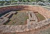
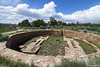
The site was built over a much earlier settlement (a grouping of pit houses.)
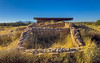
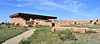
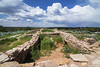
Lowry Pueblo is a National Historic Landmark and is one of only three excavated and "presented" sites within the Canyon of the Ancients Monument.
You may be viewing yesterday's version of this page. To see the most up to date information please register for a free account.
")
Do not use the above information on other web sites or publications without permission of the contributor.
Nearby Images from Flickr
The above images may not be of the site on this page, but were taken nearby. They are loaded from Flickr so please click on them for image credits.
Click here to see more info for this site
Nearby sites
Click here to view sites on an interactive map of the areaKey: Red: member's photo, Blue: 3rd party photo, Yellow: other image, Green: no photo - please go there and take one, Grey: site destroyed
Download sites to:
KML (Google Earth)
GPX (GPS waypoints)
CSV (Garmin/Navman)
CSV (Excel)
To unlock full downloads you need to sign up as a Contributory Member. Otherwise downloads are limited to 50 sites.
Turn off the page maps and other distractions
Nearby sites listing. In the following links * = Image available
75m SE 125° Lowry Pueblo - Great Kiva Ancient Temple
14.3km WSW 250° Mule Canyon* Ancient Village or Settlement
15.1km SSW 197° Hand Painted Pueblo Ancient Village or Settlement
16.7km SSW 199° Hovenweep - Cutthroat Castle* Ancient Village or Settlement
20.4km ESE 112° Yellowjacket* Ancient Village or Settlement
24.3km SSE 148° Sand Canyon Pueblo Ancient Village or Settlement
26.0km SSW 211° Hovenweep* Ancient Village or Settlement
26.3km SSW 211° Hovenweep - Stronghold House* Ancient Village or Settlement
26.3km SSW 213° Hovenweep - Square Tower* Ancient Village or Settlement
26.3km SSW 212° Hovenweep - Twin Towers* Ancient Village or Settlement
27.7km SSE 159° Saddlehorn Pueblo Ancient Village or Settlement
28.4km SSE 161° Castle Rock Pueblo Ancient Village or Settlement
29.8km SSE 157° McElmo Creek Kiva Ancient Village or Settlement
35.1km ESE 110° Escalante Pueblo* Ancient Village or Settlement
35.4km SE 137° Dillard Ancient Village or Settlement
39.4km SW 216° Hovenweep - Cajon House* Ancient Village or Settlement
42.5km SSE 151° Yucca House* Ancient Village or Settlement
48.9km NW 311° Manti-La Sal National Forest* Ancient Village or Settlement
50.4km W 276° Edge of the Cedars State Park and Museum* Ancient Village or Settlement
52.0km SE 134° Mesa Verde Ancient Village or Settlement
53.0km SE 136° Mesa Verde - Megalithic House* Ancient Village or Settlement
53.0km SE 136° Mesa Verde - Mummy Lake* Misc. Earthwork
53.2km SE 136° Mesa Verde - Far View Tower* Ancient Temple
53.3km SE 136° Mesa Verde - Coyote Village* Ancient Village or Settlement
53.3km SE 136° Mesa Verde - Far View House* Ancient Village or Settlement
View more nearby sites and additional images


 We would like to know more about this location. Please feel free to add a brief description and any relevant information in your own language.
 Wir möchten mehr über diese Stätte erfahren. Bitte zögern Sie nicht, eine kurze Beschreibung und relevante Informationen in Deutsch hinzuzufügen.
 Nous aimerions en savoir encore un peu sur les lieux. S'il vous plaît n'hesitez pas à ajouter une courte description et tous les renseignements pertinents dans votre propre langue.
 Quisieramos informarnos un poco más de las lugares. No dude en añadir una breve descripción y otros datos relevantes en su propio idioma.