


<< Our Photo Pages >> Medicine Lodge State Archeological Site - Rock Art in United States in The Northwest Mountains
Submitted by AKFisher on Friday, 25 August 2023 Page Views: 258
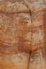
Rock ArtSite Name: Medicine Lodge State Archeological Site Alternative Name: Medicine Lodge Petroglyphs, Medicine Lodge Creek Site, 48BH499Country: United States
NOTE: This site is 45.311 km away from the location you searched for.
Region: The Northwest Mountains Type: Rock Art
Nearest Town: Hyattville, WY
Latitude: 44.298640N Longitude: 107.54155W
Condition:
| 5 | Perfect |
| 4 | Almost Perfect |
| 3 | Reasonable but with some damage |
| 2 | Ruined but still recognisable as an ancient site |
| 1 | Pretty much destroyed, possibly visible as crop marks |
| 0 | No data. |
| -1 | Completely destroyed |
| 5 | Superb |
| 4 | Good |
| 3 | Ordinary |
| 2 | Not Good |
| 1 | Awful |
| 0 | No data. |
| 5 | Can be driven to, probably with disabled access |
| 4 | Short walk on a footpath |
| 3 | Requiring a bit more of a walk |
| 2 | A long walk |
| 1 | In the middle of nowhere, a nightmare to find |
| 0 | No data. |
| 5 | co-ordinates taken by GPS or official recorded co-ordinates |
| 4 | co-ordinates scaled from a detailed map |
| 3 | co-ordinates scaled from a bad map |
| 2 | co-ordinates of the nearest village |
| 1 | co-ordinates of the nearest town |
| 0 | no data |
Internal Links:
External Links:
")
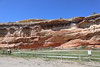
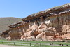
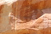
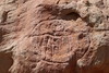
Medicine Lodge State Archeological Site is a Wyoming state park that interprets the Medicine Lodge Creek Site, a prehistoric Native American archeological site near Hyattville, Wyoming. It is administered by the Wyoming Division of State Parks and Historic Sites. The site is at the base of a steep limestone outcropping near the point where the dry and running portions of Medicine Lodge Creek join. for a protected location with ready access to water. The site includes petroglyphs and pictographs on the rock face. Excavations starting in the 1970s have found twelve levels of habitation in 10.5 feet of stratum, ranging from historic times to 8300 years before the present. The site comprises a portion of the former Wickwire Ranch, which was purchased by the state in 1972 and became to Medicine Lodge Wildlife Habitat Management Area of 12,000 acres (4,900 ha). The archeological site was designated in 1973.[2][3][4] The site is managed as a state park, with campgrounds and a visitor center. It was added to the National Register of Historic Places on July 5, 1973.[1].
Archaeological Surveys:
Largely through the efforts of Stu Conner, a long-time member of the Montana Archaeological Society and avid rock art researcher, MLC began to receive professional attention. He visited the site in 1968 to look at the rock art shortly after the corrals had been bulldozed and observed quantities of artifacts, bones, hearths, and 3 to 6 feet of cultural levels exposed by the disturbance. He photographed the petroglyphs, noting the presence of shield-bearing
warriors and animals, and contacted the Smithsonian Institution to obtain a site number—48BH499. He also contacted George Frison at the University of Wyoming, who visited the site in 1968. Frison began test excavation shortly thereafter which started a massive, long-term research project at MLC and other nearby sites in the mid-1970s funded by the National Science Foundation. This project revealed nearly 10,000 years of human occupation of MLC and reconstructed changing environmental conditions. It also documented key differences beginning in late Paleoindian times between foothills, mountain and Plains cultural groups by demonstrating the importance of smaller game and gathering of plants, as compared to big-game hunting.[5] Source: Wikipedia (see link below)
References:
1. National Register Information System. National Register of Historic Places. National Park Service. July 9, 2010.
2. Medicine Lodge Archaeological Site. Wyoming State Historical Society. November 8, 2014. Retrieved February 21, 2018.
3. About - Medicine Lodge. Retrieved February 21, 2018.
4. Medicine Lodge Creek Site. Wyoming State Historic Preservation Office.
5. Loendorf and Francis, Wyoming State Parks brochure, "Rock Art at Medicine Lodge State Archaeological Site," edition 2021.
Further reading and information:
Wikipedia
en.wikipedia.org/wiki/Medicine_Lodge_State_Archeological_Site<2>
Wyoming Historical Society
http://www.wyohistory.org/encyclopedia/medicine-lodge<4>
Directions:
From Hyattville, WY via Cold Springs Rd. and Co. Rd. 52, 6.4 mi.
You may be viewing yesterday's version of this page. To see the most up to date information please register for a free account.
")
")
")
")
Do not use the above information on other web sites or publications without permission of the contributor.
Nearby Images from Flickr

The above images may not be of the site on this page, but were taken nearby. They are loaded from Flickr so please click on them for image credits.
Click here to see more info for this site
Nearby sites
Click here to view sites on an interactive map of the areaKey: Red: member's photo, Blue: 3rd party photo, Yellow: other image, Green: no photo - please go there and take one, Grey: site destroyed
Download sites to:
KML (Google Earth)
GPX (GPS waypoints)
CSV (Garmin/Navman)
CSV (Excel)
To unlock full downloads you need to sign up as a Contributory Member. Otherwise downloads are limited to 50 sites.
Turn off the page maps and other distractions
Nearby sites listing. In the following links * = Image available
65.9km NNW 333° Bighorn Medicine Wheel* Stone Circle
101.2km WSW 237° Legend Rock* Rock Art
109.5km NW 316° Petroglyph Canyon (Cowley)* Rock Art
152.4km S 182° Castle Gardens* Rock Art
158.9km NW 317° Valley of the Shields* Rock Art
174.6km NNW 337° Pictograph Caves* Rock Art
175.3km W 277° Mummy Cave* Cave or Rock Shelter
193.5km WSW 241° High Rise Village Ancient Village or Settlement
207.2km SE 141° Glenrock Buffalo Jump* Natural Stone / Erratic / Other Natural Feature
225.1km W 275° Yellowstone Lake* Ancient Village or Settlement
227.0km E 88° Arch Creek Petroglyphs* Rock Art
227.9km E 81° Devil's Tower National Monument* Natural Stone / Erratic / Other Natural Feature
259.1km WNW 284° Obsidian Cliff* Ancient Mine, Quarry or other Industry
270.1km E 83° Vore Buffalo Jump* Natural Stone / Erratic / Other Natural Feature
302.0km SSW 208° White Mountain Wyoming* Rock Art
315.7km SE 131° Hell Gap* Ancient Village or Settlement
357.1km ESE 116° Hudson-Meng Bison Kill* Ancient Mine, Quarry or other Industry
421.0km SSE 150° Lindenmeier Site* Ancient Mine, Quarry or other Industry
424.7km NW 307° Megaliths Of Helena* Natural Stone / Erratic / Other Natural Feature
433.9km SSW 196° Dinosaur National Monument* Rock Art
448.8km ESE 121° Carhenge, Nebraska* Modern Stone Circle etc
469.0km NW 320° First Peoples Buffalo Jump* Natural Stone / Erratic / Other Natural Feature
521.7km SW 233° Great Salt Lake Cave* Cave or Rock Shelter
546.7km SSW 205° Nine Mile Canyon* Rock Art
549.1km SSW 195° Book Cliffs Rock Art
View more nearby sites and additional images


 We would like to know more about this location. Please feel free to add a brief description and any relevant information in your own language.
 Wir möchten mehr über diese Stätte erfahren. Bitte zögern Sie nicht, eine kurze Beschreibung und relevante Informationen in Deutsch hinzuzufügen.
 Nous aimerions en savoir encore un peu sur les lieux. S'il vous plaît n'hesitez pas à ajouter une courte description et tous les renseignements pertinents dans votre propre langue.
 Quisieramos informarnos un poco más de las lugares. No dude en añadir una breve descripción y otros datos relevantes en su propio idioma.