


<< Our Photo Pages >> La Quemada - Ancient Village or Settlement in Mexico in Zacatecas
Submitted by SolarMegalith on Thursday, 07 May 2015 Page Views: 7745
Multi-periodSite Name: La QuemadaCountry: Mexico
NOTE: This site is 29.974 km away from the location you searched for.
Region: Zacatecas Type: Ancient Village or Settlement
Nearest Town: Villanueva
Latitude: 22.456838N Longitude: 102.821422W
Condition:
| 5 | Perfect |
| 4 | Almost Perfect |
| 3 | Reasonable but with some damage |
| 2 | Ruined but still recognisable as an ancient site |
| 1 | Pretty much destroyed, possibly visible as crop marks |
| 0 | No data. |
| -1 | Completely destroyed |
| 5 | Superb |
| 4 | Good |
| 3 | Ordinary |
| 2 | Not Good |
| 1 | Awful |
| 0 | No data. |
| 5 | Can be driven to, probably with disabled access |
| 4 | Short walk on a footpath |
| 3 | Requiring a bit more of a walk |
| 2 | A long walk |
| 1 | In the middle of nowhere, a nightmare to find |
| 0 | No data. |
| 5 | co-ordinates taken by GPS or official recorded co-ordinates |
| 4 | co-ordinates scaled from a detailed map |
| 3 | co-ordinates scaled from a bad map |
| 2 | co-ordinates of the nearest village |
| 1 | co-ordinates of the nearest town |
| 0 | no data |
Internal Links:
External Links:
")
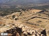
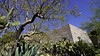
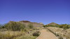
Las Quemada was one of the largest Pre-Colombian cities in area of current Zacatecas. It was occupied since 200 AD to 1000 AD, with heyday around 500 AD. Among the main buildings there is over 10 m high Piramide Votiva (Votive Pyramid), Palacio de las Columnas (Palace of the Columns) and Ciudadela (Citadel).
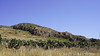
The ruins are located around top of a hill with Citadel on its top.
Note: Bone analysis reveals violent history of pre-Hispanic Mesoamerica. See comment.
You may be viewing yesterday's version of this page. To see the most up to date information please register for a free account.
")
Do not use the above information on other web sites or publications without permission of the contributor.
Nearby Images from Flickr

The above images may not be of the site on this page, but were taken nearby. They are loaded from Flickr so please click on them for image credits.
Click here to see more info for this site
Nearby sites
Click here to view sites on an interactive map of the areaKey: Red: member's photo, Blue: 3rd party photo, Yellow: other image, Green: no photo - please go there and take one, Grey: site destroyed
Download sites to:
KML (Google Earth)
GPX (GPS waypoints)
CSV (Garmin/Navman)
CSV (Excel)
To unlock full downloads you need to sign up as a Contributory Member. Otherwise downloads are limited to 50 sites.
Turn off the page maps and other distractions
Nearby sites listing. In the following links * = Image available
103.3km NNE 25° La Florida (Zacatecas) Shaft Tomb* Chambered Tomb
130.3km SSW 211° El Teul Archaeological Zone Ancient Village or Settlement
222.1km SSW 208° Los Guachimontones* Ancient Temple
227.1km WSW 249° Cantil de las animas Rock Art
264.3km SE 132° Cañada de la Virgen Ancient Village or Settlement
299.7km WNW 300° Cueva del Maguey Ancient Village or Settlement
316.5km SSE 150° Huandacareo Ancient Village or Settlement
324.6km SE 130° El Cerrito Pyramid / Mastaba
335.5km WSW 237° Careyeros Hill Ancient Village or Settlement
337.8km S 170° Purepecha Digs Ancient Village or Settlement
338.5km SSE 156° Purépecha Proto Urban Site Ancient Village or Settlement
340.6km SSE 157° Tzintzuntzan* Ancient Village or Settlement
343.5km SSE 159° Ihuatzio* Ancient Village or Settlement
344.3km SSE 163° Tingambato* Ancient Village or Settlement
348.1km SSE 157° Sacapu Angamuco Ancient Village or Settlement
366.4km SSE 163° Tipitarillo Yacata Pyramid / Mastaba
369.8km SSW 195° Colima - Eastern Shaft Tomb* Barrow Cemetery
393.7km ENE 71° Balcon de Montezuma Ancient Village or Settlement
412.0km SE 131° Huamango Ancient Village or Settlement
417.0km E 97° Tamtoc Ancient Village or Settlement
424.0km WNW 289° Las Labradas* Rock Art
448.3km SE 126° Tula.* Ancient Village or Settlement
456.0km NNE 29° Boca de Potrerillos Rock Art
490.1km SE 139° Nevado de Toluca Natural Stone / Erratic / Other Natural Feature
497.7km SE 130° Acatitlan* Ancient Temple
View more nearby sites and additional images


 We would like to know more about this location. Please feel free to add a brief description and any relevant information in your own language.
 Wir möchten mehr über diese Stätte erfahren. Bitte zögern Sie nicht, eine kurze Beschreibung und relevante Informationen in Deutsch hinzuzufügen.
 Nous aimerions en savoir encore un peu sur les lieux. S'il vous plaît n'hesitez pas à ajouter une courte description et tous les renseignements pertinents dans votre propre langue.
 Quisieramos informarnos un poco más de las lugares. No dude en añadir una breve descripción y otros datos relevantes en su propio idioma.