 with our Megalithic Portal iPhone app")


<< Other Photo Pages >> Picture Canyon - Rock Art in United States in The Plains
Submitted by AKFisher on Saturday, 12 August 2023 Page Views: 272
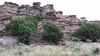
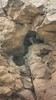
Rock ArtSite Name: Picture Canyon Alternative Name: Picture Canyon Colorado, Picture Canyon Comanche National GrasslandCountry: United States
NOTE: This site is 17.966 km away from the location you searched for.
Region: The Plains Type: Rock Art
Nearest Town: Springfield, CO
Latitude: 37.012560N Longitude: 102.74467W
Condition:
| 5 | Perfect |
| 4 | Almost Perfect |
| 3 | Reasonable but with some damage |
| 2 | Ruined but still recognisable as an ancient site |
| 1 | Pretty much destroyed, possibly visible as crop marks |
| 0 | No data. |
| -1 | Completely destroyed |
| 5 | Superb |
| 4 | Good |
| 3 | Ordinary |
| 2 | Not Good |
| 1 | Awful |
| 0 | No data. |
| 5 | Can be driven to, probably with disabled access |
| 4 | Short walk on a footpath |
| 3 | Requiring a bit more of a walk |
| 2 | A long walk |
| 1 | In the middle of nowhere, a nightmare to find |
| 0 | No data. |
| 5 | co-ordinates taken by GPS or official recorded co-ordinates |
| 4 | co-ordinates scaled from a detailed map |
| 3 | co-ordinates scaled from a bad map |
| 2 | co-ordinates of the nearest village |
| 1 | co-ordinates of the nearest town |
| 0 | no data |
Internal Links:
External Links:
")
Picture Canyon, located in the Comanche National Grassland in southeastern Colorado, was named for its prehistoric rock art. There is evidence of prehistoric inhabitation of sites in Picture Canyon by Paleo-Indian, Archaic and Post-Archaic cultures, from about 12,000 years ago to 400 years ago. In addition to rock art, there are also carvings in walls that are used to identify the entry into fall and spring equinoxes.
Recreation area:
It is a small canyon with easy slopes, springs, picnic tables, and a loop hiking trail 4 miles (6.4 km) long.[1] Natural attractions include rock formations, such as Balanced Rock, and Crack Cave.[1]
Archaeological site:
Paleo-Indian
Projectile points found in the Comanche National Grasslands are estimated to be 12,000 years old, evidence of Paleo-Indian hunters.[1]
Plains Archaic Period:
Rock shelters have been found in Picture Canyon and other nearby locations by hunter-gatherers from the Plains Archaic Period, from 250 B.C. to A.D. 500. Most of the shelters were near sources of water and faced south, which would have been warmed by the sun in the winter. Material goods found in the shelters include metates and manos, stitching awls, abraders, hammerstones, knives, and scrapers. Some of the rock shelters contained rock art.[1]
Plains Woodland Period:
While there is some evidence of rock shelter inhabitation by the Plains Woodland culture, the primary evidence is found in open-air sites. The dwellings were simple structures made of stone slaps or brush. Some sites show evidence of farming. Material goods found include corner-notched projectile points used for bow and arrow hunting and cord-marked Woodland grit-tempered pottery.[1]
Apishapa culture:
The Apishapa lived on the canyon rim and farmed on the canyon floor.[2] Their homes, built on the lowest portion of a mesa or above the creek flood plains, provided great visibility in three directions and easy access to the farmland. The dwellings were round or oval structures, 15 to 21 feet (4.6 to 6.4 m) in diameter, were built in groupings of 3 to 4 buildings. They were covered by wooden poles, brush and possibly animal hides and contained hearths up to 19 feet (5.8 m) wide for cooking and warmth. Material goods included metates and manos for processing acorn and maize, and tools made of imported chert, obsidian and petrified wood. The Apishapa lived in the dwellings during spring planting and fall harvesting.[1]
Tipi ring period:
The possible ancestors of the Apache built tipis in the area about A.D. 1350, during what is called the "Tipi ring period" with sites of up to 44 tipi rings and circular arrangement of stones. The sites were located along canyon rims and at canyon heads for short periods of time, likely only for several days to several weeks. The limited material goods found include beads made of imported turquoise, cord-marked pottery, imported San Lazaro Glaze Polychrome pottery made during the Ancient Pueblo People Pueblo IV Era and, in one site, Taos Pueblo or Picuris Pueblo mica tempered pottery made after A.D. 1500.[1]
Rock art and solar markings:
The south canyon walls of Picture Canyon contain rock art, red and black pictographs and human and animal petroglyphs, that were likely made by Plains Indians in the 17th and early 18th centuries.[1] Horizontal lines of writing were found there, similar to 50 sites in Oklahoma and southeastern Colorado, which have been translated to include solar, planting and travel related information.[2]
Markings in the walls of Crack Cave were made more than 1,000 years ago which are illuminated by rays of the sun during the spring and autumn equinox. Free tours are conducted by the National Forest Service on equinox dates in March and September.[1]
References:
1. Picture Canyon. Santa Fe Trails Scenic and Historic Byway. Retrieved November 28, 2011.
2. Green, Stewart M. (2008) [1994]. Scenic Driving Colorado. Morris Book Publishing. p. 28. ISSN 1544-8355.
Further reading and information:
Wikipedia: en.wikipedia.org/wiki/Picture_Canyon_(Colorado)
USDA / Forest Service: www.fs.usda.gov/recarea/psicc/recreation/recarea/?recid=12436
Directions:
From Springfield, Colorado drive south on Highway 287 for 17 miles; turn right (west) on County Road M for 8 miles; turn left (south) on County Road 18 for 8 miles; turn right (south) at the Picture Canyon road sign (Forest Service Road 2361) and continue on into the recreation area.
You may be viewing yesterday's version of this page. To see the most up to date information please register for a free account.
")
Do not use the above information on other web sites or publications without permission of the contributor.
Nearby Images from Flickr


The above images may not be of the site on this page, but were taken nearby. They are loaded from Flickr so please click on them for image credits.
Click here to see more info for this site
Nearby sites
Click here to view sites on an interactive map of the areaKey: Red: member's photo, Blue: 3rd party photo, Yellow: other image, Green: no photo - please go there and take one, Grey: site destroyed
Download sites to:
KML (Google Earth)
GPX (GPS waypoints)
CSV (Garmin/Navman)
CSV (Excel)
To unlock full downloads you need to sign up as a Contributory Member. Otherwise downloads are limited to 50 sites.
Turn off the page maps and other distractions
Nearby sites listing. In the following links * = Image available
8.3km S 172° Crack Cave Rock Art
85.7km NW 315° Pinon Canyon Rock Art
257.6km WSW 257° Taos Pueblo* Ancient Village or Settlement
286.9km E 99° Badger Hole (Oklahoma)* Ancient Mine, Quarry or other Industry
291.0km NW 320° U.S. Air Force Academy Modern Stone Circle Modern Stone Circle etc
308.6km S 190° Blackwater Draw* Museum
332.0km WSW 251° Puye Cliff Dwellings* Cave or Rock Shelter
344.0km WSW 248° Bandelier National Monument* Ancient Village or Settlement
344.2km WSW 248° Bandelier National Mounument - Tyuonyi* Ancient Village or Settlement
344.3km WSW 248° Bandelier National Monument - Long House* Ancient Village or Settlement
344.8km WSW 248° Bandelier National Monument - Alcove House* Ancient Village or Settlement
381.1km WSW 250° Jemez Gallina Culture* Ancient Village or Settlement
405.0km W 274° Chimney Rock - Great House* Ancient Village or Settlement
409.4km WSW 240° Maxwell Museum of Anthropology* Museum
412.3km WSW 241° Boca Negra Canyon* Rock Art
417.0km WSW 241° Petroglyph Nat. Mon.* Rock Art
417.0km WSW 241° Petroglyph National Monument Rock Art
437.4km W 269° Simon Canyon Ruins* Ancient Village or Settlement
455.4km WSW 257° Pueblo Pintado* Ancient Village or Settlement
456.0km WSW 238° Los Lunas Decalogue Stone* Marker Stone
461.3km W 274° Sacred Ridge Ancient Village or Settlement
467.6km W 269° Aztec Ruins National Monument* Ancient Village or Settlement
470.5km WSW 258° Chaco Culture NHP* Ancient Village or Settlement
470.9km WSW 258° Chaco Culture NHP - Wijiji Ancient Village or Settlement
471.2km W 267° Salmon Ruins* Ancient Village or Settlement
View more nearby sites and additional images


 We would like to know more about this location. Please feel free to add a brief description and any relevant information in your own language.
 Wir möchten mehr über diese Stätte erfahren. Bitte zögern Sie nicht, eine kurze Beschreibung und relevante Informationen in Deutsch hinzuzufügen.
 Nous aimerions en savoir encore un peu sur les lieux. S'il vous plaît n'hesitez pas à ajouter une courte description et tous les renseignements pertinents dans votre propre langue.
 Quisieramos informarnos un poco más de las lugares. No dude en añadir una breve descripción y otros datos relevantes en su propio idioma.