


<< Other Photo Pages >> Tingambato - Ancient Village or Settlement in Mexico in Mexico Other
Submitted by davidmorgan on Tuesday, 05 February 2019 Page Views: 917
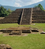
Multi-periodSite Name: TingambatoCountry: Mexico
NOTE: This site is 20.945 km away from the location you searched for.
Region: Mexico Other Type: Ancient Village or Settlement
Nearest Town: Tingambato
Latitude: 19.494200N Longitude: 101.8587W
Condition:
| 5 | Perfect |
| 4 | Almost Perfect |
| 3 | Reasonable but with some damage |
| 2 | Ruined but still recognisable as an ancient site |
| 1 | Pretty much destroyed, possibly visible as crop marks |
| 0 | No data. |
| -1 | Completely destroyed |
| 5 | Superb |
| 4 | Good |
| 3 | Ordinary |
| 2 | Not Good |
| 1 | Awful |
| 0 | No data. |
| 5 | Can be driven to, probably with disabled access |
| 4 | Short walk on a footpath |
| 3 | Requiring a bit more of a walk |
| 2 | A long walk |
| 1 | In the middle of nowhere, a nightmare to find |
| 0 | No data. |
| 5 | co-ordinates taken by GPS or official recorded co-ordinates |
| 4 | co-ordinates scaled from a detailed map |
| 3 | co-ordinates scaled from a bad map |
| 2 | co-ordinates of the nearest village |
| 1 | co-ordinates of the nearest town |
| 0 | no data |
Internal Links:
External Links:
")
A Teotihuacan style settlement dating from 450 - 950 CE.
You may be viewing yesterday's version of this page. To see the most up to date information please register for a free account.
")
")
")
")
Do not use the above information on other web sites or publications without permission of the contributor.
Nearby Images from Flickr


The above images may not be of the site on this page, but were taken nearby. They are loaded from Flickr so please click on them for image credits.
Click here to see more info for this site
Nearby sites
Click here to view sites on an interactive map of the areaKey: Red: member's photo, Blue: 3rd party photo, Yellow: other image, Green: no photo - please go there and take one, Grey: site destroyed
Download sites to:
KML (Google Earth)
GPX (GPS waypoints)
CSV (Garmin/Navman)
CSV (Excel)
To unlock full downloads you need to sign up as a Contributory Member. Otherwise downloads are limited to 50 sites.
Turn off the page maps and other distractions
Nearby sites listing. In the following links * = Image available
22.2km SSE 168° Tipitarillo Yacata Pyramid / Mastaba
26.5km ENE 69° Ihuatzio* Ancient Village or Settlement
33.2km ENE 64° Tzintzuntzan* Ancient Village or Settlement
38.5km ENE 76° Sacapu Angamuco Ancient Village or Settlement
39.9km ENE 62° Purépecha Proto Urban Site Ancient Village or Settlement
41.1km W 266° Purepecha Digs Ancient Village or Settlement
81.5km NE 47° Huandacareo Ancient Village or Settlement
180.1km NNE 32° Cañada de la Virgen Ancient Village or Settlement
188.9km NE 51° El Cerrito Pyramid / Mastaba
197.7km W 262° Colima - Eastern Shaft Tomb* Barrow Cemetery
215.4km ENE 75° Huamango Ancient Village or Settlement
224.6km E 101° Nevado de Toluca Natural Stone / Erratic / Other Natural Feature
225.7km SSE 166° Xihuacan Pyramid / Mastaba
241.3km E 100° Teotenango* Ancient Temple
246.0km WNW 303° Los Guachimontones* Ancient Temple
271.4km ENE 76° Tula.* Ancient Village or Settlement
274.5km NW 323° El Teul Archaeological Zone Ancient Village or Settlement
279.9km ESE 106° Xochicalco* Ancient Village or Settlement
280.3km E 91° Museo Nacional de Antropología* Museum
281.5km E 88° Acatitlan* Ancient Temple
281.6km E 94° Cuicuilco* Pyramid / Mastaba
282.0km E 89° Tenayuca* Pyramid / Mastaba
283.3km E 94° Tlalpan Ancient Village or Settlement
283.9km ESE 102° Cuernavaca - Piramide de Teopanzolco* Pyramid / Mastaba
285.3km E 91° Tlatelolco* Ancient Village or Settlement
View more nearby sites and additional images


 We would like to know more about this location. Please feel free to add a brief description and any relevant information in your own language.
 Wir möchten mehr über diese Stätte erfahren. Bitte zögern Sie nicht, eine kurze Beschreibung und relevante Informationen in Deutsch hinzuzufügen.
 Nous aimerions en savoir encore un peu sur les lieux. S'il vous plaît n'hesitez pas à ajouter une courte description et tous les renseignements pertinents dans votre propre langue.
 Quisieramos informarnos un poco más de las lugares. No dude en añadir una breve descripción y otros datos relevantes en su propio idioma.