


<< Text Pages >> Nevado de Toluca - Natural Stone / Erratic / Other Natural Feature in Mexico in Mexico Other
Submitted by bat400 on Tuesday, 28 December 2010 Page Views: 8859
Natural PlacesSite Name: Nevado de Toluca Alternative Name: XinantécatlCountry: Mexico
NOTE: This site is 82.921 km away from the location you searched for.
Region: Mexico Other Type: Natural Stone / Erratic / Other Natural Feature
Nearest Town: Toluca
Latitude: 19.106430N Longitude: 99.758105W
Condition:
| 5 | Perfect |
| 4 | Almost Perfect |
| 3 | Reasonable but with some damage |
| 2 | Ruined but still recognisable as an ancient site |
| 1 | Pretty much destroyed, possibly visible as crop marks |
| 0 | No data. |
| -1 | Completely destroyed |
| 5 | Superb |
| 4 | Good |
| 3 | Ordinary |
| 2 | Not Good |
| 1 | Awful |
| 0 | No data. |
| 5 | Can be driven to, probably with disabled access |
| 4 | Short walk on a footpath |
| 3 | Requiring a bit more of a walk |
| 2 | A long walk |
| 1 | In the middle of nowhere, a nightmare to find |
| 0 | No data. |
| 5 | co-ordinates taken by GPS or official recorded co-ordinates |
| 4 | co-ordinates scaled from a detailed map |
| 3 | co-ordinates scaled from a bad map |
| 2 | co-ordinates of the nearest village |
| 1 | co-ordinates of the nearest town |
| 0 | no data |
Internal Links:
External Links:
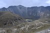
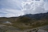
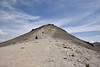
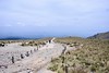
Volcano in Mexico State, Mexico. 1,300 year-old ceramic fragments and greenstone beads were found in the crater of this volcano, representing the earliest ritual objects found so far at the high mountain ceremonial space.
The Lake of the Moon and the Lake of the Sun are two lakes formed in the crater of the extinct Nevado de Toluca Volcano. Offering artefacts indicate that people used the volcano and the lakes as sacred sites from as early as 100BC and into the era of the Spanish Conquest.
It is the 4th highest peak in Mexico. Archaeologists have been diving in the Sun and Moon lagoons in the crater at 4,300 metres altitude.
Note: Mexican Archaeologists Report Finding Prehispanic Objects at Nevado de Toluca
You may be viewing yesterday's version of this page. To see the most up to date information please register for a free account.
Do not use the above information on other web sites or publications without permission of the contributor.
Nearby Images from Flickr


The above images may not be of the site on this page, but were taken nearby. They are loaded from Flickr so please click on them for image credits.
Click here to see more info for this site
Nearby sites
Click here to view sites on an interactive map of the areaKey: Red: member's photo, Blue: 3rd party photo, Yellow: other image, Green: no photo - please go there and take one, Grey: site destroyed
Download sites to:
KML (Google Earth)
GPX (GPS waypoints)
CSV (Garmin/Navman)
CSV (Excel)
To unlock full downloads you need to sign up as a Contributory Member. Otherwise downloads are limited to 50 sites.
Turn off the page maps and other distractions
Nearby sites listing. In the following links * = Image available
17.0km E 89° Teotenango* Ancient Temple
59.1km SE 125° Xochicalco* Ancient Village or Settlement
59.7km ESE 109° Cuernavaca - Piramide de Teopanzolco* Pyramid / Mastaba
64.3km ENE 70° Cuicuilco* Pyramid / Mastaba
65.3km ENE 72° Tlalpan Ancient Village or Settlement
69.7km ENE 59° Museo Nacional de Antropología* Museum
70.0km E 100° Tepoztlan* Ancient Village or Settlement
75.2km ENE 61° Tenochtitlan - Templo Mayor* Ancient Temple
75.6km ENE 59° Tlatelolco* Ancient Village or Settlement
77.9km NE 52° Tenayuca* Pyramid / Mastaba
78.9km NE 51° Acatitlan* Ancient Temple
90.2km SSE 155° Xihuatoxtla Cave or Rock Shelter
97.7km N 353° Huamango Ancient Village or Settlement
107.8km ENE 66° Texcotzingo* Ancient Palace
114.3km ESE 115° Chalcatzingo* Rock Art
114.8km NE 56° Teotihuacan - Tetitla Ancient Village or Settlement
115.0km NE 56° Teotihuacan - Temple of Quetzalcoatl* Pyramid / Mastaba
115.1km NE 55° Teotihuacan - Atelelco* Ancient Palace
115.6km NNE 22° Tula.* Ancient Village or Settlement
115.7km NE 56° Teotihuacan* Ancient Village or Settlement
115.9km NE 56° Teotihuacan - Pyramid of the Sun* Pyramid / Mastaba
116.4km NE 55° Teotihuacan - Pyramid of the Moon* Pyramid / Mastaba
148.5km ENE 58° Tepeapulco Pyramid* Pyramid / Mastaba
148.7km E 84° Xochitecatl* Pyramid / Mastaba
149.3km E 84° Cacaxtla* Ancient Village or Settlement
View more nearby sites and additional images


 We would like to know more about this location. Please feel free to add a brief description and any relevant information in your own language.
 Wir möchten mehr über diese Stätte erfahren. Bitte zögern Sie nicht, eine kurze Beschreibung und relevante Informationen in Deutsch hinzuzufügen.
 Nous aimerions en savoir encore un peu sur les lieux. S'il vous plaît n'hesitez pas à ajouter une courte description et tous les renseignements pertinents dans votre propre langue.
 Quisieramos informarnos un poco más de las lugares. No dude en añadir una breve descripción y otros datos relevantes en su propio idioma.