


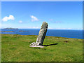
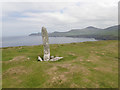
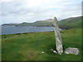
<< Our Photo Pages >> An Dún Mór Ogham stone - Early Christian Sculptured Stone in Ireland (Republic of) in Co. Kerry
Submitted by GaelicLaird on Sunday, 14 August 2022 Page Views: 1259
Early Medieval (Dark Age)Site Name: An Dún Mór Ogham stone Alternative Name: Dunmore ogham stoneCountry: Ireland (Republic of)
NOTE: This site is 2.424 km away from the location you searched for.
County: Co. Kerry Type: Early Christian Sculptured Stone
Nearest Village: Dunquin
Latitude: 52.110286N Longitude: 10.473174W
Condition:
| 5 | Perfect |
| 4 | Almost Perfect |
| 3 | Reasonable but with some damage |
| 2 | Ruined but still recognisable as an ancient site |
| 1 | Pretty much destroyed, possibly visible as crop marks |
| 0 | No data. |
| -1 | Completely destroyed |
| 5 | Superb |
| 4 | Good |
| 3 | Ordinary |
| 2 | Not Good |
| 1 | Awful |
| 0 | No data. |
| 5 | Can be driven to, probably with disabled access |
| 4 | Short walk on a footpath |
| 3 | Requiring a bit more of a walk |
| 2 | A long walk |
| 1 | In the middle of nowhere, a nightmare to find |
| 0 | No data. |
| 5 | co-ordinates taken by GPS or official recorded co-ordinates |
| 4 | co-ordinates scaled from a detailed map |
| 3 | co-ordinates scaled from a bad map |
| 2 | co-ordinates of the nearest village |
| 1 | co-ordinates of the nearest town |
| 0 | no data |
Internal Links:
External Links:
")
The ogham stone is officially recorded as monument number KE052-059002-
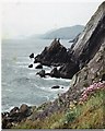
An Dún Mór (Dunmore) is a large headland, rising 328 feet/100m OD, and projects W into the Blasket Sound at the extreme W tip of the Dingle Peninsula.
The final A is not visible either, but is included in most earlier accounts. Westropp (1910, 291) suggests that Dunmore may have been a place of ritual, a sanctuary of the goddess Duibhne.
The above description is derived from J. Cuppage, ‘Corca Dhuibhne. Dingle Peninsula archaeological survey. Ballyferriter. Oidhreacht Chorca Dhuibhne’ (1986), no. 268.
This stone has been studied as part of the ‘Ogham in 3D’ project undertaken by the School of Celtic Studies, Dublin Institute for Advanced Studies. To access details go to the following website: http://ogham.celt.dias.ie/search.php?ciic=178
This monument is subject to a preservation order made under the National Monuments Acts 1930 to 2014 (PO no. 1/2004).
I may be wrong here but I'm going to suggest that this is the most westerly ogham stone still standing in Europe. Records show there was an ogham stone on nearby Innishvickillane island a few kms to the south west of this site however that stone has been moved and is now sited on display at Trinity College, Dublin as part of The Book of Kells Exhibition. As far as I can ascertain there is currently no ogham further west than the An Dún Mór stone, although if a reader knows of one I'll happily be corrected on this.
You may be viewing yesterday's version of this page. To see the most up to date information please register for a free account.
")
")
")
Do not use the above information on other web sites or publications without permission of the contributor.
Nearby Images from Geograph Britain and Ireland:
©2005(licence)
©2018(licence)
©2018(licence)
©2010(licence)
©2009(licence)
The above images may not be of the site on this page, they are loaded from Geograph.
Please Submit an Image of this site or go out and take one for us!
Click here to see more info for this site
Nearby sites
Click here to view sites on an interactive map of the areaKey: Red: member's photo, Blue: 3rd party photo, Yellow: other image, Green: no photo - please go there and take one, Grey: site destroyed
Download sites to:
KML (Google Earth)
GPX (GPS waypoints)
CSV (Garmin/Navman)
CSV (Excel)
To unlock full downloads you need to sign up as a Contributory Member. Otherwise downloads are limited to 50 sites.
Turn off the page maps and other distractions
Nearby sites listing. In the following links * = Image available
2.3km ESE 104° Caher Conor* Stone Fort or Dun (V328976)
4.5km E 100° Dunbeg* Stone Fort or Dun (V3502297293)
4.5km E 97° Fahan Standing Stones (V351975)
5.1km N 7° Clogher Stone Row / Alignment (Q314033)
6.4km NNE 30° Teeravane Stone Circle (Q340037)
7.2km NE 38° Altóir na Gréine* Wedge Tomb
7.9km ENE 67° Giant's Table* Wedge Tomb (Q3801)
8.0km NE 39° Ballineanig-Castlequarter Standing Stones (Q359043)
8.7km ENE 64° Kilcolman Cross-Inscribed Ogham Stone* Early Christian Sculptured Stone (Q386017)
8.8km NE 42° Reask* Early Christian Sculptured Stone (Q367046)
9.6km NE 37° Baile an Reannaigh ogham stone* Ancient Village or Settlement
9.7km NE 55° Leataoibh Meánach standing stone* Standing Stone (Menhir)
10.9km NE 50° Gallarus Oratory* Ancient Temple (Q392049)
11.5km E 81° Colaiste Ide Ogham Stones* Museum (V4211599651)
11.9km NE 50° Cathair Deargáin cashel* Stone Fort or Dun
12.5km NE 48° Cill Maoilchéadair sundial* Early Christian Sculptured Stone
12.5km NE 48° Kilmalkedar Early Christian Sculptured Stone* Early Christian Sculptured Stone (Q40230622)
12.5km NE 48° Kilmalkedar Ogham Stone* Standing Stone (Menhir) (Q403062)
12.5km ENE 75° Milltown S Standing Stones (Q429010)
12.6km ENE 75° Gallán na Cille Brice standing stone* Standing Stone (Menhir)
12.6km ENE 75° Baile an Mhuilinn rock art* Rock Art
12.6km ENE 75° Milltown N* Standing Stones (Q42960113)
12.7km ENE 65° Kilfountain Cross Slab* Early Christian Sculptured Stone (Q423032)
13.0km ENE 64° Kilfountan Standing Stone* Standing Stone (Menhir) (Q425035)
13.4km ENE 61° Knockavrogeen E Standing Stones (Q42580434)
View more nearby sites and additional images


 We would like to know more about this location. Please feel free to add a brief description and any relevant information in your own language.
 Wir möchten mehr über diese Stätte erfahren. Bitte zögern Sie nicht, eine kurze Beschreibung und relevante Informationen in Deutsch hinzuzufügen.
 Nous aimerions en savoir encore un peu sur les lieux. S'il vous plaît n'hesitez pas à ajouter une courte description et tous les renseignements pertinents dans votre propre langue.
 Quisieramos informarnos un poco más de las lugares. No dude en añadir una breve descripción y otros datos relevantes en su propio idioma.