 with our Megalithic Portal iPhone app")


<< Text Pages >> Chinley Churn Barrow - Round Barrow(s) in England in Derbyshire
Submitted by Boggart on Thursday, 24 March 2011 Page Views: 6538
Neolithic and Bronze AgeSite Name: Chinley Churn Barrow Alternative Name: Taro Trin BarrowCountry: England
NOTE: This site is 1.082 km away from the location you searched for.
County: Derbyshire Type: Round Barrow(s)
Nearest Village: Chinley
Map Ref: SK035836
Latitude: 53.349279N Longitude: 1.948886W
Condition:
| 5 | Perfect |
| 4 | Almost Perfect |
| 3 | Reasonable but with some damage |
| 2 | Ruined but still recognisable as an ancient site |
| 1 | Pretty much destroyed, possibly visible as crop marks |
| 0 | No data. |
| -1 | Completely destroyed |
| 5 | Superb |
| 4 | Good |
| 3 | Ordinary |
| 2 | Not Good |
| 1 | Awful |
| 0 | No data. |
| 5 | Can be driven to, probably with disabled access |
| 4 | Short walk on a footpath |
| 3 | Requiring a bit more of a walk |
| 2 | A long walk |
| 1 | In the middle of nowhere, a nightmare to find |
| 0 | No data. |
| 5 | co-ordinates taken by GPS or official recorded co-ordinates |
| 4 | co-ordinates scaled from a detailed map |
| 3 | co-ordinates scaled from a bad map |
| 2 | co-ordinates of the nearest village |
| 1 | co-ordinates of the nearest town |
| 0 | no data |
Be the first person to rate this site - see the 'Contribute!' box in the right hand menu.
Internal Links:
External Links:
Round Barrow(s) in Derbyshire
The only reference that I can find to this now destroyed barrow is in "Romances of the Peak", pages 159 - 160, by WM Turner, published some time in the 19th century.
The following is taken directly from the book:
"On Chinley Churn - a spur of the Kinder Scout range in the High Peak - there is a barrow. Tradition has it that an ancient British chief called Taro Trin - the "Bull of Conflict" - is buried there. There is a reference to the subject in an early number of "The Reliquary" by William Bennet - the gifted author of "The King of the Peak". If this spot can be identified as the last resting place of a Celtic chieftain it is one of the few that can be associated in name with a district, and, therefore, is so far exceedingly interesting. There is a camp in Shropshire or Worcestershire which is pointed out as one built or utilized by the great Caradoc of the Britons; otherwise the Caractacus of the Romans. But, so far as I know there is no barrow identified with the name of a British chief.
"The Bull of Conflict" ! What a panorama of war and strife such a name conjures up to the imagination ? Without a scrap of any information regarding him, and merely relying on the general facts of history, the imaginative novelist might, could, would or should pile up a decent sized book, with the (un)veracious fancies of his mind thereupon.
The spelling of the name has probably got anglicised or mutated from the Celtic Tarw (Bull) and Dinystwr (Destroyer) to its present state. I am not aware of any account of any exploration of that barrow, and of the "finds" (if any) made therein. If so, it would be exceedingly interesting to have it re-published in the light of modern facts ascertained about prehistoric remains."
You may be viewing yesterday's version of this page. To see the most up to date information please register for a free account.
Do not use the above information on other web sites or publications without permission of the contributor.
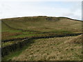
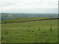
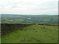
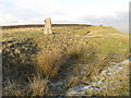
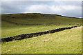
Nearby Images from Geograph Britain and Ireland:
©2005(licence)
©2012(licence)
©2012(licence)
©2013(licence)
©2016(licence)
The above images may not be of the site on this page, they are loaded from Geograph.
Please Submit an Image of this site or go out and take one for us!
Click here to see more info for this site
Nearby sites
Key: Red: member's photo, Blue: 3rd party photo, Yellow: other image, Green: no photo - please go there and take one, Grey: site destroyed
Download sites to:
KML (Google Earth)
GPX (GPS waypoints)
CSV (Garmin/Navman)
CSV (Excel)
To unlock full downloads you need to sign up as a Contributory Member. Otherwise downloads are limited to 50 sites.
Turn off the page maps and other distractions
Nearby sites listing. In the following links * = Image available
2.6km NE 53° Mount Famine burial cist* Cist (SK056852)
3.0km NE 42° Coldwell Clough Anglo Saxon cross Ancient Cross (SK055858)
3.1km SSE 159° Nanny Well* Holy Well or Sacred Spring (SK046807)
3.2km N 9° Watery Hey Well* Holy Well or Sacred Spring (SK0399986733)
3.2km NE 41° Fog Field Well* Holy Well or Sacred Spring (SK05578602)
3.2km NNE 16° Whitworth Well* Holy Well or Sacred Spring (SK0437786691)
3.2km NE 35° White Lady standing stone* Standing Stone (Menhir) (SK0534286250)
3.6km SE 141° St Thomas Becket (Chapel en le Frith)* Ancient Cross (SK0574580820)
3.7km SE 135° Nanny's Well (Chapel le Frith) Holy Well or Sacred Spring (SK061810)
3.8km NNE 32° Tunstead Clough* Ancient Village or Settlement (SK055868)
3.8km WSW 245° Ringstone (Whaley Bridge) Stone Circle (SK000820)
4.1km NNE 28° Upper Dole Field Well* Holy Well or Sacred Spring (SK054872)
4.2km WSW 240° Hawkhurst Head* Standing Stone (Menhir) (SJ99838149)
4.3km SSW 196° Ladder Hill* Ring Cairn (SK0230579434)
4.4km WSW 244° The Dipping Stone* Ancient Cross (SJ99558171)
4.4km SSW 205° The Shall Cross* Ancient Cross (SK0165579615)
4.7km ESE 114° Mag Low* Round Barrow(s) (SK078817)
4.9km ENE 59° Edale Cross* Ancient Cross (SK0772586092)
4.9km NE 51° Kinderlow Bowl Barrow* Round Barrow(s) (SK073867)
4.9km E 97° Green Low ringcairn* Ring Cairn (SK084830)
5.1km ESE 105° Ford Hall Cairn (SK084823)
5.4km SSE 160° Castle Naze* Hillfort (SK054785)
5.6km WSW 243° Stone near Higher Cornfield Farm* Standing Stone (Menhir) (SJ985811)
5.8km SSE 149° Cow Low* Round Barrow(s) (SK0653378666)
5.8km NE 48° Cluther Rocks* Ancient Mine, Quarry or other Industry (SK078875)
View more nearby sites and additional images


 We would like to know more about this location. Please feel free to add a brief description and any relevant information in your own language.
 Wir möchten mehr über diese Stätte erfahren. Bitte zögern Sie nicht, eine kurze Beschreibung und relevante Informationen in Deutsch hinzuzufügen.
 Nous aimerions en savoir encore un peu sur les lieux. S'il vous plaît n'hesitez pas à ajouter une courte description et tous les renseignements pertinents dans votre propre langue.
 Quisieramos informarnos un poco más de las lugares. No dude en añadir una breve descripción y otros datos relevantes en su propio idioma.