


<< Our Photo Pages >> Wall Roman sites (Letocetum) - Ancient Village or Settlement in England in Staffordshire
Submitted by Forest_Jungle_Collective on Wednesday, 06 September 2023 Page Views: 677
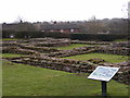
Roman, Greek and ClassicalSite Name: Wall Roman sites (Letocetum)Country: England
NOTE: This site is 4.713 km away from the location you searched for.
County: Staffordshire Type: Ancient Village or Settlement
Nearest Town: Lichfield Nearest Village: Wall
Map Ref: SK0977506660
Latitude: 52.657578N Longitude: 1.856925W
Condition:
| 5 | Perfect |
| 4 | Almost Perfect |
| 3 | Reasonable but with some damage |
| 2 | Ruined but still recognisable as an ancient site |
| 1 | Pretty much destroyed, possibly visible as crop marks |
| 0 | No data. |
| -1 | Completely destroyed |
| 5 | Superb |
| 4 | Good |
| 3 | Ordinary |
| 2 | Not Good |
| 1 | Awful |
| 0 | No data. |
| 5 | Can be driven to, probably with disabled access |
| 4 | Short walk on a footpath |
| 3 | Requiring a bit more of a walk |
| 2 | A long walk |
| 1 | In the middle of nowhere, a nightmare to find |
| 0 | No data. |
| 5 | co-ordinates taken by GPS or official recorded co-ordinates |
| 4 | co-ordinates scaled from a detailed map |
| 3 | co-ordinates scaled from a bad map |
| 2 | co-ordinates of the nearest village |
| 1 | co-ordinates of the nearest town |
| 0 | no data |
Internal Links:
External Links:
 (PID:262019)")
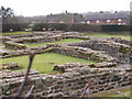
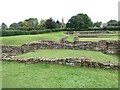
The mansio and bath house are the most important buildings in the town and are considered to be the best preserved examples surviving in England. Considerable amounts of archaeological information relating to the many aspects of Roman life at Letocetum are known to survive. The monument represents a very well preserved example of its type.
Source: https://historicengland.org.uk/listing/the-list/list-entry/1006108
Note: Wall Roman Site Museum Open Weekend, Sat/Sun 9/10th September
You may be viewing yesterday's version of this page. To see the most up to date information please register for a free account.
 (PID:262020)")
Do not use the above information on other web sites or publications without permission of the contributor.
Nearby Images from Geograph Britain and Ireland:
©2011(licence)
©2023(licence)
©2009(licence)
©2023(licence)
©2011(licence)
The above images may not be of the site on this page, they are loaded from Geograph.
Please Submit an Image of this site or go out and take one for us!
Click here to see more info for this site
Nearby sites
Key: Red: member's photo, Blue: 3rd party photo, Yellow: other image, Green: no photo - please go there and take one, Grey: site destroyed
Download sites to:
KML (Google Earth)
GPX (GPS waypoints)
CSV (Garmin/Navman)
CSV (Excel)
To unlock full downloads you need to sign up as a Contributory Member. Otherwise downloads are limited to 50 sites.
Turn off the page maps and other distractions
Nearby sites listing. In the following links * = Image available
4.4km NNE 34° St Chad's Well (Lichfield)* Holy Well or Sacred Spring (SK122103)
7.6km NW 313° Nun's Well (Cannock Wood)* Holy Well or Sacred Spring (SK04151180)
7.9km SE 140° St Modwen's Well (Canwell) Holy Well or Sacred Spring (SK14890058)
8.1km NW 320° Castle Ring (Staffordshire)* Hillfort (SK045128)
8.7km S 178° Druid's Well (Sutton Park) Holy Well or Sacred Spring (SP1016297991)
9.2km NNE 11° King's Bromley Cursus Cursus (SK116157)
9.5km NE 36° Alrewas Causewayed Enclosure* Causewayed Enclosure (SK15351436)
10.1km S 176° Keeper's Well* Holy Well or Sacred Spring (SP1049296613)
10.2km S 183° Rowton Well* Holy Well or Sacred Spring (SP0927496487)
10.2km N 353° Mavesyn Ridware* Causewayed Enclosure (SK0853816800)
11.0km N 353° Mavesyn Ridware Cursus Cursus (SK08471759)
11.0km N 353° Hill Ridware* Cursus (SK08471759)
11.0km W 266° The Great Stones of Landywood* Stone Circle (SJ9872805826)
11.2km S 189° The King's Standing* Round Barrow(s) (SP080956)
11.3km ESE 105° St Ruffin's Well (Tamworth)* Holy Well or Sacred Spring (SK207038)
11.4km NE 44° Alrewas and Fradley Cursus Cursus (SK177149)
11.4km NE 44° Alrewas Cursus* Cursus (SK177149)
11.8km NE 48° National Memorial Arboretum* Henge (SK18531459)
11.9km NNW 344° Cawarden Spring Holy Well or Sacred Spring (SK064181)
12.8km ENE 65° Stone in Croxall Churchyard* Marker Stone (SK2140512127)
13.9km NE 44° Catholme 02 Henge (SK19431670)
14.0km NE 45° Catholme 01* Timber Circle (SK19621666)
14.0km NE 43° Barton Under Needwood Cursus Cursus (SK19301697)
14.4km NE 43° Efflinch Cursus (SK19521724)
14.5km NNW 332° Bower Farm* Cave or Rock Shelter (SK030195)
View more nearby sites and additional images


 We would like to know more about this location. Please feel free to add a brief description and any relevant information in your own language.
 Wir möchten mehr über diese Stätte erfahren. Bitte zögern Sie nicht, eine kurze Beschreibung und relevante Informationen in Deutsch hinzuzufügen.
 Nous aimerions en savoir encore un peu sur les lieux. S'il vous plaît n'hesitez pas à ajouter une courte description et tous les renseignements pertinents dans votre propre langue.
 Quisieramos informarnos un poco más de las lugares. No dude en añadir una breve descripción y otros datos relevantes en su propio idioma.