

<< Text Pages >> Montmuran menhirs - Standing Stones in France in Bretagne:Ille-et-Vilaine (35)
Submitted by thecaptain on Saturday, 21 June 2008 Page Views: 2946
Neolithic and Bronze AgeSite Name: Montmuran menhirsCountry: France
NOTE: This site is 0.935 km away from the location you searched for.
Département: Bretagne:Ille-et-Vilaine (35) Type: Standing Stones
Nearest Town: Rennes Nearest Village: Les Iffs
Latitude: 48.293000N Longitude: 1.857W
Condition:
| 5 | Perfect |
| 4 | Almost Perfect |
| 3 | Reasonable but with some damage |
| 2 | Ruined but still recognisable as an ancient site |
| 1 | Pretty much destroyed, possibly visible as crop marks |
| 0 | No data. |
| -1 | Completely destroyed |
| 5 | Superb |
| 4 | Good |
| 3 | Ordinary |
| 2 | Not Good |
| 1 | Awful |
| 0 | No data. |
| 5 | Can be driven to, probably with disabled access |
| 4 | Short walk on a footpath |
| 3 | Requiring a bit more of a walk |
| 2 | A long walk |
| 1 | In the middle of nowhere, a nightmare to find |
| 0 | No data. |
| 5 | co-ordinates taken by GPS or official recorded co-ordinates |
| 4 | co-ordinates scaled from a detailed map |
| 3 | co-ordinates scaled from a bad map |
| 2 | co-ordinates of the nearest village |
| 1 | co-ordinates of the nearest town |
| 0 | no data |
Be the first person to rate this site - see the 'Contribute!' box in the right hand menu.
Internal Links:
External Links:
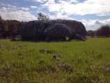
Two quartz menhirs can be found to the east of the village near to the Chateau de Montmuran.
One is 2.8 metres tall, the second is 1.9 metres tall.
You may be viewing yesterday's version of this page. To see the most up to date information please register for a free account.
Do not use the above information on other web sites or publications without permission of the contributor.
Nearby Images from Flickr
The above images may not be of the site on this page, but were taken nearby. They are loaded from Flickr so please click on them for image credits.
Click here to see more info for this site
Nearby sites
Click here to view sites on an interactive map of the areaKey: Red: member's photo, Blue: 3rd party photo, Yellow: other image, Green: no photo - please go there and take one, Grey: site destroyed
Download sites to:
KML (Google Earth)
GPX (GPS waypoints)
CSV (Garmin/Navman)
CSV (Excel)
To unlock full downloads you need to sign up as a Contributory Member. Otherwise downloads are limited to 50 sites.
Turn off the page maps and other distractions
Nearby sites listing. In the following links * = Image available
3.4km E 91° Cupules de Saint-Symphorien Rock Art
5.3km WSW 256° Les Pierres du Diable* Standing Stones
7.1km E 86° Bringnerault Alignement * Standing Stones
10.1km S 169° Roche des Basses Mordelles* Modern Stone Circle etc
10.2km S 170° Menhir des Basses Mardelles Standing Stone (Menhir)
13.8km N 8° Menhir du Grand-Herbage Standing Stone (Menhir)
14.6km ESE 109° Menhirs du Bas Couyet Standing Stones
15.2km W 269° La Roche Carrée* Standing Stone (Menhir)
15.4km W 270° Les Longs Points* Stone Row / Alignment
15.4km W 270° Clos du Rocher* Stone Row / Alignment
15.5km W 270° Bergeons* Stone Row / Alignment
15.6km W 270° Grande Epine* Stone Row / Alignment
15.6km W 271° Roche Longue de Guitté* Standing Stone (Menhir)
15.6km W 270° Alignement dit les Rochers (Lampouy)* Stone Row / Alignment
16.9km NE 41° Allée Couverte de Chevrot Passage Grave
18.5km NNE 13° Bourgneuf menhir Standing Stone (Menhir)
19.7km NE 44° Pierre Longue de Saint-Jouan* Standing Stone (Menhir)
19.9km NE 34° Menhir des Douères* Standing Stone (Menhir)
20.0km SSW 204° La Roche (Coulon)* Standing Stone (Menhir)
20.4km SSW 206° Coffre de Ty Bot* Cist
21.2km SSW 198° Gres de Saint-Meen dolmen* Standing Stone (Menhir)
21.4km N 356° La Maison des Feins* Passage Grave
22.3km NNW 339° La Ganterie* Passage Grave
23.2km SSW 212° Pierre Longue (Iffendic)* Standing Stone (Menhir)
23.2km N 349° Four-És-Feins* Passage Grave
View more nearby sites and additional images


 We would like to know more about this location. Please feel free to add a brief description and any relevant information in your own language.
 Wir möchten mehr über diese Stätte erfahren. Bitte zögern Sie nicht, eine kurze Beschreibung und relevante Informationen in Deutsch hinzuzufügen.
 Nous aimerions en savoir encore un peu sur les lieux. S'il vous plaît n'hesitez pas à ajouter une courte description et tous les renseignements pertinents dans votre propre langue.
 Quisieramos informarnos un poco más de las lugares. No dude en añadir una breve descripción y otros datos relevantes en su propio idioma.