 with our Megalithic Portal iPhone app")


<< Our Photo Pages >> St Cuthbert's Well (Mitford) - Holy Well or Sacred Spring in England in Northumberland
Submitted by Anne T on Wednesday, 24 October 2018 Page Views: 2190
Springs and Holy WellsSite Name: St Cuthbert's Well (Mitford) Alternative Name: Mitford FountainCountry: England
NOTE: This site is 2.97 km away from the location you searched for.
County: Northumberland Type: Holy Well or Sacred Spring
Nearest Town: Morpeth Nearest Village: Mitford
Map Ref: NZ1720685990
Latitude: 55.167927N Longitude: 1.731443W
Condition:
| 5 | Perfect |
| 4 | Almost Perfect |
| 3 | Reasonable but with some damage |
| 2 | Ruined but still recognisable as an ancient site |
| 1 | Pretty much destroyed, possibly visible as crop marks |
| 0 | No data. |
| -1 | Completely destroyed |
| 5 | Superb |
| 4 | Good |
| 3 | Ordinary |
| 2 | Not Good |
| 1 | Awful |
| 0 | No data. |
| 5 | Can be driven to, probably with disabled access |
| 4 | Short walk on a footpath |
| 3 | Requiring a bit more of a walk |
| 2 | A long walk |
| 1 | In the middle of nowhere, a nightmare to find |
| 0 | No data. |
| 5 | co-ordinates taken by GPS or official recorded co-ordinates |
| 4 | co-ordinates scaled from a detailed map |
| 3 | co-ordinates scaled from a bad map |
| 2 | co-ordinates of the nearest village |
| 1 | co-ordinates of the nearest town |
| 0 | no data |
Internal Links:
External Links:
I have visited· I would like to visit
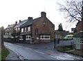
Anne T visited on 24th Oct 2018 - their rating: Cond: 3 Amb: 3 Access: 5 Site of St Cuthbert's Holy Well, Mitford: After having visited Bothal church and spent well over an hour looking around, we stopped off at The Old Chantry tea rooms in Morpeth for a bowl of soup and a cup of tea, then headed off to the small, but very pretty village of Mitford, just over 2.5 km west of Morpeth.
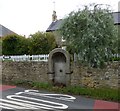
OK, so there is no longer a well here, and the Victorian-era drinking fountain structure that was built in the place where the well was supposed to have been is now dry, it was easy to find. The road is reasonably busy, so I risked getting run over to get a few close up shots. The carving of the impaled dragon's head (I didn't realise what it was until I saw the photos on the larger screen of the computer and read the Historic England description) was pretty gruesome.
We did wander down to the river and walked along a little way. Someone has built what appears to be a very pretty, but very modern, thatched cottage by the side of the footpath along the river.
Note for next time: the pub does special offers on food for pensioners!
 (PID:187394)")
Considering it is almost Halloween, the description of 'there was a scared well in Mitford', is almost appropriate - see Pastscape Monument No. 23254; this should really read 'sacred' well, but isn't such fun, although 'scared' may reference the carving of the impaled dragon (see below)!
We found reference to this well originally in "Holy Wells in Northumberland and Durham: Binnall & Dodds, 1941, page 67" (Proceedings of Society of Antiquities, Newcastle upon Tyne). This document talks about Reginald of Durham's "Miracles of St Cuthbert' in which he records a miracle involving part of the shroud of St Cuthbert which was supposed to have occurred at the well in 1006.
In 1827, the antiquarian and historian Hodgson was unable to find this well, but "when the Berwickshire Naturalists Club visited Mitford in 1880 they found that Colonel Mitford had erected a stone fountain on the supposed scene of the miracle." Historic England makes reference to this in their entry for List ID 1042682
Historic England adds: "What remains of his stone fountain is its rounded headed arch, which encloses a relief carving of a dragon's head impaled on a sword and a spout plate."
The well housing is built into the wall of the Old Post Office, to the northern side of the B6343, approaching the village from Morpeth, just before its junction with Font Side with the Old Blacksmith's Cottage on the corner.
You may be viewing yesterday's version of this page. To see the most up to date information please register for a free account.
 (PID:187395)")
 (PID:187393)")
 (PID:187392)")
Do not use the above information on other web sites or publications without permission of the contributor.
Nearby Images from Geograph Britain and Ireland:
©2014(licence)
©2007(licence)
©2007(licence)
©2016(licence)
©2014(licence)
The above images may not be of the site on this page, they are loaded from Geograph.
Please Submit an Image of this site or go out and take one for us!
Click here to see more info for this site
Nearby sites
Key: Red: member's photo, Blue: 3rd party photo, Yellow: other image, Green: no photo - please go there and take one, Grey: site destroyed
Download sites to:
KML (Google Earth)
GPX (GPS waypoints)
CSV (Garmin/Navman)
CSV (Excel)
To unlock full downloads you need to sign up as a Contributory Member. Otherwise downloads are limited to 50 sites.
Turn off the page maps and other distractions
Nearby sites listing. In the following links * = Image available
6.2km NW 325° Clavering's Cross* Ancient Cross (NZ1359691047)
6.8km E 85° St Andrew's Church (Bothal)* Ancient Cross (NZ2398986621)
8.1km WNW 301° Netherwitton Hall* Round Cairn (NZ1022990218)
8.6km WSW 247° St Andrew's Church (Bolam)* Ancient Cross (NZ0924482601)
8.6km WSW 244° Bolam Round Cairn (Northumberland)* Round Cairn (NZ0940082226)
8.7km NE 44° Ulgham Cross* Ancient Cross (NZ2321892308)
8.9km WNW 301° Five Ashes Cairn (Netherwitton)* Round Cairn (NZ0956490611)
9.1km WNW 303° Netherwitton B* Round Cairn (NZ0956390932)
9.2km WNW 303° Netherwitton A* Round Cairn (NZ0938090925)
9.6km ESE 115° Bedlington Market Cross* Ancient Cross (NZ2594981924)
9.8km ESE 116° St Cuthbert's Church (Bedlington)* Sculptured Stone (NZ2605081813)
9.8km WSW 243° Bolam Rock Art Panel Rock Art (NZ0850081500)
10.2km WSW 238° Shortflatt Barrow* Round Barrow(s) (NZ08518057)
10.3km WSW 239° Shortflatt b & d Rock Art (NZ08358060)
10.4km WSW 238° Shortflatt c Rock Art (NZ0829380491)
10.5km WSW 242° Shortflatt a Rock Art (NZ0792080995)
11.0km SE 143° Northumberlandia* Modern Stone Circle etc (NZ2384777182)
11.1km WSW 250° The Poind and Man Rock Art Rock Art (NZ0673282136)
11.3km WSW 250° The Poind And His Man* Standing Stone (Menhir) (NZ06578210)
11.3km SW 229° Belsay Tower Cross (Northumberland)* Ancient Cross (NZ0867178552)
11.5km ESE 115° Bebside Road Henge Henge (NZ277812)
11.6km WSW 250° Poind and Man (West)* Rock Art (NZ0629582043)
11.7km WSW 255° Middleton Bank Top 1c Rock Art (NZ0583882943)
11.7km WSW 255° Middleton Bank Top 1a* Rock Art (NZ0583682943)
11.7km WSW 255° Middleton Bank Top 1b & N1b* Rock Art (NZ0583582945)
View more nearby sites and additional images


 We would like to know more about this location. Please feel free to add a brief description and any relevant information in your own language.
 Wir möchten mehr über diese Stätte erfahren. Bitte zögern Sie nicht, eine kurze Beschreibung und relevante Informationen in Deutsch hinzuzufügen.
 Nous aimerions en savoir encore un peu sur les lieux. S'il vous plaît n'hesitez pas à ajouter une courte description et tous les renseignements pertinents dans votre propre langue.
 Quisieramos informarnos un poco más de las lugares. No dude en añadir una breve descripción y otros datos relevantes en su propio idioma.