

<< Our Photo Pages >> Dethick Moor - Stone Circle in England in Derbyshire
Submitted by david-p on Sunday, 17 October 2021 Page Views: 8209
Date UncertainSite Name: Dethick MoorCountry: England County: Derbyshire Type: Stone Circle
Nearest Town: Matlock Nearest Village: Tansley
Map Ref: SK3459 Landranger Map Number: 119
Latitude: 53.127089N Longitude: 1.493346W
Condition:
| 5 | Perfect |
| 4 | Almost Perfect |
| 3 | Reasonable but with some damage |
| 2 | Ruined but still recognisable as an ancient site |
| 1 | Pretty much destroyed, possibly visible as crop marks |
| 0 | No data. |
| -1 | Completely destroyed |
| 5 | Superb |
| 4 | Good |
| 3 | Ordinary |
| 2 | Not Good |
| 1 | Awful |
| 0 | No data. |
| 5 | Can be driven to, probably with disabled access |
| 4 | Short walk on a footpath |
| 3 | Requiring a bit more of a walk |
| 2 | A long walk |
| 1 | In the middle of nowhere, a nightmare to find |
| 0 | No data. |
| 5 | co-ordinates taken by GPS or official recorded co-ordinates |
| 4 | co-ordinates scaled from a detailed map |
| 3 | co-ordinates scaled from a bad map |
| 2 | co-ordinates of the nearest village |
| 1 | co-ordinates of the nearest town |
| 0 | no data |
Internal Links:
External Links:
I have visited· I would like to visit
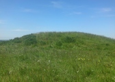
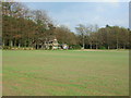
david-p visited on 20th Aug 2021 - their rating: Cond: 1 Amb: 3 I have put some drone photos of this site taken by a very kind drone pilot. Very random photos as there are not so many points we could pinpoint.
Anyone who visited this site as the old Car Boot Market will possibly know that this area has quite large stones in the ground. I wonder if these are fallen stones, random stones or moved stones. They do look flat and slightly shaped?
I welcome any knowledge of people that know where exactly to point the drone
Slightly further down the track there are 2 small ground depressions which could be part of the circles or the area where stones were removed. On one is a perfect circle which could just be sheep tracks.
From ground level - nothing of note except those huge stones
")
I welcome any knowledge of people that know where exactly to point the drone Slightly further down the track there are 2 small ground depressions which could be part of the circles or the area where stones were removed. On one is a perfect circle which could just be sheep tracks. From ground level - nothing of note except those huge stones
Page originally by Vicky
You may be viewing yesterday's version of this page. To see the most up to date information please register for a free account.
")
")
")
")
Do not use the above information on other web sites or publications without permission of the contributor.
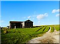
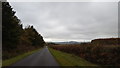
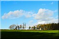
Nearby Images from Geograph Britain and Ireland:
©2024(licence)
©2019(licence)
©2024(licence)
©2008(licence)
©2019(licence)
The above images may not be of the site on this page, they are loaded from Geograph.
Please Submit an Image of this site or go out and take one for us!
Click here to see more info for this site
Nearby sites
Key: Red: member's photo, Blue: 3rd party photo, Yellow: other image, Green: no photo - please go there and take one, Grey: site destroyed
Download sites to:
KML (Google Earth)
GPX (GPS waypoints)
CSV (Garmin/Navman)
CSV (Excel)
To unlock full downloads you need to sign up as a Contributory Member. Otherwise downloads are limited to 50 sites.
Turn off the page maps and other distractions
Nearby sites listing. In the following links * = Image available
4.1km NW 321° Cuckoo Stone (Derbyshire)* Natural Stone / Erratic / Other Natural Feature (SK314622)
4.4km N 11° Ashover School* Rock Art (SK348633)
4.8km WSW 257° Peat Well* Holy Well or Sacred Spring (SK293579)
5.7km NW 315° Farley Moor Stone* Standing Stone (Menhir) (SK29966300)
5.8km NNW 328° Seven Brideron Stone Circle (SK309639)
6.2km SW 220° Wirksworth Moor* Standing Stone (Menhir) (SK3003454224)
7.2km SW 214° Wirksworth Moor circle Stone Circle (SK3053)
7.3km SW 226° St Mary the Virgin (Wirksworth)* Early Christian Sculptured Stone (SK2874853942)
7.3km SW 231° Stardisc Wirksworth* Modern Stone Circle etc (SK2835654381)
7.3km SW 227° St Mary's Churchyard Cross (Wirksworth)* Ancient Cross (SK2872353963)
8.0km W 268° Horsedale Standing Stone* Standing Stone (Menhir) (SK2601558596)
8.1km SW 234° The Bradstone* Standing Stone (Menhir) (SK2740054207)
8.3km WNW 299° St Helen’s Church (Darley Dale)* Carving (SK26676298)
8.7km NW 321° Woodbrook Quarry Stone Circle (SK28496573)
9.0km WSW 247° Round Low (Hopton) Round Barrow(s) (SK2572955426)
9.2km WSW 241° Ivet Low* Round Barrow(s) (SK2596254396)
9.4km NW 318° Fallinge Edge* Ring Cairn (SK277660)
9.7km WNW 297° Cat Stone* Rock Outcrop (SK253633)
9.7km WNW 294° Gorse Stone* Rock Outcrop (SK251629)
9.8km NNW 344° Longside Moor* Cairn (SK313684)
9.8km WNW 296° Stanton Moor Cairn T57* Cairn (SK25136331)
9.8km NW 323° Beeley Triple Cairn* Ring Cairn (SK2800366824)
9.9km N 349° Holymoorside* Rock Art (SK321687)
10.0km WNW 293° Stanton Moor Cairn (TBC)* Cairn (SK2467562791)
10.0km WNW 295° Stanton Moor Cairn T55* Round Cairn (SK24826313)
View more nearby sites and additional images


 We would like to know more about this location. Please feel free to add a brief description and any relevant information in your own language.
 Wir möchten mehr über diese Stätte erfahren. Bitte zögern Sie nicht, eine kurze Beschreibung und relevante Informationen in Deutsch hinzuzufügen.
 Nous aimerions en savoir encore un peu sur les lieux. S'il vous plaît n'hesitez pas à ajouter une courte description et tous les renseignements pertinents dans votre propre langue.
 Quisieramos informarnos un poco más de las lugares. No dude en añadir una breve descripción y otros datos relevantes en su propio idioma.