Featured: Explore Scotland (and everywhere else) with our Megalithic Portal iPhone app

Explore Scotland (and everywhere else) with our Megalithic Portal iPhone app

Random Image


Kings Stanley Dyke

Stonehenge Sacred Symbolism - Ancient Beliefs in Britain and Northern Europe

Stonehenge Sacred Symbolism - Ancient Beliefs in Britain and Northern Europe

Who's Online

There are currently, 181 guests and 1 members online.

You are a guest. To join in, please register for free by clicking here

Sponsors

<< Other Photo Pages >> Barwick in Elmet Hillfort - Hillfort in England in Yorkshire (West)

Submitted by Andy B on Tuesday, 03 September 2013  Page Views: 12758

Iron Age and Later PrehistorySite Name: Barwick in Elmet Hillfort
Country: England
NOTE: This site is 3.82 km away from the location you searched for.

County: Yorkshire (West) Type: Hillfort
Nearest Town: Leeds  Nearest Village: Barwick in Elmet
Map Ref: SE398375
Latitude: 53.832242N  Longitude: 1.396752W
Condition:
5Perfect
4Almost Perfect
3Reasonable but with some damage
2Ruined but still recognisable as an ancient site
1Pretty much destroyed, possibly visible as crop marks
0No data.
-1Completely destroyed
2 Ambience:
5Superb
4Good
3Ordinary
2Not Good
1Awful
0No data.
3 Access:
5Can be driven to, probably with disabled access
4Short walk on a footpath
3Requiring a bit more of a walk
2A long walk
1In the middle of nowhere, a nightmare to find
0No data.
4 Accuracy:
5co-ordinates taken by GPS or official recorded co-ordinates
4co-ordinates scaled from a detailed map
3co-ordinates scaled from a bad map
2co-ordinates of the nearest village
1co-ordinates of the nearest town
0no data
4

Internal Links:
External Links:

Barwick in Elmet Hillfort
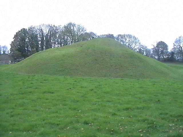
Barwick in Elmet Hillfort submitted by Creative Commons : Hall Tower Hill from northern edge of the site. Its height is about 50ft. There is a ditch between the camera and the hill. This is presumably the motte. See the other image for the prehistoric ramparts. Copyright BC and licensed for reuse under the Creative Commons Licence. (Vote or comment on this photo)
Barwick in Elmet comprises the earthwork and buried remains of a large Iron Age univallate hillfort and a twelfth century motte and bailey castle. After the Roman period it may have been the chief stronghold of the Kingdom of Elmet.

The Iron Age hillfort encloses the summits of two adjacent hills;Wendel Hill and Hall Tower Hill. Substantial remains of the hillfort's enclosing bank and ditch have survived on Wendel Hill (up to 4.5m high from base to summit) and on the south-west part of Hall Tower Hill; though these were modified in the 12th century.

The south circuit of the bank and ditch, on the south side of Hall Tower Hill, was also identified during construction work in the 1960s. The remains of a massive inturned entrance are visible on the north-west side of Wendel Hill, and much of the interior of the hillfort has survived. Various finds have been uncovered including coins dating to the second century BC and first century AD.

More at Pastscape

Note: Guided tours of this largely unvisited hill fort with Norman fortifications inside it. Fri 13th/Sat 14th September
You may be viewing yesterday's version of this page. To see the most up to date information please register for a free account.
Barwick in Elmet Hillfort
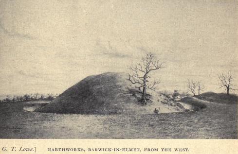
Barwick in Elmet Hillfort submitted by durhamnature : Old drawing from "Old Kingdom of Elmet" via archive.org (Vote or comment on this photo)

Barwick in Elmet Hillfort
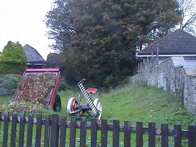
Barwick in Elmet Hillfort submitted by Creative Commons : Hall Tower Hill - Southern, Outer Rampart. The path goes round Hall Tower Hill's southern and western rampart. Copyright BC and licensed for reuse under the Creative Commons Licence. (Vote or comment on this photo)

Barwick in Elmet Hillfort
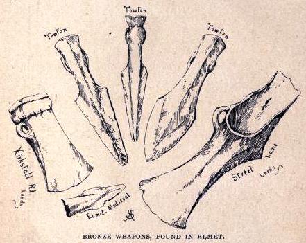
Barwick in Elmet Hillfort submitted by durhamnature : Weapon finds, from "Old Kingdom of Elmet" via archive.org (Vote or comment on this photo)

Do not use the above information on other web sites or publications without permission of the contributor.

Nearby Images from Geograph Britain and Ireland:
SE3937 : View south-east from Hall Tower Hill, Barwick-in-Elmet  by Stephen Craven
by Stephen Craven
©2019(licence)
SE3937 : Hall Tower Hill - Northern Aspect by BC
by BC
©2011(licence)
SE3937 : Hall Tower Hill - Western Aspect by BC
by BC
©2011(licence)
SE3937 : Hall Tower Hill - Southern Aspect by BC
by BC
©2011(licence)
SE3937 : Hall Tower Hill, Barwick in Elmet by Gordon Hatton
by Gordon Hatton
©2018(licence)

The above images may not be of the site on this page, they are loaded from Geograph.
Please Submit an Image of this site or go out and take one for us!


Click here to see more info for this site

Nearby sites

Click here to view sites on an interactive OS map

Key: Red: member's photo, Blue: 3rd party photo, Yellow: other image, Green: no photo - please go there and take one, Grey: site destroyed

Download sites to:
KML (Google Earth)
GPX (GPS waypoints)
CSV (Garmin/Navman)
CSV (Excel)

To unlock full downloads you need to sign up as a Contributory Member. Otherwise downloads are limited to 50 sites.


Turn off the page maps and other distractions

Nearby sites listing. In the following links * = Image available
 3.5km E 96° St Ricarius (Aberford) Ancient Cross (SE4331037170)
 4.0km W 278° Grim's Dyke* Misc. Earthwork (SE358380)
 6.5km NNW 331° All Hallows (Bardsey)* Ancient Cross (SE3656143122)
 7.2km W 264° Gipton Wood Ancient Village or Settlement (SE32653664)
 8.1km E 98° Saxton Church Ancient Cross (SE478364)
 8.6km N 355° Collingham Crosses* Ancient Cross (SE3901546096)
 9.7km NE 40° Newton Kyme Henge Henge (SE45934499)
 9.7km WSW 247° Quarry Hill (Leeds) Ancient Village or Settlement (SE309336)
 9.8km ESE 114° Sherburn Cross* Ancient Cross (SE488335)
 9.9km NNE 33° St Helen's Well (Boston Spa)* Holy Well or Sacred Spring (SE45134583)
 9.9km WSW 248° Lady Well (Leeds) Holy Well or Sacred Spring (SE30603373)
 10.0km NW 304° Grey Stone (Harewood)* Rock Art (SE31474308)
 10.0km WSW 246° St Peter's Minster Church (Kirkgate) Ancient Cross (SE30653330)
 11.3km WSW 246° St Helen's Well (Holbeck) Holy Well or Sacred Spring (SE295329)
 11.3km ENE 72° St John the Baptist (Kirkby Wharfe) Ancient Cross (SE50604107)
 11.6km WSW 254° Gray Stone (Burley) Natural Stone / Erratic / Other Natural Feature (SE2865934229)
 12.7km WNW 283° Adel Cupstone* Rock Art (SE274402)
 13.8km N 357° Green Howe (North Deighton) Round Barrow(s) (SE38865124)
 13.9km NNW 328° St Helen's Well (Kirkby Overblow)* Holy Well or Sacred Spring (SE32354920)
 14.4km S 173° Featherstone Cursus Cursus (SE418232)
 15.0km SSE 150° Angel Moon Field Cairn (SE47342449)
 15.1km NNE 32° St Helen's Church (Bilton-in-Ainsty)* Ancient Cross (SE476504)
 15.1km SSE 151° Round Hill Field (Ferrybridge) Cairn (SE47332444)
 15.2km WNW 285° Long Stone (Adel) Standing Stone (Menhir) (SE25014119)
 15.3km SSE 151° Ferrybridge Henge Henge (SE47462424)
View more nearby sites and additional images

<< La Ciudad Blanca

Hessisches Landesmuseum Kassel >>

Please add your thoughts on this site

Build your own Stonehenge! (Model)

Build your own Stonehenge! (Model)

Sponsors

Auto-Translation (Google)

Translate from English into:

"Barwick in Elmet Hillfort" | Login/Create an Account | 13 News and Comments
  
Go back to top of page    Comments are owned by the poster. We aren't responsible for their content.
Re: Barwick-in-Elmet and King Arthur by AngieLake on Wednesday, 04 April 2018
(User Info | Send a Message)
Article here with many photos:
http://www.dailymail.co.uk/sciencetech/article-5572831/Was-King-Arthur-born-village-near-LEEDS.html
[ Reply to This ]

Barwick-in-Elmet Hillfort tours, Fri 13th/Sat 14th September by Andy B on Tuesday, 03 September 2013
(User Info | Send a Message)
Hall Tower Field, Barwick-in-Elmet, Leeds, West Yorkshire, LS15

An Iron age Hillfort, covering about 15 acres which is still largely intact. Within the hillfort is a Norman Motte and Bailey. The tour takes about one hour and involves climbing stiles, so stout footware is advised.

There is a video lasting over 14 minutes which will give an idea of what can be seen.
http://www.youtube.com/watch?v=X_vuYpzjaCk

Children are very welcome.
Opening Times Friday 13th September: 1100-1600 Saturday 14th September: 1100-1600

Access The tour involves climbing steps and stiles. It also covers country footpaths.

The tour starts at the village church which is also open for visits.

Directions Assemble at All saints Church in the centre of Barwick-in-Elmet -
See more at: http://www.heritageopendays.org.uk/directory/barwick-in-elmet-iron-age-hillfort#sthash.Sa2RpoIk.dpuf
and
http://barwickinelmethistoricalsociety.com/bhs.html
[ Reply to This ]

Re: Barwick-in-Elmet Historical Society by Anonymous on Sunday, 18 August 2013
For many years through the 80 and 90'smaintenance work carried out by volunteers with restrictions enforced by the National Heritage.
trees were not allowed to be removed. However, only small bushes brambles and immature Hawthorn were to Be found on the Motte, Mature trees lined the boundaries and but for the rules, neighbouring property owners also resisted any ideas of tree reduction .
In the 80's the existing maypole committee were taken to task by the local authority for attempting to reduce tree cover.
[ Reply to This ]

Barwick in Elmet Hillfort Tour, 7/8th September 2012 by Andy B on Friday, 07 September 2012
(User Info | Send a Message)
Hall Tower Field, Barwick in Elmet, Leeds, West Yorkshire

[Please could you take some photos for us if you're visiting! - MegP Ed]

Guided tour of this largely unvisited hill fort with its Norman fortifications inside it. The fort is ‘hidden' in the centre of the old village. Tours last approx 60 mins and begin every 30 minutes.
Opening Times

Friday 7th September: 1100 - 1600
Saturday 8th September: 1100 - 1600

Access

The full tour involves steep climbs and stiles. Special short tours available for people who cannot climb steps or stiles.
Additional information

Refreshments and toilets available at the church. Lunches are available in adjacent local public houses. Stout footwear is advised. For further information see the pastscape website: http://www.pastscape.org.uk/hob.aspx?hob_id=52862. The tour is arranged in association with the tours in All Saints Church.

Directions

Meet at All Saints Church, Barwick-in-Elmet 100m e of the maypole. 2 m S of A64, 2 m N of M1 (J47). Park on surrounding streets. BUS - 64 Leeds-Aberford; alight at the maypole. Grid reference: SE39893769
Organised by

Barwick-in-Elmet Historical Society
Website

http://www.barwickinelmethistoricalsociety.com
[ Reply to This ]

Re: Barwick in Elmet Hillfort by Anonymous on Monday, 07 November 2011
I have added photos in Geographia 7/11/201.
[ Reply to This ]

Re: Barwick-in-Elmet Historical Society by Andy B on Thursday, 08 September 2011
(User Info | Send a Message)
Well misleading the House of Commons is a very serious offence, tut tut! :)
[ Reply to This ]

Re: Barwick-in-Elmet Historical Society by Orme on Thursday, 08 September 2011
(User Info | Send a Message)
Andy B

Best not to believe what an MP says! Barwick in Elmet was part of a feudal holding, the Honour of Pontefract, the centre of which was the much bigger neighbouring Pontefract Castle. Both castles were built by Ilbert de Lacy. So if anywhere might be classed as a 'Tower of London in West Yorkshire' then it would be dear old Pomfret castle which was and remains the heart of the the Honour of Pontefract (now held by the Duchy of Lancaster).

Barwick in Elmet also has an ancient Maypole tradition with festival taking place every third year late in May.
[ Reply to This ]

Re: Barwick-in-Elmet Historical Society by Anonymous on Sunday, 04 September 2011
Streeview -
View Larger Map
[ Reply to This ]

Re: Barwick-in-Elmet Historical Society by Sunny100 on Sunday, 04 September 2011
(User Info | Send a Message)
Think this will be a place to go for Brigantia and TNA members. The ancient kingdom of Elmet - Barwick [Berwick] and Sherburne. Everyone welcome - even Southerners !! That's better I can't spell properly.
[ Reply to This ]
    Re: Barwick-in-Elmet hillfort by Andy B on Sunday, 04 September 2011
    (User Info | Send a Message)
    Sounds good - we didn't even have it listed until I saw this event. Photos much appreciated.
    [ Reply to This ]

Barwick in Elmet Hill Fort's moment of fame (?) in the House of Commons by Andy B on Sunday, 04 September 2011
(User Info | Send a Message)
There are very few examples of such iron age hill forts in Yorkshire, so Barwick is in a fortunate position. It is worth noting that the fort is considered to be large compared with others in Britain. As a footnote I add that the other similar fort is in Huddersfield, which does not even rank alongside Leeds. In addition, the earth works have a well-preserved Norman motte and bailey, of which there are roughly 600 nationally. That Norman motte and bailey is constructed in the iron age hill fort. It is history built on history.

To add another little footnote, the people who were responsible for building the Norman construction were the De Lacy family, who ruled a huge part of west Yorkshire from that particular monument, as we call it now, in Barwick. In some respects, Barwick in Elmet was the tower of London of west Yorkshire. The combination of the iron age and the Norman makes the Barwick site doubly important and fully deserving of efforts to protect and enhance it. The role of the Barwick in Elmet historical society has been absolutely crucial and critical in doing just that.

More at
http://www.theyworkforyou.com/debates/?id=2007-07-10b.1421.0
[ Reply to This ]
    Re: Barwick in Elmet Hill Fort's moment of fame (?) in the House of Commons by Anonymous on Sunday, 18 August 2013
    Barwick in elmet historical society were never crucial in preserving hall tower field. In recent times they have taken up an interest in helping to raise the profile of this national monument but no more than that.
    It was through the efforts of the old Maypole committee, who raised finance to purchase the site and protect it from possible development during the 70's that was crucial in its preservation
    [ Reply to This ]

Barwick-in-Elmet Historical Society by Andy B on Sunday, 04 September 2011
(User Info | Send a Message)
More details from the Barwick-in-Elmet Historical Society

The monument has suffered as the result of a long period of neglect. This is due in the main to the lack of awareness of many of the inhabitants and further afield of the importance of the monument. Apart from the periodic grass cutting in Hall Tower field (the field containing the norman part of the monument), there has been little maintenance of the rest of the ditches and banks. The (mainly) sycamore trees which outline the iron age perimeter of the earthworks have grown through default. Some have fallen and torn out the banking. (Two more have been blown down in 2007 and one more in 2008 with major damage to the banks of the earthworks.) The trees hide the spectacular nature of the hard work of the iron age inhabitants who created the hillfort with few tools and much hard labour.

http://www.barwickinelmethistoricalsociety.com/hillfort.html

Archeaological investigation - Our Hillfort Mystery unfolded?

http://www.barwickinelmethistoricalsociety.com/8230.html

[ Reply to This ]

Your Name: Anonymous [ Register Now ]
Subject:


Add your comment or contribution to this page. Spam or offensive posts are deleted immediately, don't even bother

<<< What is five plus one as a number? (Please type the answer to this question in the little box on the left)
You can also embed videos and other things. For Youtube please copy and paste the 'embed code'.
For Google Street View please include Street View in the text.
Create a web link like this: <a href="https://www.megalithic.co.uk">This is a link</a>  

Allowed HTML is:
<p> <b> <i> <a> <img> <em> <br> <strong> <blockquote> <tt> <li> <ol> <ul> <object> <param> <embed> <iframe>

We would like to know more about this location. Please feel free to add a brief description and any relevant information in your own language.
Wir möchten mehr über diese Stätte erfahren. Bitte zögern Sie nicht, eine kurze Beschreibung und relevante Informationen in Deutsch hinzuzufügen.
Nous aimerions en savoir encore un peu sur les lieux. S'il vous plaît n'hesitez pas à ajouter une courte description et tous les renseignements pertinents dans votre propre langue.
Quisieramos informarnos un poco más de las lugares. No dude en añadir una breve descripción y otros datos relevantes en su propio idioma.