 with our Megalithic Portal iPhone app")


<< Our Photo Pages >> Bob's Rock - Rock Outcrop in England in Nottinghamshire
Submitted by ESgt on Friday, 18 January 2013 Page Views: 10421
Natural PlacesSite Name: Bob's RockCountry: England
NOTE: This site is 0.983 km away from the location you searched for.
County: Nottinghamshire Type: Rock Outcrop
Nearest Town: Stapleford
Map Ref: SK4927937319
Latitude: 52.931022N Longitude: 1.268332W
Condition:
| 5 | Perfect |
| 4 | Almost Perfect |
| 3 | Reasonable but with some damage |
| 2 | Ruined but still recognisable as an ancient site |
| 1 | Pretty much destroyed, possibly visible as crop marks |
| 0 | No data. |
| -1 | Completely destroyed |
| 5 | Superb |
| 4 | Good |
| 3 | Ordinary |
| 2 | Not Good |
| 1 | Awful |
| 0 | No data. |
| 5 | Can be driven to, probably with disabled access |
| 4 | Short walk on a footpath |
| 3 | Requiring a bit more of a walk |
| 2 | A long walk |
| 1 | In the middle of nowhere, a nightmare to find |
| 0 | No data. |
| 5 | co-ordinates taken by GPS or official recorded co-ordinates |
| 4 | co-ordinates scaled from a detailed map |
| 3 | co-ordinates scaled from a bad map |
| 2 | co-ordinates of the nearest village |
| 1 | co-ordinates of the nearest town |
| 0 | no data |
Internal Links:
External Links:
I have visited· I would like to visit
elad13 visited on 4th Jan 2022 - their rating: Cond: 3 Amb: 5 Access: 3 A nice fairly hidden local site
")
The name is said to derive from an 11 century Norman land owner, Robert de Heriz.
Visited with local historian Frank Earp and Nottingham University Engineering Dep't members. Access, with the permission of the farmer, is from the Cemetery on Cemetery Road, or through the gardens of properties on the odd numbered side. The disturbed surroundings had been a brick yard at some time in the recent past.
The south side has three recesses; one large, two small, and there's another on the north side which has brick walling to it. Standing upon the top of the rock, at an elevation of 62m, gives a panoramic view of the landscape over to the south, west and north. The spire of Stapleford's St. Helen's Church was seen to be on a bearing of 279°, what was probably an equinox alignment in the Neolithic perioid.
You may be viewing yesterday's version of this page. To see the most up to date information please register for a free account.
")
")
")
")
Do not use the above information on other web sites or publications without permission of the contributor.
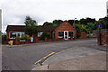
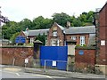
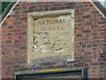
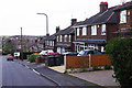
Nearby Images from Geograph Britain and Ireland:
©2016(licence)
©2018(licence)
©2018(licence)
©2015(licence)
©2012(licence)
The above images may not be of the site on this page, they are loaded from Geograph.
Please Submit an Image of this site or go out and take one for us!
Click here to see more info for this site
Nearby sites
Key: Red: member's photo, Blue: 3rd party photo, Yellow: other image, Green: no photo - please go there and take one, Grey: site destroyed
Download sites to:
KML (Google Earth)
GPX (GPS waypoints)
CSV (Garmin/Navman)
CSV (Excel)
To unlock full downloads you need to sign up as a Contributory Member. Otherwise downloads are limited to 50 sites.
Turn off the page maps and other distractions
Nearby sites listing. In the following links * = Image available
378m W 268° Stapleford Cross* Ancient Cross (SK489373)
1.3km ENE 57° Crow Hill Standing Stone* Standing Stone (Menhir) (SK50403805)
1.5km NNE 27° The Hemlock Stone* Rock Outcrop (SK4995538661)
1.7km N 5° Healing Spring* Holy Well or Sacred Spring (SK494390)
4.2km SSE 154° Conies Farm Stone Circle* Stone Circle (SK5115033599)
4.5km NNE 20° Catstone Hill* Natural Stone / Erratic / Other Natural Feature (SK50754156)
5.4km SE 127° Cliffton Woods Well* Holy Well or Sacred Spring (SK5361134124)
5.6km WNW 284° Hermit's Well (Dale Abbey) Holy Well or Sacred Spring (SK43783861)
6.0km ESE 104° Clifton Pile Settlements* Ancient Village or Settlement (SK5513735946)
6.3km W 277° Dale Hermitage* Cave or Rock Shelter (SK4338)
6.8km SSW 193° Sawley earthwork* Misc. Earthwork (SK4781130639)
7.4km ENE 75° Rock Chapel of St Mary* Cave or Rock Shelter (SK56433926)
7.9km ENE 75° Nottingham Castle Museum Museum (SK569394)
8.1km NE 49° Holy Well (Basford) Holy Well or Sacred Spring (SK553427)
8.3km N 5° Holy Well (Watnall)* Holy Well or Sacred Spring (SK499456)
8.9km SSW 196° Lockington Cursus Cursus (SK469287)
9.5km WSW 257° Saxon Holy Well* Holy Well or Sacred Spring (SK4035)
9.6km W 262° St Werburgh (Spondon)* Ancient Cross (SK39793592)
9.9km SW 223° Aston Cursus Cursus (SK426300)
10.5km NNE 31° Bull's Well Holy Well or Sacred Spring (SK546464)
10.6km ENE 65° St Ann's Well (Nottingham) Holy Well or Sacred Spring (SK58914191)
10.7km WNW 291° Morley Moated Mound* Round Barrow(s) (SK392410)
11.6km SW 221° Aston Cursus Cursus (SK417285)
11.8km SW 221° Aston Cursus Cursus (SK416284)
11.8km N 3° Robin Hood's Well (Beauvale)* Holy Well or Sacred Spring (SK49684915)
View more nearby sites and additional images


 We would like to know more about this location. Please feel free to add a brief description and any relevant information in your own language.
 Wir möchten mehr über diese Stätte erfahren. Bitte zögern Sie nicht, eine kurze Beschreibung und relevante Informationen in Deutsch hinzuzufügen.
 Nous aimerions en savoir encore un peu sur les lieux. S'il vous plaît n'hesitez pas à ajouter une courte description et tous les renseignements pertinents dans votre propre langue.
 Quisieramos informarnos un poco más de las lugares. No dude en añadir una breve descripción y otros datos relevantes en su propio idioma.