 with our Megalithic Portal iPhone app")
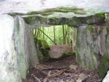

<< Our Photo Pages >> La Pierre Folle de Thiré - Burial Chamber or Dolmen in France in Pays de la Loire:Vendée (85)
Submitted by TheCaptain on Saturday, 16 April 2005 Page Views: 3882
Neolithic and Bronze AgeSite Name: La Pierre Folle de ThiréCountry: France
NOTE: This site is 6.531 km away from the location you searched for.
Département: Pays de la Loire:Vendée (85) Type: Burial Chamber or Dolmen
Nearest Town: Chantonnay Nearest Village: Thiré
Latitude: 46.552500N Longitude: 0.99806W
Condition:
| 5 | Perfect |
| 4 | Almost Perfect |
| 3 | Reasonable but with some damage |
| 2 | Ruined but still recognisable as an ancient site |
| 1 | Pretty much destroyed, possibly visible as crop marks |
| 0 | No data. |
| -1 | Completely destroyed |
| 5 | Superb |
| 4 | Good |
| 3 | Ordinary |
| 2 | Not Good |
| 1 | Awful |
| 0 | No data. |
| 5 | Can be driven to, probably with disabled access |
| 4 | Short walk on a footpath |
| 3 | Requiring a bit more of a walk |
| 2 | A long walk |
| 1 | In the middle of nowhere, a nightmare to find |
| 0 | No data. |
| 5 | co-ordinates taken by GPS or official recorded co-ordinates |
| 4 | co-ordinates scaled from a detailed map |
| 3 | co-ordinates scaled from a bad map |
| 2 | co-ordinates of the nearest village |
| 1 | co-ordinates of the nearest town |
| 0 | no data |
Internal Links:
External Links:
I have visited· I would like to visit
johnstone visited on 12th Sep 2013 - their rating: Cond: 2 Amb: 3 Access: 4
")
Base Mérimée (Historic Monument)
You may be viewing yesterday's version of this page. To see the most up to date information please register for a free account.
")
")
")
")
")
")
")
")
")
")
")
")
")
")
")
")
")
")
")
")
")
")
Do not use the above information on other web sites or publications without permission of the contributor.
Click here to see more info for this site
Nearby sites
Click here to view sites on an interactive map of the areaKey: Red: member's photo, Blue: 3rd party photo, Yellow: other image, Green: no photo - please go there and take one, Grey: site destroyed
Download sites to:
KML (Google Earth)
GPX (GPS waypoints)
CSV (Garmin/Navman)
CSV (Excel)
To unlock full downloads you need to sign up as a Contributory Member. Otherwise downloads are limited to 50 sites.
Turn off the page maps and other distractions
Nearby sites listing. In the following links * = Image available
12.8km NNE 22° Ciste des Cous* Burial Chamber or Dolmen
12.8km NNE 23° Pierre Folle des Cous* Burial Chamber or Dolmen
13.0km NNE 22° Menhir du Fief de Cous* Standing Stone (Menhir)
13.0km NNE 21° Dolmen de la Pierre Rousse* Burial Chamber or Dolmen
13.1km NNE 21° Menhir de la Pierre Rousse* Standing Stone (Menhir)
13.1km NNE 21° Dolmen de la Jaudonnière* Passage Grave
13.2km NNE 29° Menhir de la Vierge* Standing Stone (Menhir)
14.0km N 11° Dolmen des Landes* Burial Chamber or Dolmen
14.0km NNE 11° Menhir des Landes* Standing Stone (Menhir)
16.3km WSW 248° La Frise Dolmen* Burial Chamber or Dolmen
19.1km NE 53° Pierre à Cupules des Girardières Rock Art
20.4km NNW 346° Menhirs du Château-des-Roches-Baritaud* Standing Stones
21.6km NE 47° Dolmen de la Pierre-qui-Vire* Burial Chamber or Dolmen
21.9km NE 50° Polissoir ou pierre à sculpture Polissoir
23.2km W 263° Pierres Folles du Follet* Standing Stones
25.7km ESE 113° Dolmen de la Pierre Virante* Burial Chamber or Dolmen
26.2km ESE 115° Dolmen de la Pierre Levée (Nieul sur l'Autise)* Burial Chamber or Dolmen
28.6km NNE 26° Deux polissoirs Polissoir
28.9km NNE 26° Dolmen du Marchais* Burial Chamber or Dolmen
29.0km WSW 253° Dolmen des Games* Burial Chamber or Dolmen
29.0km NNE 26° Pouzauges Stones* Not Known (by us)
29.6km WSW 244° Menhir de la Pierre Couchée (St Benoist)* Standing Stone (Menhir)
30.2km ESE 120° Enceinte de Champ-Durand* Ancient Village or Settlement
30.4km WSW 251° Pierre Levée de Chenillée* Standing Stone (Menhir)
32.1km WSW 251° Petites Jaunières* Standing Stone (Menhir)
View more nearby sites and additional images


 We would like to know more about this location. Please feel free to add a brief description and any relevant information in your own language.
 Wir möchten mehr über diese Stätte erfahren. Bitte zögern Sie nicht, eine kurze Beschreibung und relevante Informationen in Deutsch hinzuzufügen.
 Nous aimerions en savoir encore un peu sur les lieux. S'il vous plaît n'hesitez pas à ajouter une courte description et tous les renseignements pertinents dans votre propre langue.
 Quisieramos informarnos un poco más de las lugares. No dude en añadir una breve descripción y otros datos relevantes en su propio idioma.