


<< Our Photo Pages >> Three Hills Barrows, Woodford - Barrow Cemetery in England in Northamptonshire
Submitted by JoAtherton on Wednesday, 16 December 2009 Page Views: 7907
Neolithic and Bronze AgeSite Name: Three Hills Barrows, WoodfordCountry: England
NOTE: This site is 7.151 km away from the location you searched for.
County: Northamptonshire Type: Barrow Cemetery
Nearest Village: Woodford
Map Ref: SP961760
Latitude: 52.373624N Longitude: 0.589805W
Condition:
| 5 | Perfect |
| 4 | Almost Perfect |
| 3 | Reasonable but with some damage |
| 2 | Ruined but still recognisable as an ancient site |
| 1 | Pretty much destroyed, possibly visible as crop marks |
| 0 | No data. |
| -1 | Completely destroyed |
| 5 | Superb |
| 4 | Good |
| 3 | Ordinary |
| 2 | Not Good |
| 1 | Awful |
| 0 | No data. |
| 5 | Can be driven to, probably with disabled access |
| 4 | Short walk on a footpath |
| 3 | Requiring a bit more of a walk |
| 2 | A long walk |
| 1 | In the middle of nowhere, a nightmare to find |
| 0 | No data. |
| 5 | co-ordinates taken by GPS or official recorded co-ordinates |
| 4 | co-ordinates scaled from a detailed map |
| 3 | co-ordinates scaled from a bad map |
| 2 | co-ordinates of the nearest village |
| 1 | co-ordinates of the nearest town |
| 0 | no data |
Internal Links:
External Links:
I have visited· I would like to visit
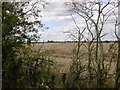
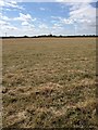
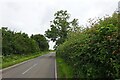
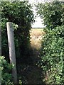
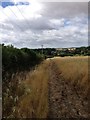
JoAtherton visited on 22nd Jun 2023 - their rating: Cond: 3 Amb: 4 Access: 4 Managed to park in a layby and walk about 10 mins down the main road to the footpath. Gradual climb over uneven ground to the summit of the hill where the Three Hills can be found. They have a wide margin around them protecting them from the plough - fabulous for butterflies and birds. Great views across the Northamptonshire countryside from the top of the mounds. They were covered in long grass during my visit so it was a challenge to see their actual shape but they don't appear to be perfect humps, with dense vegetation growing in places. Well worth the visit if you're passing but not as dramatic as others I have seen.
")
(RCHME 1975, 111-2 and plate 1).
Current condition: under grass, but extensively damaged by various activities
You may be viewing yesterday's version of this page. To see the most up to date information please register for a free account.
")
")
")
Do not use the above information on other web sites or publications without permission of the contributor.
Nearby Images from Geograph Britain and Ireland:
©2006(licence)
©2015(licence)
©2021(licence)
©2015(licence)
©2015(licence)
The above images may not be of the site on this page, they are loaded from Geograph.
Please Submit an Image of this site or go out and take one for us!
Click here to see more info for this site
Nearby sites
Key: Red: member's photo, Blue: 3rd party photo, Yellow: other image, Green: no photo - please go there and take one, Grey: site destroyed
Download sites to:
KML (Google Earth)
GPX (GPS waypoints)
CSV (Garmin/Navman)
CSV (Excel)
To unlock full downloads you need to sign up as a Contributory Member. Otherwise downloads are limited to 50 sites.
Turn off the page maps and other distractions
Nearby sites listing. In the following links * = Image available
3.5km S 178° Irthlingborough and Stanwick Barrows* Barrow Cemetery (SP963725)
3.8km SSE 158° West Cotton Monument Complex Long Barrow (SP97577248)
4.1km SSE 149° Cotton Henge* Henge (SP983725)
4.5km SSE 167° Raunds Ring Ditch Misc. Earthwork (SP972716)
4.5km S 174° Stanwick Lakes* Museum (SP96707150)
5.0km S 177° Redlands Farm Long Barrow Long Barrow (SP965710)
6.0km SW 229° Finedon Stone Marker Stone (SP9161871928)
6.7km ENE 56° Titchmarch Cursus Cursus (TL016798)
12.4km SE 135° Harrowick, Upper Dean Natural Stone / Erratic / Other Natural Feature (TL0507267416)
15.1km E 93° Seat of Judgement - Leighton Bromswold* Marker Stone (TL112756)
15.6km NNW 333° Parliament Stone* Natural Stone / Erratic / Other Natural Feature (SP888898)
16.2km SW 230° Mears Ashby Tumulus* Misc. Earthwork (SP839653)
16.8km SSW 213° Grendon Cursus Cursus (SP87256174)
17.7km SSE 167° Felmersham Cursus Cursus (TL004588)
19.0km NNW 342° The Jo Stone* Natural Stone / Erratic / Other Natural Feature (SP8995293949)
19.0km S 184° Harrold Barrows* Barrow Cemetery (SP95245702)
20.4km SE 144° Bolnhurst Earthwork Misc. Earthwork (TL084597)
20.5km NNW 328° Great Easton Roman Well* Holy Well or Sacred Spring (SP850933)
21.1km N 8° Blatherwycke stone cross Marker Stone (SP988969)
22.1km WSW 243° St John's Well (Boughton)* Holy Well or Sacred Spring (SP765656)
22.3km WSW 243° Shepherd's Race (Boughton) Turf Maze (SP764655)
22.5km WSW 250° Longmans Hill Long Barrow* Long Barrow (SP751677)
22.5km S 174° Holywell (Bedfordshire)* Holy Well or Sacred Spring (SP9907753646)
23.1km E 81° Monk's Hole Barrow Round Barrow(s) (TL1896479957)
23.6km WSW 246° Boughton bowl barrow* Round Barrow(s) (SP74706589)
View more nearby sites and additional images


 We would like to know more about this location. Please feel free to add a brief description and any relevant information in your own language.
 Wir möchten mehr über diese Stätte erfahren. Bitte zögern Sie nicht, eine kurze Beschreibung und relevante Informationen in Deutsch hinzuzufügen.
 Nous aimerions en savoir encore un peu sur les lieux. S'il vous plaît n'hesitez pas à ajouter une courte description et tous les renseignements pertinents dans votre propre langue.
 Quisieramos informarnos un poco más de las lugares. No dude en añadir una breve descripción y otros datos relevantes en su propio idioma.