 with our Megalithic Portal iPhone app")

<< Our Photo Pages >> Pierrelaye menhir - Standing Stone (Menhir) in France in Normandie:Calvados (14)
Submitted by TheCaptain on Sunday, 19 December 2004 Page Views: 3890
Neolithic and Bronze AgeSite Name: Pierrelaye menhir Alternative Name: Pierre LéeCountry: France
NOTE: This site is 6.731 km away from the location you searched for.
Département: Normandie:Calvados (14) Type: Standing Stone (Menhir)
Nearest Town: Caen Nearest Village: Villy-Bocage
Latitude: 49.103200N Longitude: 0.6575W
Condition:
| 5 | Perfect |
| 4 | Almost Perfect |
| 3 | Reasonable but with some damage |
| 2 | Ruined but still recognisable as an ancient site |
| 1 | Pretty much destroyed, possibly visible as crop marks |
| 0 | No data. |
| -1 | Completely destroyed |
| 5 | Superb |
| 4 | Good |
| 3 | Ordinary |
| 2 | Not Good |
| 1 | Awful |
| 0 | No data. |
| 5 | Can be driven to, probably with disabled access |
| 4 | Short walk on a footpath |
| 3 | Requiring a bit more of a walk |
| 2 | A long walk |
| 1 | In the middle of nowhere, a nightmare to find |
| 0 | No data. |
| 5 | co-ordinates taken by GPS or official recorded co-ordinates |
| 4 | co-ordinates scaled from a detailed map |
| 3 | co-ordinates scaled from a bad map |
| 2 | co-ordinates of the nearest village |
| 1 | co-ordinates of the nearest town |
| 0 | no data |
Internal Links:
External Links:
I have visited· I would like to visit
johnstone visited on 25th Jun 2009 - their rating: Cond: 3 Amb: 1 Access: 1
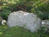
TheCaptain couldn't find on 21st Nov 2004 On a wet Sunday afternoon, following the disappointment of not getting to see the Pierre Dialan dolmen, my family encouraged me to go and find the nearby Menhir de Pierrelaye, which is marked on the IGN maps to the north of the village of Villers-Bocage.
My first attempt to get to see this 3 metre high stone was via the lane from the southeast, but upon reaching a farmyard there was no further way through. To much amusement getting out from here involved reversing all the way back up this lane to the road junction, a distance of about a mile ! Not to be beaten, I drove round the lanes to try and get a look from the northwest of where the stone is marked. The collection of farms and houses here is known as Pierrelaye, and indeed have signposts to Pierrelaye, but I could see no traces of a Menhir.
While turning round in a farmyard, an old farmer came out to see what was going on, so we asked in bad French where the stone was. After a while, he obviously realised what we were looking for and pointed up the hillside and said “Non monsieur, Fermée” while making arm gestures which made it clear I wasn’t going to see the stone. I assume it is on private land, and he wasn’t going to give me permission to go have a look. I have found information which tells that the stone is 3 metres high, with a base width of 2,5 metres, made of schist. It is situated in the middle of a field in a little valley.
")
Almost as wide as it is high, this stone is 3 metres tall, and 2.5 metres across at the base.
Base Mérimée (Historic Monument)
You may be viewing yesterday's version of this page. To see the most up to date information please register for a free account.
")
Do not use the above information on other web sites or publications without permission of the contributor.
Nearby Images from Flickr
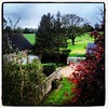
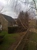
The above images may not be of the site on this page, but were taken nearby. They are loaded from Flickr so please click on them for image credits.
Click here to see more info for this site
Nearby sites
Click here to view sites on an interactive map of the areaKey: Red: member's photo, Blue: 3rd party photo, Yellow: other image, Green: no photo - please go there and take one, Grey: site destroyed
Download sites to:
KML (Google Earth)
GPX (GPS waypoints)
CSV (Garmin/Navman)
CSV (Excel)
To unlock full downloads you need to sign up as a Contributory Member. Otherwise downloads are limited to 50 sites.
Turn off the page maps and other distractions
Nearby sites listing. In the following links * = Image available
11.2km E 90° Nécropole mérovingienne à Évrecy* Ancient Village or Settlement
12.9km SSW 207° Pierre Dialan* Burial Chamber or Dolmen
15.4km NW 319° Domaine de Castillon* Ancient Village or Settlement
18.7km S 191° Pierre du Hu* Standing Stone (Menhir)
18.7km S 191° Montchauvet Alignements* Standing Stones
18.7km SSE 156° Menhir de la Belle Roche* Standing Stone (Menhir)
19.4km N 350° Musée Baron Gerard Museum
19.4km ENE 72° Menhir dit la Pierre Couchée (Louvigny)* Standing Stone (Menhir)
20.2km ENE 57° Rots necropolis Barrow Cemetery
20.5km SSE 167° Pierres Druidiques de Becquerel Rock Art
20.9km S 184° Menhir de la Pierre Grise (Lassy) Standing Stone (Menhir)
21.5km NE 47° Pierre Tourneresse, Cairon* Chambered Tomb
21.5km E 92° La Hogue* Chambered Tomb
22.0km ESE 103° Pierre Tournante (Fresnay-le-Puceux)* Standing Stone (Menhir)
22.1km ENE 76° Fleury-sur-Orne necropolis* Barrow Cemetery
22.1km E 92° La Hoguette* Chambered Tomb
22.7km NNE 27° Menhir des Planches* Standing Stone (Menhir)
23.3km ENE 67° Musée de Normandie* Museum
24.1km NE 44° Les Grosses Devises (W)* Standing Stones
24.1km NNE 27° Menhir des Demoiselles (Colombiers-sur-Seulles)* Standing Stone (Menhir)
24.2km NNE 30° Amblie necropole Barrow Cemetery
24.3km NE 45° Les Grosses Devises (E)* Standing Stone (Menhir)
24.6km NNE 29° Colombiers-sur-Seulles tumulus* Chambered Tomb
25.3km NE 38° Menhir de la Demoiselle de Bracqueville* Standing Stone (Menhir)
25.4km SE 140° Mégalithe du Pré-du-Vivret* Burial Chamber or Dolmen
View more nearby sites and additional images


 We would like to know more about this location. Please feel free to add a brief description and any relevant information in your own language.
 Wir möchten mehr über diese Stätte erfahren. Bitte zögern Sie nicht, eine kurze Beschreibung und relevante Informationen in Deutsch hinzuzufügen.
 Nous aimerions en savoir encore un peu sur les lieux. S'il vous plaît n'hesitez pas à ajouter une courte description et tous les renseignements pertinents dans votre propre langue.
 Quisieramos informarnos un poco más de las lugares. No dude en añadir una breve descripción y otros datos relevantes en su propio idioma.