 with our Megalithic Portal iPhone app")


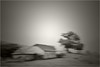
<< Our Photo Pages >> Courraüs de Houndas Cromlechs - Stone Circle in France in Aquitaine:Pyrénées-Atlantiques 64
Submitted by holger_rix on Sunday, 10 January 2016 Page Views: 1147
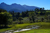
Neolithic and Bronze AgeSite Name: Courraüs de Houndas CromlechsCountry: France
NOTE: This site is 5.393 km away from the location you searched for.
Département: Aquitaine:Pyrénées-Atlantiques 64 Type: Stone Circle
Latitude: 43.061680N Longitude: 0.45805W
Condition:
| 5 | Perfect |
| 4 | Almost Perfect |
| 3 | Reasonable but with some damage |
| 2 | Ruined but still recognisable as an ancient site |
| 1 | Pretty much destroyed, possibly visible as crop marks |
| 0 | No data. |
| -1 | Completely destroyed |
| 5 | Superb |
| 4 | Good |
| 3 | Ordinary |
| 2 | Not Good |
| 1 | Awful |
| 0 | No data. |
| 5 | Can be driven to, probably with disabled access |
| 4 | Short walk on a footpath |
| 3 | Requiring a bit more of a walk |
| 2 | A long walk |
| 1 | In the middle of nowhere, a nightmare to find |
| 0 | No data. |
| 5 | co-ordinates taken by GPS or official recorded co-ordinates |
| 4 | co-ordinates scaled from a detailed map |
| 3 | co-ordinates scaled from a bad map |
| 2 | co-ordinates of the nearest village |
| 1 | co-ordinates of the nearest town |
| 0 | no data |
Be the first person to rate this site - see the 'Contribute!' box in the right hand menu.
Internal Links:
External Links:
")
You may be viewing yesterday's version of this page. To see the most up to date information please register for a free account.
")
")
Do not use the above information on other web sites or publications without permission of the contributor.
Nearby Images from Flickr
The above images may not be of the site on this page, but were taken nearby. They are loaded from Flickr so please click on them for image credits.
Click here to see more info for this site
Nearby sites
Click here to view sites on an interactive map of the areaKey: Red: member's photo, Blue: 3rd party photo, Yellow: other image, Green: no photo - please go there and take one, Grey: site destroyed
Download sites to:
KML (Google Earth)
GPX (GPS waypoints)
CSV (Garmin/Navman)
CSV (Excel)
To unlock full downloads you need to sign up as a Contributory Member. Otherwise downloads are limited to 50 sites.
Turn off the page maps and other distractions
Nearby sites listing. In the following links * = Image available
1.1km NE 55° Lou Couraus Cromlechs* Stone Circle
5.5km NNE 27° Musée Ethnologique et Archéologique d'Arudy* Museum
7.5km N 9° Calhau de Teberno Dolmen* Burial Chamber or Dolmen
9.4km SW 226° Grotte de Gandon-Lassus Cave or Rock Shelter
14.5km W 272° Lourdios Tumulus Chambered Cairn
15.9km NNW 337° Dolmen du Casse de Crampé Burial Chamber or Dolmen
16.8km NNW 334° Dolmen de Peyrecor* Burial Chamber or Dolmen
16.8km NNW 334° Tumulus de Peyrecor* Round Cairn
19.7km SE 125° Menhir de Soulor Standing Stone (Menhir)
20.1km SSW 207° Modern Stones (Borce)* Modern Stone Circle etc
20.4km NE 55° Oppidum d'Asson Hillfort
20.4km SSW 202° Col d'Arras Dolmen* Burial Chamber or Dolmen
20.9km S 177° Cromlech de Bious Oumettes* Stone Circle
21.1km S 178° Cromlech de la Cabane de Bious Oumettes Stone Circle
21.3km S 176° Col Long de Magnabaigt Chromlechs* Stone Circle
21.6km S 170° Cabane de Chérue Cromlechs* Stone Circle
21.6km S 187° Quartier d'Aas Cromlechs* Stone Circle
21.9km S 173° Cabane Magnabaigt Est Cromlech* Stone Circle
23.1km S 180° Plaa de Bious Cromlech* Stone Circle
23.2km S 174° Magnabaigt Cromlechs* Stone Circle
23.2km S 174° Magnabaigt Tumulus* Round Barrow(s)
23.4km S 183° Arougos Cromlechs* Stone Circle
23.6km S 187° Col d'Ayous Cromlech* Stone Circle
23.6km S 184° Roumassot Cromlechs* Stone Circle
23.8km S 186° Lac Gentau Cromlechs* Stone Circle
View more nearby sites and additional images


 We would like to know more about this location. Please feel free to add a brief description and any relevant information in your own language.
 Wir möchten mehr über diese Stätte erfahren. Bitte zögern Sie nicht, eine kurze Beschreibung und relevante Informationen in Deutsch hinzuzufügen.
 Nous aimerions en savoir encore un peu sur les lieux. S'il vous plaît n'hesitez pas à ajouter une courte description et tous les renseignements pertinents dans votre propre langue.
 Quisieramos informarnos un poco más de las lugares. No dude en añadir una breve descripción y otros datos relevantes en su propio idioma.