

<< Our Photo Pages >> Sechebec Dolmen - Burial Chamber or Dolmen in France in Poitou:Charente (16)
Submitted by TheCaptain on Saturday, 16 April 2005 Page Views: 4457
Neolithic and Bronze AgeSite Name: Sechebec Dolmen Alternative Name: Dolmen de SechebecCountry: France
NOTE: This site is 2.525 km away from the location you searched for.
Département: Poitou:Charente (16) Type: Burial Chamber or Dolmen
Nearest Town: Cognac Nearest Village: Cognac
Latitude: 45.692500N Longitude: 0.3098W
Condition:
| 5 | Perfect |
| 4 | Almost Perfect |
| 3 | Reasonable but with some damage |
| 2 | Ruined but still recognisable as an ancient site |
| 1 | Pretty much destroyed, possibly visible as crop marks |
| 0 | No data. |
| -1 | Completely destroyed |
| 5 | Superb |
| 4 | Good |
| 3 | Ordinary |
| 2 | Not Good |
| 1 | Awful |
| 0 | No data. |
| 5 | Can be driven to, probably with disabled access |
| 4 | Short walk on a footpath |
| 3 | Requiring a bit more of a walk |
| 2 | A long walk |
| 1 | In the middle of nowhere, a nightmare to find |
| 0 | No data. |
| 5 | co-ordinates taken by GPS or official recorded co-ordinates |
| 4 | co-ordinates scaled from a detailed map |
| 3 | co-ordinates scaled from a bad map |
| 2 | co-ordinates of the nearest village |
| 1 | co-ordinates of the nearest town |
| 0 | no data |
Internal Links:
External Links:
I have visited· I would like to visit
DrewParsons would like to visit
johnstone visited on 18th Jun 2014 - their rating: Cond: 3 Amb: 2 Access: 5
TheCaptain visited on 4th Jun 2005 - their rating: Cond: 3 Amb: 2 Access: 5 This dolmen comes with its own block of flats, "Residence du Dolmen", which is currently for sale, in the western outskirts of Cognac, not too far from the big sports centre.
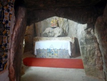
The 4.5 by 2.5 metre chamber is covered by a single large capstone, held up on 8 external support stones and with another stone on the inside, but it is not very high off the ground. It would not surprise me at all if this has been somewhat modified for safety reasons, as it is now part of a sort of play area surrounded by blocks of flats. But at least it is still here, and nice to look at.
Average ratings for this site from all visit loggers: Condition: 3 Ambience: 2 Access: 5
")
The 4.5 by 2.5 metre chamber is covered by a single large capstone, held up on 8 external support stones and with another stone on the inside, but it is not very high off the ground.
It would not surprise me at all if this has been somewhat modified for safety reasons, as it is now part of a sort of play area surrounded by blocks of flats. But at least it is still here, and nice to look at.
Base Mérimée (Historic Monument)
Base Mérimée (Patrimonial Inventory)
You may be viewing yesterday's version of this page. To see the most up to date information please register for a free account.
")
")
")
")
")
Do not use the above information on other web sites or publications without permission of the contributor.
Click here to see more info for this site
Nearby sites
Click here to view sites on an interactive map of the areaKey: Red: member's photo, Blue: 3rd party photo, Yellow: other image, Green: no photo - please go there and take one, Grey: site destroyed
Download sites to:
KML (Google Earth)
GPX (GPS waypoints)
CSV (Garmin/Navman)
CSV (Excel)
To unlock full downloads you need to sign up as a Contributory Member. Otherwise downloads are limited to 50 sites.
Turn off the page maps and other distractions
Nearby sites listing. In the following links * = Image available
2.4km SW 219° Pierre Levée (Châteaubernard)* Burial Chamber or Dolmen
4.5km E 94° Garde Epée Dolmen* Burial Chamber or Dolmen
4.6km E 95° Rocher de la Vache* Burial Chamber or Dolmen
9.1km NE 34° Sainte-Sévère tumulus Chambered Tomb
10.7km E 84° La Motte a Poljeau* Chambered Tomb
13.4km S 175° Saint Fort Dolmen* Burial Chamber or Dolmen
13.5km ESE 119° Courades Dolmen* Burial Chamber or Dolmen
15.8km ESE 122° La Pierre Levée (Bouteville) Burial Chamber or Dolmen
16.4km WNW 293° Paléosite* Museum
16.8km WNW 294° Abri de la Roche-a-Pierrot Cave or Rock Shelter
17.0km S 189° La Pierre Percée (Sainte Lheurine)* Sculptured Stone
17.4km S 187° Tumulus du Cruchaud* Long Barrow
17.7km NNW 335° Enceinte néolithique chemin Saint Jean Causewayed Enclosure
18.7km SSE 157° Dolmen dit Gros-Caillou Burial Chamber or Dolmen
19.4km SSW 210° Tumulus du Planti d'Audouin Round Barrow(s)
20.0km W 273° Terrier de la Fade Chambered Tomb
20.8km NE 53° Borne de la Pierre Qui Danse* Standing Stone (Menhir)
21.6km NNW 341° Pierre du Terrier de Babelot Polissoir
23.2km NW 323° La Roche tumulus Chambered Tomb
24.9km WNW 284° Musée de Préhistoire (Saintes)* Museum
26.1km WNW 284° Saintes Polissoir Polissoir
26.3km SW 218° Menhirs de Ménac Standing Stones
26.9km W 270° Dolmen de la Pierre Qui Saute* Burial Chamber or Dolmen
28.4km SSE 162° Dolmen du Gros-Caillou Burial Chamber or Dolmen
29.4km NW 319° Menhir des Richards* Standing Stone (Menhir)
View more nearby sites and additional images


 We would like to know more about this location. Please feel free to add a brief description and any relevant information in your own language.
 Wir möchten mehr über diese Stätte erfahren. Bitte zögern Sie nicht, eine kurze Beschreibung und relevante Informationen in Deutsch hinzuzufügen.
 Nous aimerions en savoir encore un peu sur les lieux. S'il vous plaît n'hesitez pas à ajouter une courte description et tous les renseignements pertinents dans votre propre langue.
 Quisieramos informarnos un poco más de las lugares. No dude en añadir una breve descripción y otros datos relevantes en su propio idioma.