


<< Our Photo Pages >> Spring Bottom - Holy Well or Sacred Spring in England in Surrey
Submitted by amunptah on Monday, 30 August 2010 Page Views: 3905
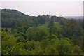
Springs and Holy WellsSite Name: Spring BottomCountry: England
NOTE: This site is 1.405 km away from the location you searched for.
County: Surrey Type: Holy Well or Sacred Spring
Nearest Town: Caterham Nearest Village: Chaldon
Map Ref: TQ321531
Latitude: 51.261762N Longitude: 0.10811W
Condition:
| 5 | Perfect |
| 4 | Almost Perfect |
| 3 | Reasonable but with some damage |
| 2 | Ruined but still recognisable as an ancient site |
| 1 | Pretty much destroyed, possibly visible as crop marks |
| 0 | No data. |
| -1 | Completely destroyed |
| 5 | Superb |
| 4 | Good |
| 3 | Ordinary |
| 2 | Not Good |
| 1 | Awful |
| 0 | No data. |
| 5 | Can be driven to, probably with disabled access |
| 4 | Short walk on a footpath |
| 3 | Requiring a bit more of a walk |
| 2 | A long walk |
| 1 | In the middle of nowhere, a nightmare to find |
| 0 | No data. |
| 5 | co-ordinates taken by GPS or official recorded co-ordinates |
| 4 | co-ordinates scaled from a detailed map |
| 3 | co-ordinates scaled from a bad map |
| 2 | co-ordinates of the nearest village |
| 1 | co-ordinates of the nearest town |
| 0 | no data |
Internal Links:
External Links:
I have visited· I would like to visit
Lana would like to visit
")
Water wells up from a spring, forming a small pool. Then the water flows through a small tunnel, down the hill into a larger pond. The water is very clear and beautiful.
You may be viewing yesterday's version of this page. To see the most up to date information please register for a free account.
")
Do not use the above information on other web sites or publications without permission of the contributor.
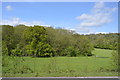
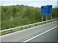
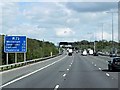
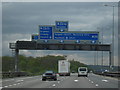
Nearby Images from Geograph Britain and Ireland:
©2015(licence)
©2013(licence)
©2013(licence)
©2009(licence)
©2008(licence)
The above images may not be of the site on this page, they are loaded from Geograph.
Please Submit an Image of this site or go out and take one for us!
Click here to see more info for this site
Nearby sites
Key: Red: member's photo, Blue: 3rd party photo, Yellow: other image, Green: no photo - please go there and take one, Grey: site destroyed
Download sites to:
KML (Google Earth)
GPX (GPS waypoints)
CSV (Garmin/Navman)
CSV (Excel)
To unlock full downloads you need to sign up as a Contributory Member. Otherwise downloads are limited to 50 sites.
Turn off the page maps and other distractions
Nearby sites listing. In the following links * = Image available
892m E 81° War Coppice Camp Hillfort (TQ32985326)
1.4km SE 146° North Park Farm* Ancient Village or Settlement (TQ329520)
2.9km NNW 336° St Peter and St Paul's Church (Chaldon)* Ancient Cross (TQ3087455694)
3.1km ESE 118° Godstone Tumulus* Artificial Mound (TQ349517)
3.9km ESE 115° St Mary's Well (Godstone)* Holy Well or Sacred Spring (TQ357515)
4.0km ESE 115° Walker Miles Memorial* Modern Stone Circle etc (TQ358515)
4.6km ESE 121° Diana's Well Holy Well or Sacred Spring (TQ361508)
4.6km ESE 120° Leigh Place Stone* Natural Stone / Erratic / Other Natural Feature (TQ362509)
5.0km W 267° Gatton Park, The Millennium Stones* Modern Stone Circle etc (TQ271527)
5.1km NNW 337° Farthing Downs* Barrow Cemetery (TQ300578)
5.4km E 85° St. Thomas's Well (Godstone) Holy Well or Sacred Spring (TQ375537)
5.6km WSW 239° Whitepost Hill Spring Holy Well or Sacred Spring (TQ273501)
5.7km NW 312° Chipstead Well Holy Well or Sacred Spring (TQ278568)
5.7km WSW 241° Waterslade Spring Holy Well or Sacred Spring (TQ272502)
5.8km SW 222° Royal Earlswood Stones* Modern Stone Circle etc (TQ283487)
5.8km SW 235° Redhill Common* Round Barrow(s) (TQ274496)
6.7km WNW 291° St. Margaret's Well (Mugswell)* Holy Well or Sacred Spring (TQ258553)
7.1km SW 232° Earlswood Common Barrow Cemetery Barrow Cemetery (TQ266486)
7.2km NE 56° Nore Hill Bronze Age Enclosure Misc. Earthwork (TQ380573)
7.5km N 3° Riddlesdown Newe Ditch* Misc. Earthwork (TQ3230460572)
8.8km WSW 254° Reigate Heath Barrows* Barrow Cemetery (TQ23725042)
10.2km N 11° Croham Hurst* Round Barrow(s) (TQ338632)
10.5km NW 318° Gally Hills Barrow Cemetery (TQ249607)
10.8km SE 145° St. Margaret's Well (Lingfield)* Holy Well or Sacred Spring (TQ386444)
12.1km NNW 341° Queen Anne's Well (Carshalton)* Holy Well or Sacred Spring (TQ279645)
View more nearby sites and additional images


 We would like to know more about this location. Please feel free to add a brief description and any relevant information in your own language.
 Wir möchten mehr über diese Stätte erfahren. Bitte zögern Sie nicht, eine kurze Beschreibung und relevante Informationen in Deutsch hinzuzufügen.
 Nous aimerions en savoir encore un peu sur les lieux. S'il vous plaît n'hesitez pas à ajouter une courte description et tous les renseignements pertinents dans votre propre langue.
 Quisieramos informarnos un poco más de las lugares. No dude en añadir una breve descripción y otros datos relevantes en su propio idioma.