


<< Text Pages >> Jedburgh Rock Art - Rock Art in Scotland in Scottish Borders
Submitted by SolarMegalith on Saturday, 10 November 2012 Page Views: 3257
Rock ArtSite Name: Jedburgh Rock ArtCountry: Scotland
NOTE: This site is 5.042 km away from the location you searched for.
County: Scottish Borders Type: Rock Art
Nearest Town: Jedburgh
Map Ref: NT651204
Latitude: 55.476166N Longitude: 2.55368W
Condition:
| 5 | Perfect |
| 4 | Almost Perfect |
| 3 | Reasonable but with some damage |
| 2 | Ruined but still recognisable as an ancient site |
| 1 | Pretty much destroyed, possibly visible as crop marks |
| 0 | No data. |
| -1 | Completely destroyed |
| 5 | Superb |
| 4 | Good |
| 3 | Ordinary |
| 2 | Not Good |
| 1 | Awful |
| 0 | No data. |
| 5 | Can be driven to, probably with disabled access |
| 4 | Short walk on a footpath |
| 3 | Requiring a bit more of a walk |
| 2 | A long walk |
| 1 | In the middle of nowhere, a nightmare to find |
| 0 | No data. |
| 5 | co-ordinates taken by GPS or official recorded co-ordinates |
| 4 | co-ordinates scaled from a detailed map |
| 3 | co-ordinates scaled from a bad map |
| 2 | co-ordinates of the nearest village |
| 1 | co-ordinates of the nearest town |
| 0 | no data |
Be the first person to rate this site - see the 'Contribute!' box in the right hand menu.
Internal Links:
External Links:
I have visited· I would like to visit
Anne T visited (still working on) on 23rd May 2015 Jedburgh Rock Art: We spotted this site page after our last visit to Jedburgh earlier this month, and having missed this piece of rock art first time round, we decided to stop when we next passed through to see if we could find it. Armed with SolarMegalith's grid reference, we went scouting, but were unable to find any rock or boulders in the vicinity.
I called up this page on my mobile phone and went into the visitor centre to ask if they knew anything about it. Neither of the guides knew anything about this at all, taking my phone to consult each other, and even double-checking the guide book to find out where the courtyard referred to in the earlier reference might be.
In the end, we all had to admit defeat on this occasion, but I'd be interested to find out if this piece of rock art has been moved to a local museum. Curious! I'd now love to found this stone and post a photograph.
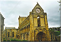
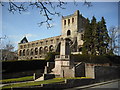
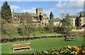
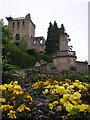
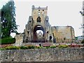
This cup-and-ring marked stone was discovered in Jedburgh Abbey in 1903, currently it is located in its courtyard.
Reference:
Morris, R.B.W. 1981. The Prehistoric Rock Art of Southern Scotland. Oxford: B.A.R. (p. 38-39).
You may be viewing yesterday's version of this page. To see the most up to date information please register for a free account.
Do not use the above information on other web sites or publications without permission of the contributor.
Nearby Images from Geograph Britain and Ireland:
©2006(licence)
©2009(licence)
©2014(licence)
©2009(licence)
©2014(licence)
The above images may not be of the site on this page, they are loaded from Geograph.
Please Submit an Image of this site or go out and take one for us!
Click here to see more info for this site
Nearby sites
Key: Red: member's photo, Blue: 3rd party photo, Yellow: other image, Green: no photo - please go there and take one, Grey: site destroyed
Download sites to:
KML (Google Earth)
GPX (GPS waypoints)
CSV (Garmin/Navman)
CSV (Excel)
To unlock full downloads you need to sign up as a Contributory Member. Otherwise downloads are limited to 50 sites.
Turn off the page maps and other distractions
Nearby sites listing. In the following links * = Image available
54m WSW 248° Jedburgh Ancient Christian Stones* Ancient Cross (NT65052038)
3.7km NNW 344° Harestanes (Ancrum) Stone Circle (NT641240)
3.8km NNW 343° Harestanes (Ancrum) Stone Circle (NT640240)
4.0km SSW 199° Gilliestongues Promontory Fort / Cliff Castle (NT63721659)
4.8km N 353° Woodside (Crailing) Standing Stone (Menhir) (NT64552517)
5.3km NNW 329° Castle Hill (Ancrum)* Hillfort (NT6239424909)
5.4km NNW 326° Ancrum Old Church* Sculptured Stone (NT6215024885)
5.6km NE 40° Crailing Cross* Ancient Cross (NT6879724676)
5.7km WSW 244° Bedrule Parish Church* Sculptured Stone (NT5992217925)
5.8km NNE 22° Nisbet 2 Sculptured Stone (NT67322572)
5.8km NNW 343° Harrietsfield Standing Stone (Menhir) (NT63442599)
6.0km WSW 248° Fast Castle (Bedrule)* Misc. Earthwork (NT59531822)
6.1km WSW 246° Bedrule Sculptured Stone (NT59501793)
8.2km N 11° Fairnington Stone Circle (NT667285)
8.4km SSE 160° Edgerston Hillfort (NT67981245)
8.5km SW 235° Rubers Law* Hillfort (NT58031557)
9.6km NE 47° Haughhead Kip (Eckford)* Sculptured Stone (NT72212683)
10.4km SE 129° Dark Wood* Cairn (NT73111377)
10.5km NNW 339° Maxton Burgh (St Boswells)* Ancient Cross (NT61333020)
10.7km ESE 109° Five Stanes A* Stone Circle (NT75261686)
10.8km ESE 114° Five Stanes B Stone Circle (NT7516)
10.9km ESE 113° Trestle Cairn* Stone Circle (NT75181612)
10.9km NNW 336° Hier Well (Benrig)* Holy Well or Sacred Spring (NT60703042)
11.1km NNW 336° St Boswell's Old Church* Ancient Cross (NT6063730533)
11.1km ESE 116° Dere Street Cairn* Round Cairn (NT75061552)
View more nearby sites and additional images


 We would like to know more about this location. Please feel free to add a brief description and any relevant information in your own language.
 Wir möchten mehr über diese Stätte erfahren. Bitte zögern Sie nicht, eine kurze Beschreibung und relevante Informationen in Deutsch hinzuzufügen.
 Nous aimerions en savoir encore un peu sur les lieux. S'il vous plaît n'hesitez pas à ajouter une courte description et tous les renseignements pertinents dans votre propre langue.
 Quisieramos informarnos un poco más de las lugares. No dude en añadir una breve descripción y otros datos relevantes en su propio idioma.