


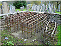
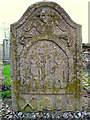
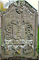
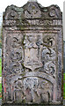
<< Text Pages >> Logierait 1 - Class II Pictish Symbol Stone in Scotland in Perth and Kinross
Submitted by alligator on Monday, 24 March 2003 Page Views: 8213
Early Medieval (Dark Age)Site Name: Logierait 1Country: Scotland
NOTE: This site is 0.291 km away from the location you searched for.
County: Perth and Kinross Type: Class II Pictish Symbol Stone
Map Ref: NN967520 Landranger Map Number: 52
Latitude: 56.648367N Longitude: 3.686271W
Condition:
| 5 | Perfect |
| 4 | Almost Perfect |
| 3 | Reasonable but with some damage |
| 2 | Ruined but still recognisable as an ancient site |
| 1 | Pretty much destroyed, possibly visible as crop marks |
| 0 | No data. |
| -1 | Completely destroyed |
| 5 | Superb |
| 4 | Good |
| 3 | Ordinary |
| 2 | Not Good |
| 1 | Awful |
| 0 | No data. |
| 5 | Can be driven to, probably with disabled access |
| 4 | Short walk on a footpath |
| 3 | Requiring a bit more of a walk |
| 2 | A long walk |
| 1 | In the middle of nowhere, a nightmare to find |
| 0 | No data. |
| 5 | co-ordinates taken by GPS or official recorded co-ordinates |
| 4 | co-ordinates scaled from a detailed map |
| 3 | co-ordinates scaled from a bad map |
| 2 | co-ordinates of the nearest village |
| 1 | co-ordinates of the nearest town |
| 0 | no data |
Be the first person to rate this site - see the 'Contribute!' box in the right hand menu.
Internal Links:
External Links:
Class II Pictish Symbol Stone in Perthshire
For details, visit: http://www.archaeoptics.co.uk/products/ecms/207.html
You may be viewing yesterday's version of this page. To see the most up to date information please register for a free account.
Do not use the above information on other web sites or publications without permission of the contributor.
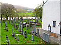
Nearby Images from Geograph Britain and Ireland:
©2006(licence)
©2006(licence)
©2006(licence)
©2006(licence)
©2006(licence)
The above images may not be of the site on this page, they are loaded from Geograph.
Please Submit an Image of this site or go out and take one for us!
Click here to see more info for this site
Nearby sites
Key: Red: member's photo, Blue: 3rd party photo, Yellow: other image, Green: no photo - please go there and take one, Grey: site destroyed
Download sites to:
KML (Google Earth)
GPX (GPS waypoints)
CSV (Garmin/Navman)
CSV (Excel)
To unlock full downloads you need to sign up as a Contributory Member. Otherwise downloads are limited to 50 sites.
Turn off the page maps and other distractions
Nearby sites listing. In the following links * = Image available
1.7km NNE 31° Tigh Na Ruaich* Stone Circle (NN97625346)
2.0km ESE 114° Clach Glas* Standing Stone (Menhir) (NN98535112)
2.1km W 272° Clach na Croiche* Stone Row / Alignment (NN94625211)
2.3km ESE 112° Haugh Cottages* Class III Pictish Cross Slab (NN988511)
2.5km ESE 119° Kilmorich Standing Stone (Menhir) (NN989507)
3.2km ESE 123° Kindallachan Standing Stones (NN993502)
3.2km ESE 123° Briughdearg Standing Stone (Menhir) (NN993502)
3.4km SE 126° Druid's Stone* Standing Stone (Menhir) (NN99384994)
4.1km WNW 288° Pitnacree* Standing Stone (Menhir) (NN92875337)
4.8km WNW 283° Haugh Of Grandtully Farm* Standing Stone (Menhir) (NN92035319)
5.0km NNW 334° Dunfallandy stone* Class II Pictish Symbol Stone (NN946565)
5.0km W 277° Balnabeggan* Rock Art (NN917527)
5.2km SE 139° Dowally* Standing Stones (NO0003948005)
5.4km NNW 337° Dunfallandy Cairn* Cairn (NN94745700)
5.5km NNE 23° Black Spout Wood Homestead Ancient Village or Settlement (NN990570)
5.6km NW 310° Clachan An Diridh* Stone Circle (NN92515574)
6.1km WNW 291° Clach Na Buidseach Rock Art (NN91085435)
6.7km NNW 336° Tobar Argan* Holy Well or Sacred Spring (NN941582)
7.1km NNW 338° Cnoc Dubh Stone Circle (NN94245871)
7.4km WNW 287° Findynate Farm* Standing Stones (NN89645430)
7.5km WNW 286° Pitcastle Standing Stones (NN895543)
7.7km NNW 343° Balnakeilly* Standing Stone (Menhir) (NN94655944)
7.8km NNW 340° Dane's Stone* Standing Stone (Menhir) (NN9425559414)
7.8km NNW 330° Faskally Cottages* Stone Circle (NN930589)
8.1km W 277° Tobairandonaich* Rock Art (NN88665320)
View more nearby sites and additional images


 We would like to know more about this location. Please feel free to add a brief description and any relevant information in your own language.
 Wir möchten mehr über diese Stätte erfahren. Bitte zögern Sie nicht, eine kurze Beschreibung und relevante Informationen in Deutsch hinzuzufügen.
 Nous aimerions en savoir encore un peu sur les lieux. S'il vous plaît n'hesitez pas à ajouter une courte description et tous les renseignements pertinents dans votre propre langue.
 Quisieramos informarnos un poco más de las lugares. No dude en añadir una breve descripción y otros datos relevantes en su propio idioma.