 with our Megalithic Portal iPhone app")


<< Text Pages >> Moredun Top - Hillfort in Scotland in Perth and Kinross
Submitted by Andy B on Friday, 12 September 2014 Page Views: 4779
Iron Age and Later PrehistorySite Name: Moredun TopCountry: Scotland
NOTE: This site is 1.745 km away from the location you searched for.
County: Perth and Kinross Type: Hillfort
Nearest Town: Perth
Map Ref: NO13621999
Latitude: 56.364309N Longitude: 3.399799W
Condition:
| 5 | Perfect |
| 4 | Almost Perfect |
| 3 | Reasonable but with some damage |
| 2 | Ruined but still recognisable as an ancient site |
| 1 | Pretty much destroyed, possibly visible as crop marks |
| 0 | No data. |
| -1 | Completely destroyed |
| 5 | Superb |
| 4 | Good |
| 3 | Ordinary |
| 2 | Not Good |
| 1 | Awful |
| 0 | No data. |
| 5 | Can be driven to, probably with disabled access |
| 4 | Short walk on a footpath |
| 3 | Requiring a bit more of a walk |
| 2 | A long walk |
| 1 | In the middle of nowhere, a nightmare to find |
| 0 | No data. |
| 5 | co-ordinates taken by GPS or official recorded co-ordinates |
| 4 | co-ordinates scaled from a detailed map |
| 3 | co-ordinates scaled from a bad map |
| 2 | co-ordinates of the nearest village |
| 1 | co-ordinates of the nearest town |
| 0 | no data |
Internal Links:
External Links:
Hillfort in Perth and Kinross
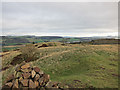
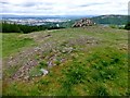
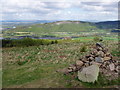
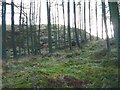
This important multi period fort crowns the summit of Moredun Top, the highest part of Moncrieffe Hill.
It consists of an enclosure formed within two ruined walls and measuring 560 feet by 330 feet. It has a dun-like structure measuring about 160 feet by 120 feet within a ruined wall originally about 12 feet thick which seems to overlie a sector of the inner wall of the larger enclosure. It is suggested that this is from the Pictish (late/post Roman] period.
More at Canmore.
You may be viewing yesterday's version of this page. To see the most up to date information please register for a free account.
Do not use the above information on other web sites or publications without permission of the contributor.
Nearby Images from Geograph Britain and Ireland:
©2011(licence)
©2014(licence)
©2007(licence)
©2009(licence)
©2016(licence)
The above images may not be of the site on this page, they are loaded from Geograph.
Please Submit an Image of this site or go out and take one for us!
Click here to see more info for this site
Nearby sites
Key: Red: member's photo, Blue: 3rd party photo, Yellow: other image, Green: no photo - please go there and take one, Grey: site destroyed
Download sites to:
KML (Google Earth)
GPX (GPS waypoints)
CSV (Garmin/Navman)
CSV (Excel)
To unlock full downloads you need to sign up as a Contributory Member. Otherwise downloads are limited to 50 sites.
Turn off the page maps and other distractions
Nearby sites listing. In the following links * = Image available
501m WSW 256° Moncreiffe Hill* Hillfort (NO13131988)
660m S 181° Moncrieffe* Stone Circle (NO13601933)
660m S 175° Gask House Class II Pictish Symbol Stone (NO13661933)
660m S 175° Boar Stone* Class III Pictish Cross Slab (NO13661933)
806m SSW 210° Moncrieffe Timber Circle (NO132193)
1.8km WNW 297° Craigclowan Standing Stone (Menhir) (NO12022083)
2.6km WNW 284° Hilton Of Moncrieffe* Standing Stone (Menhir) (NO11062067)
2.8km W 279° Kirkton Hill Stone Circle (NO109205)
3.2km NNW 328° South Inch, Perth Standing Stone (Menhir) (NO12002274)
3.9km W 278° Callarfountain* Standing Stone (Menhir) (NO09752058)
4.2km NNW 335° Perth Museum and Art Gallery* Museum (NO119238)
4.2km NNW 335° Inchyra* Class I Pictish Symbol Stone (NO119238)
4.3km NNW 347° Murray Royal Hospital* Standing Stone (Menhir) (NO127242)
6.1km E 79° St Madoes Stones* Stone Row / Alignment (NO197210)
6.2km ESE 120° Abernethy Circle Stone Circle (NO189168)
6.2km NE 37° Commonbank* Stone Circle (NO1748824837)
6.2km NE 37° Commonbank* Stone Row / Alignment (NO17502484)
6.2km NE 40° Commonbank SE Stone Circle (NO177247)
6.5km ESE 123° Abernethy Symbol Stone* Class I Pictish Symbol Stone (NO18991638)
6.5km SE 126° Abernethy Den* Stone Circle (NO188161)
6.5km NNE 13° Murrayshall* Standing Stone (Menhir) (NO1519926265)
6.5km N 356° Sandy Road East Stone Circle (NO13282646)
6.5km N 356° Sandy Road* Stone Circle (NO1327526463)
6.8km NNE 29° Arnbathie Fort* Hillfort (NO1703125894)
7.3km NW 317° Hunting Tower Cursus (NO087254)
View more nearby sites and additional images

")
 We would like to know more about this location. Please feel free to add a brief description and any relevant information in your own language.
 Wir möchten mehr über diese Stätte erfahren. Bitte zögern Sie nicht, eine kurze Beschreibung und relevante Informationen in Deutsch hinzuzufügen.
 Nous aimerions en savoir encore un peu sur les lieux. S'il vous plaît n'hesitez pas à ajouter une courte description et tous les renseignements pertinents dans votre propre langue.
 Quisieramos informarnos un poco más de las lugares. No dude en añadir una breve descripción y otros datos relevantes en su propio idioma.