


<< Our Photo Pages >> Carse Farm 2 - Stone Circle in Scotland in Perth and Kinross
Submitted by Nick on Tuesday, 12 November 2002 Page Views: 8599
Neolithic and Bronze AgeSite Name: Carse Farm 2 Alternative Name: Carse Farm South; TegarmuchdCountry: Scotland
NOTE: This site is 0.806 km away from the location you searched for.
County: Perth and Kinross Type: Stone Circle
Map Ref: NN80284846 Landranger Map Number: 52
Latitude: 56.612669N Longitude: 3.952249W
Condition:
| 5 | Perfect |
| 4 | Almost Perfect |
| 3 | Reasonable but with some damage |
| 2 | Ruined but still recognisable as an ancient site |
| 1 | Pretty much destroyed, possibly visible as crop marks |
| 0 | No data. |
| -1 | Completely destroyed |
| 5 | Superb |
| 4 | Good |
| 3 | Ordinary |
| 2 | Not Good |
| 1 | Awful |
| 0 | No data. |
| 5 | Can be driven to, probably with disabled access |
| 4 | Short walk on a footpath |
| 3 | Requiring a bit more of a walk |
| 2 | A long walk |
| 1 | In the middle of nowhere, a nightmare to find |
| 0 | No data. |
| 5 | co-ordinates taken by GPS or official recorded co-ordinates |
| 4 | co-ordinates scaled from a detailed map |
| 3 | co-ordinates scaled from a bad map |
| 2 | co-ordinates of the nearest village |
| 1 | co-ordinates of the nearest town |
| 0 | no data |
Internal Links:
External Links:
I have visited· I would like to visit
SolarMegalith would like to visit
Uralsdaughter visited on 21st Aug 2018 - their rating: Cond: 3 Amb: 4 Access: 4
")
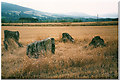
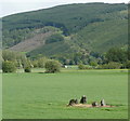
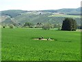
Just to the south of Dull (Carse Farm 1) the OS Map confidently announces another circle (remains of) at NN 806487. Don't be fooled, there is only one stone here As the field was full of cows, we didn't bother getting any closer to it either...
Update May 2017: For further information see Canmore ID 25629, which says: (by H A W Burl 1971) "There is insufficient ground evidence to classify this as a "four-poster". The single upright stone (A) survives in a ploughed field and is 1.8m high x 1.0m x 0.7m. The two recumbent stones (B and C) are slabs, half-buried in the soil 9.0m and 18.0m SW of the upright stone, and as planned by Cash. They are respectively 2.5m x 1.2m, with four cup marks near the centre on the upper horizontal surface, and 3.4m x 1.8m with two cup marks near the NW tip. No other stones survive." An additional entry from 1978 says that "Mrs. Stewart states that this is definitely a large stone circle and not a four poster." In 2011, this site was put under a watching brief.
The Northern Antiquarian (TNA) also features a page on this site - see their entry for Carse Farm (south), Dull, Perthshire, which includes photographs, an old drawing, Aubrey Burl's ground plan, directions to find the stone and a brief archaeology and history.
You may be viewing yesterday's version of this page. To see the most up to date information please register for a free account.
")
")
")
")
Do not use the above information on other web sites or publications without permission of the contributor.
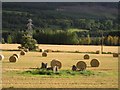
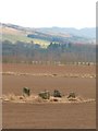
Nearby Images from Geograph Britain and Ireland:
©2007(licence)
©2009(licence)
©2008(licence)
©2011(licence)
©2012(licence)
The above images may not be of the site on this page, they are loaded from Geograph.
Please Submit an Image of this site or go out and take one for us!
Click here to see more info for this site
Nearby sites
Key: Red: member's photo, Blue: 3rd party photo, Yellow: other image, Green: no photo - please go there and take one, Grey: site destroyed
Download sites to:
KML (Google Earth)
GPX (GPS waypoints)
CSV (Garmin/Navman)
CSV (Excel)
To unlock full downloads you need to sign up as a Contributory Member. Otherwise downloads are limited to 50 sites.
Turn off the page maps and other distractions
Nearby sites listing. In the following links * = Image available
276m NNW 346° Carse Farm I* Stone Circle (NN80224873)
482m W 261° Tirinie Farm Barrow Round Barrow(s) (NN798484)
581m W 262° Tirinie Farm Circle Stone Circle (NN797484)
640m N 0° Appin of Dull* Rock Art (NN803491)
748m NE 42° Dull Cairn* Cairn (NN808490)
780m SSW 192° Taymouth (2) Standing Stones (NN801477)
797m NNE 31° Dull Cross (Aberfeldy) Ancient Cross (NN8070649135)
1.2km NE 54° Nether Tullicro* Standing Stone (Menhir) (NN81294916)
1.3km SSW 202° Croft Moraig* Stone Circle (NN79774727)
1.3km SSW 202° Croft Moraig Carving 1 Rock Art (NN7974647251)
1.4km SSE 161° St Adamnan's Well* Holy Well or Sacred Spring (NN807471)
2.0km SSW 207° Taymouth (1)* Standing Stones (NN793467)
2.1km SW 231° An Tobar* Holy Well or Sacred Spring (NN786472)
2.2km ENE 67° Balhomais* Stone Circle (NN82384926)
2.3km SW 222° Comrie Bridge Stone Circle (NN787468)
2.5km NE 37° Lurgan* Rock Art (NN8185550425)
2.9km ENE 70° Weem Cursus Cursus (NN83044939)
3.6km SSE 161° Craig Hill* Rock Art (NN81334506)
3.6km SSW 198° Tombuie Cottage* Rock Art (NN791451)
4.1km ENE 68° Weem Woods (Dull)* Rock Art (NN841499)
4.3km ENE 67° St David's Well (Perth and Kinross)* Holy Well or Sacred Spring (NN84274999)
4.5km SW 220° Spar Island* Crannog (NN773451)
4.5km ESE 103° An Torr* Rock Art (NN84694729)
4.6km ESE 112° Coilleachur Stone Circle (NN845466)
4.8km SW 221° Scottish Crannog Centre* Museum (NN7704444910)
View more nearby sites and additional images


 We would like to know more about this location. Please feel free to add a brief description and any relevant information in your own language.
 Wir möchten mehr über diese Stätte erfahren. Bitte zögern Sie nicht, eine kurze Beschreibung und relevante Informationen in Deutsch hinzuzufügen.
 Nous aimerions en savoir encore un peu sur les lieux. S'il vous plaît n'hesitez pas à ajouter une courte description et tous les renseignements pertinents dans votre propre langue.
 Quisieramos informarnos un poco más de las lugares. No dude en añadir una breve descripción y otros datos relevantes en su propio idioma.