


<< Text Pages >> Holy Well (Basford) - Holy Well or Sacred Spring in England in Nottinghamshire
Submitted by HOLYWELL on Friday, 04 February 2011 Page Views: 4135
Springs and Holy WellsSite Name: Holy Well (Basford)Country: England
NOTE: This site is 1.487 km away from the location you searched for.
County: Nottinghamshire Type: Holy Well or Sacred Spring
Nearest Town: Nottingham Nearest Village: Basford
Map Ref: SK553427
Latitude: 52.978803N Longitude: 1.177852W
Condition:
| 5 | Perfect |
| 4 | Almost Perfect |
| 3 | Reasonable but with some damage |
| 2 | Ruined but still recognisable as an ancient site |
| 1 | Pretty much destroyed, possibly visible as crop marks |
| 0 | No data. |
| -1 | Completely destroyed |
| 5 | Superb |
| 4 | Good |
| 3 | Ordinary |
| 2 | Not Good |
| 1 | Awful |
| 0 | No data. |
| 5 | Can be driven to, probably with disabled access |
| 4 | Short walk on a footpath |
| 3 | Requiring a bit more of a walk |
| 2 | A long walk |
| 1 | In the middle of nowhere, a nightmare to find |
| 0 | No data. |
| 5 | co-ordinates taken by GPS or official recorded co-ordinates |
| 4 | co-ordinates scaled from a detailed map |
| 3 | co-ordinates scaled from a bad map |
| 2 | co-ordinates of the nearest village |
| 1 | co-ordinates of the nearest town |
| 0 | no data |
Internal Links:
External Links:
Holy Well or Sacred Spring in Nottinghamshire
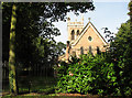
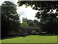
Now surrounded by urban sprawl St. Leodegariuss church is a quiet oasis in this busy area. Sadly, the holy well in its grounds and probably why the church was built is now lost. First recorded in 1409 it was apparently lost some time in the 1800s, when a twelve foot hole beside the porch was filled in with rubble and the site used to house the boiler. However, this was constantly being filled up with a depth of three foot of water, which had to be removed regularly by pumping. The hole it was then realised was the holy well, Morrell (1988) in his work on Nottinghamshire holy wells states that it arose again due to heavy rains in 1987.
You may be viewing yesterday's version of this page. To see the most up to date information please register for a free account.
Do not use the above information on other web sites or publications without permission of the contributor.
Nearby Images from Geograph Britain and Ireland:
©2023(licence)
©2010(licence)
©2023(licence)
©2021(licence)
©2010(licence)
The above images may not be of the site on this page, they are loaded from Geograph.
Please Submit an Image of this site or go out and take one for us!
Click here to see more info for this site
Nearby sites
Key: Red: member's photo, Blue: 3rd party photo, Yellow: other image, Green: no photo - please go there and take one, Grey: site destroyed
Download sites to:
KML (Google Earth)
GPX (GPS waypoints)
CSV (Garmin/Navman)
CSV (Excel)
To unlock full downloads you need to sign up as a Contributory Member. Otherwise downloads are limited to 50 sites.
Turn off the page maps and other distractions
Nearby sites listing. In the following links * = Image available
3.6km SSE 163° Rock Chapel of St Mary* Cave or Rock Shelter (SK56433926)
3.7km SSE 155° Nottingham Castle Museum Museum (SK569394)
3.7km ESE 103° St Ann's Well (Nottingham) Holy Well or Sacred Spring (SK58914191)
3.8km N 350° Bull's Well Holy Well or Sacred Spring (SK546464)
4.7km WSW 257° Catstone Hill* Natural Stone / Erratic / Other Natural Feature (SK50754156)
6.1km WNW 299° Holy Well (Watnall)* Holy Well or Sacred Spring (SK499456)
6.7km SW 234° The Hemlock Stone* Rock Outcrop (SK4995538661)
6.7km SW 227° Crow Hill Standing Stone* Standing Stone (Menhir) (SK50403805)
6.8km S 182° Clifton Pile Settlements* Ancient Village or Settlement (SK5513735946)
6.9km WSW 239° Healing Spring* Holy Well or Sacred Spring (SK494390)
7.2km NE 37° Cockpit Hill Hillfort (SK59584850)
8.0km ENE 72° The Lambley Spring* Holy Well or Sacred Spring (SK629452)
8.1km SW 229° Bob's Rock* Rock Outcrop (SK4927937319)
8.3km ENE 77° Burton Lodge Fort Hillfort (SK63364461)
8.4km SW 230° Stapleford Cross* Ancient Cross (SK489373)
8.5km NW 320° Robin Hood's Well (Beauvale)* Holy Well or Sacred Spring (SK49684915)
8.6km NNW 345° Linby Cross and Well* Ancient Cross (SK5351)
8.7km SSW 192° Cliffton Woods Well* Holy Well or Sacred Spring (SK5361134124)
8.8km NE 46° King's Well (Calverton) Holy Well or Sacred Spring (SK615489)
10.0km SSW 205° Conies Farm Stone Circle* Stone Circle (SK5115033599)
11.0km N 355° St Mary's Well (Newstead)* Holy Well or Sacred Spring (SK542537)
12.2km WSW 251° Hermit's Well (Dale Abbey) Holy Well or Sacred Spring (SK43783861)
13.1km WSW 250° Dale Hermitage* Cave or Rock Shelter (SK4338)
13.1km ESE 116° Stragglethorpe Bronze Age ring ditch* Round Barrow(s) (SK6720037057)
13.3km NE 39° Oldox Camp* Hillfort (SK635532)
View more nearby sites and additional images


 We would like to know more about this location. Please feel free to add a brief description and any relevant information in your own language.
 Wir möchten mehr über diese Stätte erfahren. Bitte zögern Sie nicht, eine kurze Beschreibung und relevante Informationen in Deutsch hinzuzufügen.
 Nous aimerions en savoir encore un peu sur les lieux. S'il vous plaît n'hesitez pas à ajouter une courte description et tous les renseignements pertinents dans votre propre langue.
 Quisieramos informarnos un poco más de las lugares. No dude en añadir una breve descripción y otros datos relevantes en su propio idioma.