


<< Our Photo Pages >> Friar Tuck's Well - Holy Well or Sacred Spring in England in Nottinghamshire
Submitted by HOLYWELL on Thursday, 06 January 2011 Page Views: 10031
Springs and Holy WellsSite Name: Friar Tuck's Well Alternative Name: St Lawrene's springCountry: England County: Nottinghamshire Type: Holy Well or Sacred Spring
Nearest Town: Mansfield Nearest Village: Blidworth
Map Ref: SK568569
Latitude: 53.106277N Longitude: 1.153018W
Condition:
| 5 | Perfect |
| 4 | Almost Perfect |
| 3 | Reasonable but with some damage |
| 2 | Ruined but still recognisable as an ancient site |
| 1 | Pretty much destroyed, possibly visible as crop marks |
| 0 | No data. |
| -1 | Completely destroyed |
| 5 | Superb |
| 4 | Good |
| 3 | Ordinary |
| 2 | Not Good |
| 1 | Awful |
| 0 | No data. |
| 5 | Can be driven to, probably with disabled access |
| 4 | Short walk on a footpath |
| 3 | Requiring a bit more of a walk |
| 2 | A long walk |
| 1 | In the middle of nowhere, a nightmare to find |
| 0 | No data. |
| 5 | co-ordinates taken by GPS or official recorded co-ordinates |
| 4 | co-ordinates scaled from a detailed map |
| 3 | co-ordinates scaled from a bad map |
| 2 | co-ordinates of the nearest village |
| 1 | co-ordinates of the nearest town |
| 0 | no data |
Internal Links:
External Links:
")
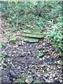
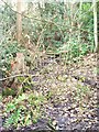
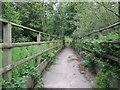
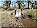
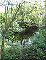
There is a considerable amount of mixed up folklore in this site, and Parish (2009) in his work on Nottinghamshire holy wells suggests that it may be that the well had pagan traditions. Indeed the legend that Tuck cursed the springs in this area, making them dry for seven year intervals and is very suggestive considering the number. It is shame that such a noted site is rather ruined and largely made inaccessible. It would be a good project for restoration, because even though the ornate railings and low walling have gone, the cascade remains and a spring does it still arise here leaving chalybeate water. However, there does not appear to be any old photo or illustration to suggest what it looks like. The water was used by local people for it was said to be healing, suggesting that another association, that of St. Lawrence conveyed these traditions and that this was a bone fide holy well. Friar Tuck lived in a nearby hermitage, local legend suggests that the remains of the moat can be found just before the spring head was where Friar Tuck resided. All in all a confused but interesting site.
You may be viewing yesterday's version of this page. To see the most up to date information please register for a free account.
")
")
")
Do not use the above information on other web sites or publications without permission of the contributor.
Nearby Images from Geograph Britain and Ireland:
©2011(licence)
©2011(licence)
©2019(licence)
©2024(licence)
©2013(licence)
The above images may not be of the site on this page, they are loaded from Geograph.
Please Submit an Image of this site or go out and take one for us!
Click here to see more info for this site
Nearby sites
Key: Red: member's photo, Blue: 3rd party photo, Yellow: other image, Green: no photo - please go there and take one, Grey: site destroyed
Download sites to:
KML (Google Earth)
GPX (GPS waypoints)
CSV (Garmin/Navman)
CSV (Excel)
To unlock full downloads you need to sign up as a Contributory Member. Otherwise downloads are limited to 50 sites.
Turn off the page maps and other distractions
Nearby sites listing. In the following links * = Image available
1.3km SE 136° The Druid Stone (Blidworth)* Natural Stone / Erratic / Other Natural Feature (SK577560)
2.1km ESE 122° Ashwell (Blidworth) Holy Well or Sacred Spring (SK586558)
4.1km SW 220° St Mary's Well (Newstead)* Holy Well or Sacred Spring (SK542537)
5.1km NNW 338° The Lady Well (Mansfield) Holy Well or Sacred Spring (SK548616)
6.6km ESE 106° Combs Camp Hillfort (SK63145512)
7.0km SSW 213° Linby Cross and Well* Ancient Cross (SK5351)
7.6km ESE 120° Oldox Camp* Hillfort (SK635532)
7.7km ESE 109° Hart's Well* Holy Well or Sacred Spring (SK6415254451)
8.8km SSE 162° Cockpit Hill Hillfort (SK59584850)
9.3km SSE 150° King's Well (Calverton) Holy Well or Sacred Spring (SK615489)
9.5km NNW 344° Sookholme Bath* Holy Well or Sacred Spring (SK5466)
10.5km SW 223° Robin Hood's Well (Beauvale)* Holy Well or Sacred Spring (SK49684915)
10.7km SSW 192° Bull's Well Holy Well or Sacred Spring (SK546464)
11.9km NNE 16° Thynghowe* Artificial Mound (SK59936834)
12.3km ESE 108° St Catherine's Well (Westthorpe)* Holy Well or Sacred Spring (SK68565327)
12.5km W 277° Blackwell Cross* Ancient Cross (SK443583)
13.2km SSE 153° The Lambley Spring* Holy Well or Sacred Spring (SK629452)
13.2km SSW 212° Holy Well (Watnall)* Holy Well or Sacred Spring (SK499456)
13.2km NNW 332° Scarcliffe Shelter 3 Cave or Rock Shelter (SK504685)
13.2km NNW 332° Scarcliffe Shelter 2 Cave or Rock Shelter (SK504685)
13.3km NNW 334° Scarcliffe Shelter 4 Cave or Rock Shelter (SK509688)
13.3km NNW 331° Scarcliffe Shelter 1 Cave or Rock Shelter (SK501684)
13.5km NNW 339° Langwith Cave* Cave or Rock Shelter (SK518695)
13.7km ESE 104° Southwell Minster* Early Christian Sculptured Stone (SK70165378)
13.9km SSE 153° Burton Lodge Fort Hillfort (SK63364461)
View more nearby sites and additional images


 We would like to know more about this location. Please feel free to add a brief description and any relevant information in your own language.
 Wir möchten mehr über diese Stätte erfahren. Bitte zögern Sie nicht, eine kurze Beschreibung und relevante Informationen in Deutsch hinzuzufügen.
 Nous aimerions en savoir encore un peu sur les lieux. S'il vous plaît n'hesitez pas à ajouter une courte description et tous les renseignements pertinents dans votre propre langue.
 Quisieramos informarnos un poco más de las lugares. No dude en añadir una breve descripción y otros datos relevantes en su propio idioma.