


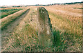
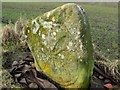
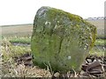
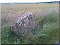
<< Our Photo Pages >> Skeith Stone - Class II Pictish Symbol Stone in Scotland in Fife
Submitted by hamish on Monday, 23 May 2005 Page Views: 14364
Early Medieval (Dark Age)Site Name: Skeith StoneCountry: Scotland County: Fife Type: Class II Pictish Symbol Stone
Nearest Town: Anstruther Nearest Village: Kilrenny
Map Ref: NO571046
Latitude: 56.232002N Longitude: 2.693582W
Condition:
| 5 | Perfect |
| 4 | Almost Perfect |
| 3 | Reasonable but with some damage |
| 2 | Ruined but still recognisable as an ancient site |
| 1 | Pretty much destroyed, possibly visible as crop marks |
| 0 | No data. |
| -1 | Completely destroyed |
| 5 | Superb |
| 4 | Good |
| 3 | Ordinary |
| 2 | Not Good |
| 1 | Awful |
| 0 | No data. |
| 5 | Can be driven to, probably with disabled access |
| 4 | Short walk on a footpath |
| 3 | Requiring a bit more of a walk |
| 2 | A long walk |
| 1 | In the middle of nowhere, a nightmare to find |
| 0 | No data. |
| 5 | co-ordinates taken by GPS or official recorded co-ordinates |
| 4 | co-ordinates scaled from a detailed map |
| 3 | co-ordinates scaled from a bad map |
| 2 | co-ordinates of the nearest village |
| 1 | co-ordinates of the nearest town |
| 0 | no data |
Internal Links:
External Links:
I have visited· I would like to visit
hamish has visited here
")
The stone has striations on one side and a carved wheel on the other.
You may be viewing yesterday's version of this page. To see the most up to date information please register for a free account.
")
")
")
Do not use the above information on other web sites or publications without permission of the contributor.
Nearby Images from Geograph Britain and Ireland:
©2008(licence)
©2010(licence)
©2010(licence)
©2017(licence)
©2007(licence)
The above images may not be of the site on this page, they are loaded from Geograph.
Please Submit an Image of this site or go out and take one for us!
Click here to see more info for this site
Nearby sites
Key: Red: member's photo, Blue: 3rd party photo, Yellow: other image, Green: no photo - please go there and take one, Grey: site destroyed
Download sites to:
KML (Google Earth)
GPX (GPS waypoints)
CSV (Garmin/Navman)
CSV (Excel)
To unlock full downloads you need to sign up as a Contributory Member. Otherwise downloads are limited to 50 sites.
Turn off the page maps and other distractions
Nearby sites listing. In the following links * = Image available
2.5km N 2° West Pitcorthie* Standing Stone (Menhir) (NO572071)
3.0km SW 224° St Fillan's Well (Pittenweem)* Holy Well or Sacred Spring (NO550025)
3.0km ENE 66° Caiplie* Class I Pictish Symbol Stone (NO599058)
5.1km NE 50° Sauchope* Class III Pictish Cross Slab (NO61040788)
5.4km NE 52° Devil's Blue Stane* Standing Stone (Menhir) (NO614079)
5.6km NE 55° Briery Well* Holy Well or Sacred Spring (NO617078)
6.9km NNW 333° Druid's Well (Dunino)* Holy Well or Sacred Spring (NO540108)
7.0km NNW 333° Dunino Den* Stone Row / Alignment (NO540109)
7.4km W 264° Easter Pitcorthie* Standing Stone (Menhir) (NO497039)
7.6km NNW 327° Dunino Stone Circle (NO530110)
7.6km WSW 241° Ardross souterrain* Souterrain (Fogou, Earth House) (NO5037500950)
8.9km NNW 348° Boarhills* Standing Stone (Menhir) (NO5525413356)
13.3km NNW 334° Monk's Well, St Andrews* Holy Well or Sacred Spring (NO514166)
13.4km NNW 328° St. Andrews Museum* Museum (NO5016)
13.7km NNW 331° The Blue Stane (St Andrews)* Standing Stone (Menhir) (NO5055216707)
14.1km NW 307° Drumcarrow Craig* Broch or Nuraghe (NO459132)
14.8km W 265° Largo Pictish Stone* Class II Pictish Symbol Stone (NO42340347)
16.4km W 279° Norrie's Law* Round Barrow(s) (NO409073)
16.7km W 263° Lundin Links* Stone Circle (NO40480272)
18.4km WNW 291° Spout Well* Holy Well or Sacred Spring (NO400114)
19.4km W 266° Aithernie (Scoonie) Cairn (NO37690339)
19.5km S 184° St. Andrew's Well Holy Well or Sacred Spring (NT55438520)
19.6km W 264° Balgrummo* Standing Stone (Menhir) (NO375029)
19.9km SSW 200° Eldbotle Wood (Dirleton) Cairn (NT50258593)
20.2km S 174° St. Baldred's Well (Auldhame)* Holy Well or Sacred Spring (NT59168450)
View more nearby sites and additional images


 We would like to know more about this location. Please feel free to add a brief description and any relevant information in your own language.
 Wir möchten mehr über diese Stätte erfahren. Bitte zögern Sie nicht, eine kurze Beschreibung und relevante Informationen in Deutsch hinzuzufügen.
 Nous aimerions en savoir encore un peu sur les lieux. S'il vous plaît n'hesitez pas à ajouter une courte description et tous les renseignements pertinents dans votre propre langue.
 Quisieramos informarnos un poco más de las lugares. No dude en añadir una breve descripción y otros datos relevantes en su propio idioma.