

<< Our Photo Pages >> Samson's Ribs - Promontory Fort / Cliff Castle in Scotland in Midlothian
Submitted by SolarMegalith on Tuesday, 28 March 2017 Page Views: 2735
Iron Age and Later PrehistorySite Name: Samson's RibsCountry: Scotland County: Midlothian Type: Promontory Fort / Cliff Castle
Nearest Town: Edinburgh
Map Ref: NT27457250
Latitude: 55.940052N Longitude: 3.163034W
Condition:
| 5 | Perfect |
| 4 | Almost Perfect |
| 3 | Reasonable but with some damage |
| 2 | Ruined but still recognisable as an ancient site |
| 1 | Pretty much destroyed, possibly visible as crop marks |
| 0 | No data. |
| -1 | Completely destroyed |
| 5 | Superb |
| 4 | Good |
| 3 | Ordinary |
| 2 | Not Good |
| 1 | Awful |
| 0 | No data. |
| 5 | Can be driven to, probably with disabled access |
| 4 | Short walk on a footpath |
| 3 | Requiring a bit more of a walk |
| 2 | A long walk |
| 1 | In the middle of nowhere, a nightmare to find |
| 0 | No data. |
| 5 | co-ordinates taken by GPS or official recorded co-ordinates |
| 4 | co-ordinates scaled from a detailed map |
| 3 | co-ordinates scaled from a bad map |
| 2 | co-ordinates of the nearest village |
| 1 | co-ordinates of the nearest town |
| 0 | no data |
Internal Links:
External Links:
I have visited· I would like to visit
XIII saw from a distance on 12th May 2017 - their rating: Amb: 4
SolarMegalith visited on 15th Mar 2017 - their rating: Cond: 2 Amb: 3 Access: 5
schwagmyre have visited here
Average ratings for this site from all visit loggers: Ambience: 3.5
")
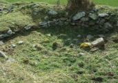
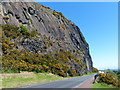
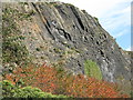
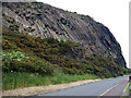
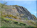
Remains of an Iron Age promontory fort are located on a narrow rocky ridge south of Arthur's Seat. They include a barely recognizable trace of the rampart and two circular house platforms.
Canmore entry.
You may be viewing yesterday's version of this page. To see the most up to date information please register for a free account.
")
")
")
Do not use the above information on other web sites or publications without permission of the contributor.
Nearby Images from Geograph Britain and Ireland:
©2016(licence)
©2014(licence)
©2010(licence)
©2012(licence)
©2005(licence)
The above images may not be of the site on this page, they are loaded from Geograph.
Please Submit an Image of this site or go out and take one for us!
Click here to see more info for this site
Nearby sites
Key: Red: member's photo, Blue: 3rd party photo, Yellow: other image, Green: no photo - please go there and take one, Grey: site destroyed
Download sites to:
KML (Google Earth)
GPX (GPS waypoints)
CSV (Garmin/Navman)
CSV (Excel)
To unlock full downloads you need to sign up as a Contributory Member. Otherwise downloads are limited to 50 sites.
Turn off the page maps and other distractions
Nearby sites listing. In the following links * = Image available
372m NNE 30° Arthur's Seat* Hillfort (NT27647282)
731m WNW 290° Slidey Stane (Holyrood Park)* Natural Stone / Erratic / Other Natural Feature (NT2676672765)
774m ENE 74° Delf Well* Holy Well or Sacred Spring (NT282727)
882m NNW 328° Salisbury Crags* Promontory Fort / Cliff Castle (NT27007326)
975m NE 46° Dunsapie Crag* Hillfort (NT28177316)
1.0km NE 51° Holyrood Park Stone (Edinburgh) Natural Stone / Erratic / Other Natural Feature (NT28267313)
1.1km N 3° St Anthony's Well (Edinburgh)* Holy Well or Sacred Spring (NT27527364)
1.3km NNW 344° St Margaret's Well (Edinburgh)* Holy Well or Sacred Spring (NT2713373712)
1.3km SW 235° Penny Well (Edinburgh)* Holy Well or Sacred Spring (NT26367177)
1.5km WNW 286° Edinburgh Runestone* Carving (NT2598972937)
1.6km NNW 332° Girth Cross (Canongate)* Ancient Cross (NT2673973910)
1.6km NW 322° Canongate Mercat Cross* Ancient Cross (NT2647273812)
1.7km NW 316° St John's Cross (Canongate)* Ancient Cross (NT2628873733)
1.8km WNW 296° National Museum of Scotland (Early Christian Stones)* Ancient Cross (NT2583273324)
1.8km S 179° Cat Stane (Inch)* Standing Stone (Menhir) (NT27457068)
1.9km WNW 294° National Museum of Scotland* Museum (NT2574873290)
1.9km WNW 294° National Museum of Scotland (Pictish Stones)* Museum (NT2572173302)
2.2km NNE 23° St Triduana's Wellhouse* Holy Well or Sacred Spring (NT2833274468)
2.2km SSE 156° Ravenswood Avenue* Standing Stone (Menhir) (NT2828270502)
2.3km WNW 290° Grassmarket modern menhir* Standing Stone (Menhir) (NT25337333)
2.3km WNW 289° The Portsburgh Stone* Natural Stone / Erratic / Other Natural Feature (NT25287327)
2.4km WNW 294° Stone of Scone* Marker Stone (NT253735)
2.6km WNW 294° St Margaret's Well (Edinburgh Castle)* Holy Well or Sacred Spring (NT2508273613)
2.7km ESE 116° Niddrie House* Standing Stone (Menhir) (NT29877125)
3.1km WSW 251° The Bore Stone* Marker Stone (NT2450871568)
View more nearby sites and additional images


 We would like to know more about this location. Please feel free to add a brief description and any relevant information in your own language.
 Wir möchten mehr über diese Stätte erfahren. Bitte zögern Sie nicht, eine kurze Beschreibung und relevante Informationen in Deutsch hinzuzufügen.
 Nous aimerions en savoir encore un peu sur les lieux. S'il vous plaît n'hesitez pas à ajouter une courte description et tous les renseignements pertinents dans votre propre langue.
 Quisieramos informarnos un poco más de las lugares. No dude en añadir una breve descripción y otros datos relevantes en su propio idioma.