Featured: Current Archaeology Book of the Year 2019!

Current Archaeology Book of the Year 2019!

Random Image


Al-Shobak Dolmen

Stonehenge Sacred Symbolism - Ancient Beliefs in Britain and Northern Europe

Stonehenge Sacred Symbolism - Ancient Beliefs in Britain and Northern Europe

Who's Online

There are currently, 182 guests and 1 members online.

You are a guest. To join in, please register for free by clicking here

Sponsors

<< Our Photo Pages >> Glastonbury Tor - Ancient Village or Settlement in England in Somerset

Submitted by Andy B on Tuesday, 18 October 2011  Page Views: 36968

Multi-periodSite Name: Glastonbury Tor
Country: England County: Somerset Type: Ancient Village or Settlement
Nearest Town: Glastonbury
Map Ref: ST51223861  Landranger Map Number: 182
Latitude: 51.144664N  Longitude: 2.698706W
Condition:
5Perfect
4Almost Perfect
3Reasonable but with some damage
2Ruined but still recognisable as an ancient site
1Pretty much destroyed, possibly visible as crop marks
0No data.
-1Completely destroyed
4 Ambience:
5Superb
4Good
3Ordinary
2Not Good
1Awful
0No data.
4 Access:
5Can be driven to, probably with disabled access
4Short walk on a footpath
3Requiring a bit more of a walk
2A long walk
1In the middle of nowhere, a nightmare to find
0No data.
4 Accuracy:
5co-ordinates taken by GPS or official recorded co-ordinates
4co-ordinates scaled from a detailed map
3co-ordinates scaled from a bad map
2co-ordinates of the nearest village
1co-ordinates of the nearest town
0no data
5

Internal Links:
External Links:

I have visited· I would like to visit

tlcearth MelMammen hallsifer would like to visit

NDM visited on 12th Apr 2023 - their rating: Cond: 4 Amb: 5 Access: 2

ModernExplorers visited on 20th Dec 2012 - their rating: Cond: 3 Amb: 5 Access: 3 Great views and a very peaceful energy

lichen visited on 12th Jul 2011 - their rating: Cond: 4 Amb: 4 Access: 4

jeffrep visited on 23rd May 2011 - their rating: Cond: 4 Amb: 5 Access: 3

coldrum visited on 1st Jan 2010 - their rating: Cond: 4 Amb: 5 Access: 3

Woode visited on 22nd Dec 2007 - their rating: Cond: 4 Amb: 4 Access: 3

Orcinus visited on 1st Jan 1987 - their rating: Amb: 4

fyrefly visited on 1st Jan 1975 - their rating: Cond: 4 Amb: 5 Access: 3 Stunning.

cazzyjane visited - their rating: Cond: 4 Amb: 5 Access: 3

druid visited - their rating: Cond: 5 Amb: 5 Access: 3

Elric visited - their rating: Cond: 4 Amb: 4 Access: 3

Twistytwirly visited - their rating: Cond: 4 Amb: 5 Access: 3

jlfern2 visited - their rating: Cond: 4 Amb: 4 Access: 4

lucasn visited - their rating: Cond: 4 Amb: 4 Access: 4

MicheleW visited - their rating: Cond: 4 Amb: 4 Access: 3

NickyD Ogham Bladup Tomleecee PhilipT h_fenton JimChampion TimPrevett hamish Klingon AnnabelleStar Alma23 hevveh have visited here

Average ratings for this site from all visit loggers: Condition: 4 Ambience: 4.53 Access: 3.14
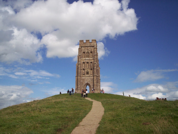
Glastonbury Tor
Glastonbury Tor submitted by coldrum : Glastonbury Tor (Vote or comment on this photo)
Glastonbury Tor is a sacred hill near Glastonbury in England which features the roofless St. Michael's Tower. The site is managed by the National Trust. The Tor has a striking location in the middle of a plain called the Summerland Meadows, part of the Somerset Levels.

Tor is a local word of Celtic origin meaning 'rock outcropping' or 'hill'. The plain is actually reclaimed fenland out of which the Tor once rose like an island, but now, with the surrounding flats, is a peninsula washed on three sides by the River Brue. The remains of Glastonbury Lake Village nearby were identified in 1892, showing that there was an Iron Age settlement about 300–200 BC on what was an easily defended island in the fens. Earthworks and Roman remains prove later occupation. The spot seems to have been called Ynys yr Afalon (meaning "The Isle of Avalon") by the Britons, and it is believed to be the Avalon of Arthurian legend.

Some Neolithic flint tools recovered from the top of the Tor show that the site has been visited and perhaps occupied throughout human prehistory. Excavations on Glastonbury Tor, undertaken by a team led by Philip Rahtz between 1964 and 1966, revealed evidence of Dark Age occupation around the later medieval church of St. Michael: postholes, two hearths including a metalworker's forge, two burials oriented north-south (thus unlikely to be Christian), fragments of 6th century Mediterranean amphorae (vases for wine or cooking oil), and a worn hollow bronze head which may have topped a Saxon staff. The Celtic name of the Tor was "Ynys Wydryn", or sometimes "Ynys Gutrin", meaning "Isle of Glass". At this time the plain was flooded, the isle becoming a peninsula at low tide.

Remains of a 5th century fort have been found on the Tor. This was replaced by the medieval St. Michael's church that remained until 1275. According to the British Geological Survey, an earthquake was recorded on 11 September 1275, which was felt in London, Canterbury and Wales and this quake destroyed the church. The quake was also reported to have destroyed many houses and churches in England, suggesting intensities greater than 7 MSK and an epicentre in the area around Portsmouth or Chichester, South England. It is possible that the shape of the tor led to a local amplification of the seismic waves where the church was situated.

A second church, built in the 1360s, survived until the Dissolution of the Monasteries in 1539 when the Tor was the place of execution where Richard Whiting the last Abbot of Glastonbury Abbey was hanged, drawn and quartered along with two of his monks. The remains of St. Michael's Tower were restored in modern times. It is a grade I listed building and is managed by the National Trust.

The site of the fair held at the foot of the Tor is embodied in the traditional name of "Fair Field" given to an agricultural enclosure, the enclosures in the local landscape dating from the 18th century.

Read more at Wikipedia

Note: Glastonbury Tor Family Muck In Day, Monday, 24 October 2011 10am - 1pm see comment.
You may be viewing yesterday's version of this page. To see the most up to date information please register for a free account.


Glastonbury Tor
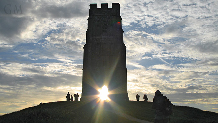
Glastonbury Tor submitted by PhilipT : A few days after Lammas, with the sun rising along the (alleged) Michael Line. Surely not a coincidence that the sun is framed by the St Michael chapel doorway at Lammas and Beltane. Canon 5D, 7 frame stitched panorama. Note that this photo has been watermarked after posting due to repeated use without permission. (14 comments - Vote or comment on this photo)

Glastonbury Tor
Glastonbury Tor submitted by PhilipGlastonbury : Glastonbury Tor From Road To Cheddar (5 comments - Vote or comment on this photo)

Glastonbury Tor
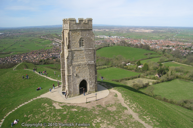
Glastonbury Tor submitted by h_fenton : The summit of Glastonbury Tor, looking down to the town of Glastonbury. A kite aerial photograph. 11 April 2010 (5 comments - Vote or comment on this photo)

Glastonbury Tor
Glastonbury Tor submitted by PhilipGlastonbury : Summer Solstice Sunrise Glastonbury Tor 2010 (Vote or comment on this photo)

Glastonbury Tor
Glastonbury Tor submitted by Thorgrim : With the ancient sacred hill of Glastonbury Tor in the background,the Holy Thorn tree on Wearyall Hill is where Joseph of Arimathea planted his staff. Just a story of course, but the thorn tree is of a type that comes from the middle east and it flowers at Christmas when a sprig is sent to the reigning monarch. A sepia treatment of this photograph gives it an antique mysterious quality and sho... (4 comments - Vote or comment on this photo)

Glastonbury Tor
Glastonbury Tor submitted by MarionBenham : Landscape Gallery Late afternoon winter sun behind Glastonbury Tor. (3 comments)

Glastonbury Tor
Glastonbury Tor submitted by Elric : Steps to Glastonbury Tor (1 comment)

Glastonbury Tor
Glastonbury Tor submitted by Elric : Sun beaming through Glastonbury Tor (1 comment)

Glastonbury Tor
Glastonbury Tor submitted by hamish : The beginnings of new life in the Glastonbury Thorn tree. Hope this lasts. (2 comments)

Glastonbury Tor
Glastonbury Tor submitted by Bladup : Glastonbury Tor. This Original Artwork in a glass frame is £39.99 + Postage (Just whatever it costs), and is 17 and a half cm x 13 cm. A limited (to a 100) edition print in a 8" x 10" glass frame would be £19.99 + £2.90 postage, E-mail me at paul.blades@rocketmail.com if interested. (3 comments)

Glastonbury Tor
Glastonbury Tor submitted by AngieLake : Peaceful scene at sunset, with Wearyall Hill in distance. (2 comments)

Glastonbury Tor
Glastonbury Tor submitted by jackdaw1 : Vale of Avalon II (2 comments)

Glastonbury Tor
Glastonbury Tor submitted by jackdaw1 : A pilgrimage. (1 comment)

Glastonbury Tor
Glastonbury Tor submitted by jackdaw1 : Vale of Avalon I

Glastonbury Tor
Glastonbury Tor submitted by jackdaw1 : One of the paths leading up to the Tor. (1 comment)

Glastonbury Tor
Glastonbury Tor submitted by jobudd : Glastonbury Tor seen from the Holy Thorn Tree on Wearyall Hill. (1 comment)

Glastonbury Tor
Glastonbury Tor submitted by sem : Based on a current animation project this shows Glastonbury Tor as it may have looked during the Neolithic ie a heavily wooded island in a marsh with no signs whatsoever of human construction. The Neolithic remains found here suggest it was used only for hunting. St Michaels church is shown purely for scale.

Glastonbury Tor
Glastonbury Tor submitted by AngieLake : The Tor and lower meadows in May 2013. (5 comments)

Glastonbury Tor
Glastonbury Tor submitted by jeffrep : St. Michael's Tower on Glastonbury Tor, Somerset, England.

Glastonbury Tor
Glastonbury Tor submitted by hamish : I was looking for a forgotten Standing Stone off of Stone Down Lane and saw this, so I took the picture.

Glastonbury Tor
Glastonbury Tor submitted by AngieLake : Not a druid... (3 comments)

Glastonbury Tor
Glastonbury Tor submitted by TimPrevett : I awoke early Sunday morning; mist hung in the streets of Glastonbury - so I *knew* that above it would be fantastic, so I got out quick, eating breakfast on the go... as I ascended the tor, the mist began thinning to give a fantastic day above. Magic. (1 comment)

Glastonbury Tor
Glastonbury Tor submitted by Uchu : The Glastonbury Tor with the directional plaque in the background and the stone relief of Michael in the foreground. (2 comments)

Glastonbury Tor
Glastonbury Tor submitted by Bladup : Glastonbury Tor.

Glastonbury Tor milestone at Wells
Glastonbury Tor milestone at Wells submitted by AngieLake : The metal insert had a bell which I didn't notice at the time! It seems to echo the design of the sweeping arches inside the Cathedral at Wells. (2 comments)

These are just the first 25 photos of Glastonbury Tor. If you log in with a free user account you will be able to see our entire collection.

Do not use the above information on other web sites or publications without permission of the contributor.
Click here to see more info for this site

Nearby sites

Click here to view sites on an interactive OS map

Key: Red: member's photo, Blue: 3rd party photo, Yellow: other image, Green: no photo - please go there and take one, Grey: site destroyed

Download sites to:
KML (Google Earth)
GPX (GPS waypoints)
CSV (Garmin/Navman)
CSV (Excel)

To unlock full downloads you need to sign up as a Contributory Member. Otherwise downloads are limited to 50 sites.


Turn off the page maps and other distractions

Nearby sites listing. In the following links * = Image available
 498m WSW 257° White Spring (Somerset)* Holy Well or Sacred Spring (ST5073238506)
 530m WSW 257° Chalice Well* Holy Well or Sacred Spring (ST507385)
 1.1km W 274° Omphalos Stone (Glastonbury Abbey)* Natural Stone / Erratic / Other Natural Feature (ST501387)
 1.2km W 280° St Joseph's Well* Holy Well or Sacred Spring (ST49993883)
 1.3km WNW 282° Glastonbury Lake Village Museum* Museum (ST499389)
 1.4km WNW 283° Market Cross (Glastonbury) Ancient Cross (ST4987538924)
 2.3km ESE 113° Ponter's Ball Dyke Ancient Village or Settlement (ST533377)
 2.8km NW 317° Glastonbury Lake Village* Ancient Village or Settlement (ST493407)
 4.7km NNE 20° Harters Hill* Ancient Trackway (ST529430)
 5.5km S 188° New Ditch* Ancient Village or Settlement (ST504332)
 7.0km SSW 203° Dundon Hill* Hillfort (ST484322)
 7.2km SSW 201° Dundon Beacon Barrow* Round Barrow(s) (ST485319)
 7.4km WNW 298° Meare Lake Village Ancient Village or Settlement (ST4472642100)
 7.9km E 90° Glastonbury Stone Circle* Modern Stone Circle etc (ST59143858)
 8.0km NNE 29° Glastonbury Tor milestone at Wells* Modern Stone Circle etc (ST552456)
 8.2km NNE 28° Wells Cathedral* Early Christian Sculptured Stone (ST5514645865)
 8.2km NNE 28° St Andrew's Well (Wells)* Holy Well or Sacred Spring (ST5522745824)
 8.3km NNE 27° Wells and Mendip Museum* Museum (ST551459)
 8.9km WNW 291° Peat Moors Centre* Museum (ST429419)
 8.9km NE 38° King's Castle (Wells) Ancient Village or Settlement (ST568456)
 9.0km WNW 287° Avalon Marshes Visitor Centre* Museum (ST426413)
 9.1km WNW 283° Sweet Track* Ancient Trackway (ST424408)
 9.3km N 11° Wookey Hole Caves Museum* Museum (ST531477)
 9.6km NNE 12° Badger Hole (Somerset) Cave or Rock Shelter (ST53244795)
 9.6km NNE 11° Wookey Hole Caves* Cave or Rock Shelter (ST53194801)
View more nearby sites and additional images

<< Cley Hill

Kinver >>

Please add your thoughts on this site

Understanding the Neolithic

Understanding the Neolithic

Sponsors

Auto-Translation (Google)

Translate from English into:

"Glastonbury Tor" | Login/Create an Account | 19 News and Comments
  
Go back to top of page    Comments are owned by the poster. We aren't responsible for their content.
Re: Glastonbury Tor by Anonymous on Wednesday, 31 October 2018
Namaste
For those also looking to understand Glastonbury, the Tor and Stonehenge from the perspective of its creation and purpose, I invite you to also explore this information:

Admin Edit - Hello Anon, I've moved your post to our Mysteries Forum, you'll find it here http://www.megalithic.co.uk/modules.php?op=modload&name=Forum&file=viewtopic&topic=7812&forum=4
[ Reply to This ]

Video by lucasn on Tuesday, 10 April 2018
(User Info | Send a Message)
https://www.youtube.com/watch?v=qehiN9Zk3Bk
[ Reply to This ]

Re: Glastonbury Tor by NickyD on Saturday, 08 August 2015
(User Info | Send a Message)
I've just spent the week in the area and visited the Tor a couple of times. There's a large irregular stone in the foundations of the tower. It looks very much like a true megalith and likely to be considering what they did at the time to try to Christianise sacred sites. There's a couple of fossils in the stone too (a shell and an ammonite), again evidence for it being used as a sacred stone! What do you think?!
[ Reply to This ]

Glastonbury Tor in the Olympic Opening Ceremony by Runemage on Friday, 27 July 2012
(User Info | Send a Message)
A symbolic replica of the Tor, with a double spiral path to its summit which was crowned with a mature oak, played a large part in the opening ceremony tonight for the Olympic Games.
[ Reply to This ]

Re: How Stone Age Man Invented The Art Of Raving by Sunny100 on Sunday, 13 May 2012
(User Info | Send a Message)
Click on the link http://www.guardian.co.uk/science/2012/may/13/scientists-stone-age-boom-festivals
[ Reply to This ]
    Re: How Stone Age Man Invented The Art Of Raving by Andy B on Sunday, 13 May 2012
    (User Info | Send a Message)
    What a strange article - Maev Kennedy wrote up the research last summer when it came out:
    http://www.guardian.co.uk/science/2011/jun/06/archaeology-dating-property-boom-3700bc

    I'm not sure what's new here apart from the 2m ERC grant and a daft headline

    A bit more about the study and the two fascinating but complex tomes it is published in
    http://www.oxbowbooks.com/bookinfo.cfm/ID/90596/OnlyResult/Yes

    Here are the locations of most of the known Causewayed Enclosures in England:
    http://www.megalithic.co.uk/search.php?country=1&sitetype=47

    See also an introductory guide to Causewayed Enclosures (PDF)
    http://www.english-heritage.org.uk/publications/iha-causewayed-enclosures/causewayedenclosures.pdf
    [ Reply to This ]
    Re: How Stone Age Man Invented The Art Of Raving by Andy B on Saturday, 19 May 2012
    (User Info | Send a Message)
    This is where the news came from - Cardiff University - I'm not sure where 'raving' fits in!

    A five-year collaborative project between Cardiff University and English Heritage that aims to construct a more precise chronology of Neolithic civilisations in Europe has just been awarded €2.5M from the European Research Council.

    The Times of Their Lives, led by Professor Alasdair Whittle of the University's School of History, Archaeology and Religion and Dr Alex Bayliss of English Heritage builds on the ground-breaking success of combining expertise in Neolithic archaeology and Bayesian statistical analysis in mapping a precise chronology of causewayed enclosures, a type of early Neolithic earthwork, in Britain.

    Causewayed enclosures are known prehistoric features, but up to now it has been thought that they spread slowly across Britain over five centuries. Using the new technique, Professor Whittle and Dr Bayliss have already shown that this new class of huge monuments spread rapidly all over southern Britain in a short span of 75 years, starting from the Thames Estuary through Kent and Sussex, and then west, on an intense scale that was not apparent before. The new knowledge that this happened in a flurry within two to three generations has revolutionised the way prehistory is understood and studied in Britain, and has prompted wide interest around the world.

    "At stake is our ability to study the lives of Neolithic people at the scale of generations and even decades, as opposed to the more usual scale of centuries," said Professor Whittle of the University's Department of Archaeology and Conservation.

    "The Neolithic period in Europe, as elsewhere globally, is of enduring interest because it presents one of the great transformations in human history: over time, from small-scale, probably often mobile and egalitarian hunter-gatherer communities to complex, variously hierarchical societies materially based on sedentary existence and a farming economy. The Times of Their Lives project will concentrate on the development of this way of life, rather on its initiation."

    The research team will focus on examining sites in Serbia, Hungary, Poland, Switzerland, Austria, Germany, France, Spain and Malta, with the help and cooperation of European partners. These will include deeply stratified settlement mounds or tells, other 'flat' settlements, cemeteries, megalithic monuments, and ditched enclosures. The dated pollen diagrams of England will also be modelled.

    Explaining their novel research approach, Dr Alex Bayliss of English Heritage said: "Based on the eighteenth-century theorem of Thomas Bayes, the Bayesian methodology we're using combines radiocarbon dates with prior archaeological knowledge of dated samples to produce formally modelled date estimates of the events and phenomena in any given sequence. The rigorous application of this model will enable the calculation of quantified date estimates, which are both much more precise and more reliable than those obtained by simply looking at radiocarbon results."

    The research will also draw on the expertise of a team of archaeologists in Cardiff and statistical modellers in London. As well as producing a clearer picture of the lives of our ancestors, Professor Whittle and Dr Bayliss aim to leave a legacy of best practice in relation to their chosen methodology and its effect on our understanding of the issues of chronology and time.
    [ Reply to This ]
      Re: How Stone Age Man Invented The Art Of Raving by Sunny100 on Saturday, 19 May 2012
      (User Info | Send a Message)
      No I'm not sure why neither Andy. It just made a good headline for the newspaper. Maybe some connection with Glastonbury and festivals ?
      [ Reply to This ]

Glastonbury Tor Family Muck In Day, Monday, 24 October 2011 10am - 1pm by coldrum on Tuesday, 18 October 2011
(User Info | Send a Message)
Glastonbury Tor Family Muck In Day, Monday, 24 October 2011 10am - 1pm

Glastonbury Tor
Family Muck In Day
Monday, 24 October 2011 10am - 1pm
Join our ranger and get stuck in helping to pick apples from the orchards at the bottom of Glastonbury Tor. Have a go at pressing and crushing your own apples too. Takes place on the 24th October, 10 till 1pm.

More Information: Carole Elliott, 01643 862452 press 1, carole.elliott@nationaltrust.org.uk


# Booking Essential 01643 862452 press 1
# Suitable for Groups
# Please wear warm waterproof clothing that you don't mind getting muddy.

http://www.nationaltrust.org.uk/main/w-vh/w-visits/w-events/w-events-find_event.htm
[ Reply to This ]

Re: Glastonbury Tor to get new hedges and trees by Flint on Thursday, 10 March 2011
(User Info | Send a Message)
Might want to check out the huge network of caves that are below the Tor.
[ Reply to This ]

Re: Glastonbury Tor to get new hedges and trees by SueKing on Saturday, 27 November 2010
(User Info | Send a Message)
Nice choice of trees but how about losing one of the field maples and adding elder? Birds and badgers love the berries.
[ Reply to This ]

Re: Glastonbury Tor to get new hedges and trees by MikeGreen on Saturday, 27 November 2010
(User Info | Send a Message)
I guess most places change so much over a period of millenia that you could manage it in almost anyway you like and claim you were reflecting the "Good old days" - This is not a cynics observation - I just make the point
[ Reply to This ]

Glastonbury Tor to get new hedges and trees by davidmorgan on Tuesday, 23 November 2010
(User Info | Send a Message)
Two thousand trees are going to be planted on the bottom slopes of Glastonbury Tor, in a hark back to the area's traditional roots.

On Saturday, 20 November, volunteers and staff at the National Trust will begin the three-week project in one of the southern fields.

Organisers hope the mass-planting will "be an eye-catching reminder of yesteryear".

The new hedges will follow the "remnant lines of ancient field systems", helping the Tor to resemble its former look two centuries ago.

Then, there was a tradition of many small fields in the ownership of local people in Glastonbury.

The share cropping system allowed rural dwellers to supplement their income from the land.

TREES TO BE PLANTED
Oak tree
Hazel
Hawthorn
Blackthorn
Field maple
Common buckthorn
Spindle
Dog rose
Guelder rose
Standard oak
Ash
Field maple
The hedges will be a mix of species reflecting the local hedges

It is also helped that the trees will have a positive impact on local wildlife, while helping the natural environment.

The trees will not only create food and shelter for birds and insects, but each year the hedges will grow by capturing carbon from the atmosphere.

There are plans to create four small paddocks with the new hedgerows, which will help the National Trust to set up a sustainable grazing regime using sheep.

"This is an exciting project," said Rob Holden from the National Trust.

"[It] will not only help to capture the traditions of this legendary site but will provide valuable habitat for wildlife and have a long term benefit for the wider natural environment.

"We're really looking forward to the first day and working with so many dedicated volunteers."

Local volunteer group, the Glastonbury Conservation Society is also supporting the project.

The society has been so active in restoring hedgerows around the area that supporters are now nearing their 50,000th tree.

http://news.bbc.co.uk/local/somerset/hi/people_and_places/nature/newsid_9209000/9209863.stm

Submitted by coldrum.
[ Reply to This ]

Street View by coldrum on Wednesday, 17 March 2010
(User Info | Send a Message)

View Larger Map
[ Reply to This ]

Re: Glastonbury Tor by coldrum on Tuesday, 06 October 2009
(User Info | Send a Message)
http://www.pastscape.org.uk/hob.aspx?hob_id=196695
[ Reply to This ]

Re: Glastonbury Tor by coldrum on Tuesday, 06 October 2009
(User Info | Send a Message)
Pastscape entry:

http://www.pastscape.org.uk/hob.aspx?hob_id=196702
[ Reply to This ]

Re: Glastonbury Tor by Anonymous on Friday, 11 August 2006
Have people investigated to learn to what extent this is a geologically natural hill?
[ Reply to This ]
    Re: Glastonbury Tor by JimChampion on Friday, 11 August 2006
    (User Info | Send a Message)
    Yes. There is a rational discussion of the Tor and its history (geological and archaeological) in chapters 2 and 6 of the book "Glastonbury" by Philip Rahtz (part of an English Heritage series, published in 1993, in a library near you probably). From the bottom up it is lower lias clay, middle lias limestone, upper lias clay with a capping of midford sandstone. The top part has probably survived erosion over the millenia because it was hardened by iron compounds from the spring that now feeds Chalice Well. The underlying soft lias strata mean that it is unstable and vulnerable to earthquakes (such as that which destroyed one of the churches on the summit).

    Archaeological excavations have revealed a lot about human activity on the Tor, going back to the Upper Paleolithic, but nothing has been found to support the more far fetched ideas about the Tor (it is hollow, it was artificially made (like Silbury), the terraces were created as a huge labyrinth).
    [ Reply to This ]

Re: Glastonbury Tor by Anonymous on Thursday, 16 December 2004
on a 1902 audinanace survey map of glastonbury, there is a half a stone circle shown on windmill hill that now have houses built on them. on the winter solstice sunrise, filmed from one of these houses. shows the sun sits in each of the ridges on the tor that were previosly belived to be a maze. the sun then eclipses with the tower, sun bursts and begins its accent into the sky. also five minuets before the actual sun rise the dawn chorus of bird song is immense!!!
If you would like to contact me my E-mail address is Kenheaton1@yahoo.co.uk
[ Reply to This ]

Your Name: Anonymous [ Register Now ]
Subject:


Add your comment or contribution to this page. Spam or offensive posts are deleted immediately, don't even bother

<<< What is five plus one as a number? (Please type the answer to this question in the little box on the left)
You can also embed videos and other things. For Youtube please copy and paste the 'embed code'.
For Google Street View please include Street View in the text.
Create a web link like this: <a href="https://www.megalithic.co.uk">This is a link</a>  

Allowed HTML is:
<p> <b> <i> <a> <img> <em> <br> <strong> <blockquote> <tt> <li> <ol> <ul> <object> <param> <embed> <iframe>

We would like to know more about this location. Please feel free to add a brief description and any relevant information in your own language.
Wir möchten mehr über diese Stätte erfahren. Bitte zögern Sie nicht, eine kurze Beschreibung und relevante Informationen in Deutsch hinzuzufügen.
Nous aimerions en savoir encore un peu sur les lieux. S'il vous plaît n'hesitez pas à ajouter une courte description et tous les renseignements pertinents dans votre propre langue.
Quisieramos informarnos un poco más de las lugares. No dude en añadir una breve descripción y otros datos relevantes en su propio idioma.