


<< Our Photo Pages >> Omphalos Stone (Glastonbury Abbey) - Natural Stone / Erratic / Other Natural Feature in England in Somerset
Submitted by hamish on Thursday, 16 June 2005 Page Views: 15315
Natural PlacesSite Name: Omphalos Stone (Glastonbury Abbey)Country: England
NOTE: This site is 2.702 km away from the location you searched for.
County: Somerset Type: Natural Stone / Erratic / Other Natural Feature
Nearest Town: Glastonbury
Map Ref: ST501387
Latitude: 51.145376N Longitude: 2.714728W
Condition:
| 5 | Perfect |
| 4 | Almost Perfect |
| 3 | Reasonable but with some damage |
| 2 | Ruined but still recognisable as an ancient site |
| 1 | Pretty much destroyed, possibly visible as crop marks |
| 0 | No data. |
| -1 | Completely destroyed |
| 5 | Superb |
| 4 | Good |
| 3 | Ordinary |
| 2 | Not Good |
| 1 | Awful |
| 0 | No data. |
| 5 | Can be driven to, probably with disabled access |
| 4 | Short walk on a footpath |
| 3 | Requiring a bit more of a walk |
| 2 | A long walk |
| 1 | In the middle of nowhere, a nightmare to find |
| 0 | No data. |
| 5 | co-ordinates taken by GPS or official recorded co-ordinates |
| 4 | co-ordinates scaled from a detailed map |
| 3 | co-ordinates scaled from a bad map |
| 2 | co-ordinates of the nearest village |
| 1 | co-ordinates of the nearest town |
| 0 | no data |
Internal Links:
External Links:
I have visited· I would like to visit
hallsifer would like to visit
Ogham visited on 11th Jan 0009 - their rating: Cond: 3 Amb: 4 Access: 4
jlfern2 visited - their rating: Cond: 4 Amb: 3 Access: 4
hamish have visited here
Average ratings for this site from all visit loggers: Condition: 3.5 Ambience: 3.5 Access: 4
 (PID:14767)")
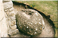
Found at the rear of the Abbott's Kitchen in Glastonbury Abbey. It is a Tor Burr with a slot cut into the top for a cross.
You may be viewing yesterday's version of this page. To see the most up to date information please register for a free account.
 (PID:14769)")
 (PID:14768)")
Do not use the above information on other web sites or publications without permission of the contributor.
Nearby Images from Geograph Britain and Ireland:
©2008(licence)
©2008(licence)
©2018(licence)

©2018(licence)
©2018(licence)
The above images may not be of the site on this page, they are loaded from Geograph.
Please Submit an Image of this site or go out and take one for us!
Click here to see more info for this site
Nearby sites
Key: Red: member's photo, Blue: 3rd party photo, Yellow: other image, Green: no photo - please go there and take one, Grey: site destroyed
Download sites to:
KML (Google Earth)
GPX (GPS waypoints)
CSV (Garmin/Navman)
CSV (Excel)
To unlock full downloads you need to sign up as a Contributory Member. Otherwise downloads are limited to 50 sites.
Turn off the page maps and other distractions
Nearby sites listing. In the following links * = Image available
170m NW 319° St Joseph's Well* Holy Well or Sacred Spring (ST49993883)
282m NW 315° Glastonbury Lake Village Museum* Museum (ST499389)
317m NW 314° Market Cross (Glastonbury) Ancient Cross (ST4987538924)
631m ESE 108° Chalice Well* Holy Well or Sacred Spring (ST507385)
659m ESE 107° White Spring (Somerset)* Holy Well or Sacred Spring (ST5073238506)
1.1km E 94° Glastonbury Tor* Ancient Village or Settlement (ST51223861)
2.2km NNW 338° Glastonbury Lake Village* Ancient Village or Settlement (ST493407)
3.3km ESE 107° Ponter's Ball Dyke Ancient Village or Settlement (ST533377)
5.1km NNE 32° Harters Hill* Ancient Trackway (ST529430)
5.5km S 176° New Ditch* Ancient Village or Settlement (ST504332)
6.3km WNW 302° Meare Lake Village Ancient Village or Settlement (ST4472642100)
6.7km SSW 194° Dundon Hill* Hillfort (ST484322)
7.0km SSW 193° Dundon Beacon Barrow* Round Barrow(s) (ST485319)
7.9km WNW 293° Peat Moors Centre* Museum (ST429419)
7.9km WNW 289° Avalon Marshes Visitor Centre* Museum (ST426413)
8.0km WNW 285° Sweet Track* Ancient Trackway (ST424408)
8.6km NE 36° Glastonbury Tor milestone at Wells* Modern Stone Circle etc (ST552456)
8.8km NE 35° Wells Cathedral* Early Christian Sculptured Stone (ST5514645865)
8.8km NE 34° Wells and Mendip Museum* Museum (ST551459)
8.8km NE 35° St Andrew's Well (Wells)* Holy Well or Sacred Spring (ST5522745824)
9.0km E 90° Glastonbury Stone Circle* Modern Stone Circle etc (ST59143858)
9.0km WNW 294° Abbot's Way* Ancient Trackway (ST419425)
9.5km NNE 18° Wookey Hole Caves Museum* Museum (ST531477)
9.6km NE 44° King's Castle (Wells) Ancient Village or Settlement (ST568456)
9.7km SSW 211° High Ham Cursus Cursus (ST45013048)
View more nearby sites and additional images


 We would like to know more about this location. Please feel free to add a brief description and any relevant information in your own language.
 Wir möchten mehr über diese Stätte erfahren. Bitte zögern Sie nicht, eine kurze Beschreibung und relevante Informationen in Deutsch hinzuzufügen.
 Nous aimerions en savoir encore un peu sur les lieux. S'il vous plaît n'hesitez pas à ajouter une courte description et tous les renseignements pertinents dans votre propre langue.
 Quisieramos informarnos un poco más de las lugares. No dude en añadir una breve descripción y otros datos relevantes en su propio idioma.