

<< Our Photo Pages >> Inchmarlo - Standing Stone (Menhir) in Scotland in Aberdeenshire
Submitted by cosmic on Sunday, 27 November 2005 Page Views: 6420
Neolithic and Bronze AgeSite Name: InchmarloCountry: Scotland
NOTE: This site is 1.684 km away from the location you searched for.
County: Aberdeenshire Type: Standing Stone (Menhir)
Nearest Town: Banchory
Map Ref: NO68249613
Latitude: 57.055127N Longitude: 2.525209W
Condition:
| 5 | Perfect |
| 4 | Almost Perfect |
| 3 | Reasonable but with some damage |
| 2 | Ruined but still recognisable as an ancient site |
| 1 | Pretty much destroyed, possibly visible as crop marks |
| 0 | No data. |
| -1 | Completely destroyed |
| 5 | Superb |
| 4 | Good |
| 3 | Ordinary |
| 2 | Not Good |
| 1 | Awful |
| 0 | No data. |
| 5 | Can be driven to, probably with disabled access |
| 4 | Short walk on a footpath |
| 3 | Requiring a bit more of a walk |
| 2 | A long walk |
| 1 | In the middle of nowhere, a nightmare to find |
| 0 | No data. |
| 5 | co-ordinates taken by GPS or official recorded co-ordinates |
| 4 | co-ordinates scaled from a detailed map |
| 3 | co-ordinates scaled from a bad map |
| 2 | co-ordinates of the nearest village |
| 1 | co-ordinates of the nearest town |
| 0 | no data |
Internal Links:
External Links:
")
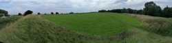
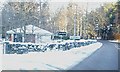
This standing stone is all that remains of a stone circle that was destroyed around 1800. It stands in the front garden of the west most of the two houses to the south of the Ballater road just beyond the 30mph sign coming out of Banchory.
The stone is some 8 feet high. It had a "post box" cut into it at some point (top right as you look at photo).
You may be viewing yesterday's version of this page. To see the most up to date information please register for a free account.
")
Do not use the above information on other web sites or publications without permission of the contributor.
coldrum has found this location on Google Street View:
Nearby Images from Geograph Britain and Ireland:
©2009(licence)
©2009(licence)
©2009(licence)
©2009(licence)
©2007(licence)
The above images may not be of the site on this page, they are loaded from Geograph.
Please Submit an Image of this site or go out and take one for us!
Click here to see more info for this site
Nearby sites
Key: Red: member's photo, Blue: 3rd party photo, Yellow: other image, Green: no photo - please go there and take one, Grey: site destroyed
Download sites to:
KML (Google Earth)
GPX (GPS waypoints)
CSV (Garmin/Navman)
CSV (Excel)
To unlock full downloads you need to sign up as a Contributory Member. Otherwise downloads are limited to 50 sites.
Turn off the page maps and other distractions
Nearby sites listing. In the following links * = Image available
3.9km SW 216° Bucharn* Round Cairn (NO65949300)
4.5km ESE 117° Tilquhillie Standing Stone* Standing Stone (Menhir) (NO72239410)
4.8km ESE 116° Tilquhillie Stone Circle (Remains)* Stone Circle (NO72529402)
4.9km NW 316° Glassel* Stone Circle (NO64909969)
5.0km E 92° Balbridie Neolithic Timber Hall Ancient Village or Settlement (NO733959)
5.6km SE 134° Esslie The Lesser* Stone Circle (NO72259215)
5.7km E 84° Warren Field* Ancient Village or Settlement (NO73939670)
5.7km SE 142° Esslie The Greater* Stone Circle (NO71729159)
5.8km E 90° Milton of Crathes* Class I Pictish Symbol Stone (NO741961)
5.9km ESE 110° Cairnshee Enclosure Souterrain (Fogou, Earth House) (NO738941)
6.0km ESE 103° Barns Enclosure Ancient Village or Settlement (NO741947)
6.2km ESE 112° Cairnshee Wood* Cairn (NO740937)
6.4km SE 126° East Mulloch Stone Circle (NO734923)
6.5km SE 140° Garrol Wood* Stone Circle (NO72409117)
6.7km SSE 150° Midtown Ancient Village or Settlement (NO715903)
6.7km SE 145° Midtown Ancient Village or Settlement (NO720906)
6.8km SE 131° Westerton Hut Circle Ancient Village or Settlement (NO733916)
7.2km W 269° Inchbaire Stone Circle (NO610960)
7.4km ESE 105° Cairnfauld* Stone Circle (NO754941)
7.5km NW 325° Craigmyle* Class I Pictish Symbol Stone (NJ64020235)
8.8km WSW 256° Corsedardar* Standing Stone (Menhir) (NO59709405)
9.0km WSW 256° Dardannus Stone* Standing Stone (Menhir) (NO595940)
9.2km NW 319° Learney Standing Stone* Standing Stone (Menhir) (NJ62290318)
9.4km WSW 255° Finzean House* Chambered Cairn (NO591937)
9.5km W 261° Berrysloch* Standing Stone (Menhir) (NO588947)
View more nearby sites and additional images


 We would like to know more about this location. Please feel free to add a brief description and any relevant information in your own language.
 Wir möchten mehr über diese Stätte erfahren. Bitte zögern Sie nicht, eine kurze Beschreibung und relevante Informationen in Deutsch hinzuzufügen.
 Nous aimerions en savoir encore un peu sur les lieux. S'il vous plaît n'hesitez pas à ajouter une courte description et tous les renseignements pertinents dans votre propre langue.
 Quisieramos informarnos un poco más de las lugares. No dude en añadir una breve descripción y otros datos relevantes en su propio idioma.