


<< Our Photo Pages >> Bill Hill (Berkshire) - Round Barrow(s) in England in Berkshire
Submitted by wiztwas on Tuesday, 03 October 2006 Page Views: 15148
Neolithic and Bronze AgeSite Name: Bill Hill (Berkshire)Country: England
NOTE: This site is 1.9 km away from the location you searched for.
County: Berkshire Type: Round Barrow(s)
Nearest Town: Bracknell
Map Ref: SU868683
Latitude: 51.407093N Longitude: 0.753448W
Condition:
| 5 | Perfect |
| 4 | Almost Perfect |
| 3 | Reasonable but with some damage |
| 2 | Ruined but still recognisable as an ancient site |
| 1 | Pretty much destroyed, possibly visible as crop marks |
| 0 | No data. |
| -1 | Completely destroyed |
| 5 | Superb |
| 4 | Good |
| 3 | Ordinary |
| 2 | Not Good |
| 1 | Awful |
| 0 | No data. |
| 5 | Can be driven to, probably with disabled access |
| 4 | Short walk on a footpath |
| 3 | Requiring a bit more of a walk |
| 2 | A long walk |
| 1 | In the middle of nowhere, a nightmare to find |
| 0 | No data. |
| 5 | co-ordinates taken by GPS or official recorded co-ordinates |
| 4 | co-ordinates scaled from a detailed map |
| 3 | co-ordinates scaled from a bad map |
| 2 | co-ordinates of the nearest village |
| 1 | co-ordinates of the nearest town |
| 0 | no data |
Internal Links:
External Links:
I have visited· I would like to visit
pakita13130 would like to visit
SolarMegalith visited on 24th Jan 2011 - their rating: Cond: 3 Amb: 3 Access: 4
 (PID:72924)")
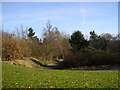
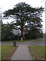
Bill Hill is a very large hill located just off Downshire Way. Few people passing it would realise that this huge hill is an ancient monument. At the top of the hill, on its eastern side, is a circular mound of earth, hollowed out in the centre. This the remains of a Bronze Age bowl barrow. The hollow may well have been the result of an early unrecorded excavation. The Bill Hill barrow is surrounded by a ditch, now largely filled in, which would have provided construction material for the mound.
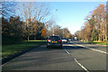
Whilst easy to drive past, it is alongside Downshire Way a main through route in Bracknell (A3095) it is not so easy to visit as there is no obvious parking area nearby. The best place to park is in Crowthorne Road to the north east of the mound. (Near the Green Man Pub). The area is pretty unattractive at ground level, dominated by a cycleway / foot path alongside the main road and a good helping of litter. Climbing up the hill can be via one of several paths, some more engineered with steps than others. Once at the top of the hill it would be hard to believe you are in the heart of a major town were it not for the traffic noise.
Bill Hill is a Scheduled Ancient Monument.
Bracknell forest web site contains more info.
You may be viewing yesterday's version of this page. To see the most up to date information please register for a free account.
 (PID:72927)")
 (PID:72926)")
 (PID:72925)")
Do not use the above information on other web sites or publications without permission of the contributor.
Nearby Images from Geograph Britain and Ireland:

©2024(licence)
©2009(licence)
©2017(licence)

©2024(licence)
©2006(licence)
The above images may not be of the site on this page, they are loaded from Geograph.
Please Submit an Image of this site or go out and take one for us!
Click here to see more info for this site
Nearby sites
Key: Red: member's photo, Blue: 3rd party photo, Yellow: other image, Green: no photo - please go there and take one, Grey: site destroyed
Download sites to:
KML (Google Earth)
GPX (GPS waypoints)
CSV (Garmin/Navman)
CSV (Excel)
To unlock full downloads you need to sign up as a Contributory Member. Otherwise downloads are limited to 50 sites.
Turn off the page maps and other distractions
Nearby sites listing. In the following links * = Image available
2.2km SW 218° Woodenhill Plantation Barrow Round Barrow(s) (SU85496656)
2.4km ESE 109° Swinley Park Barrow* Round Barrow(s) (SU89106754)
2.5km N 6° The Quelm Stone* Natural Stone / Erratic / Other Natural Feature (SU870708)
2.6km SSW 192° Caesar's Camp (Berkshire)* Hillfort (SU863657)
4.5km E 86° Bowledge Hill Bell Barrow* Round Barrow(s) (SU91336872)
5.1km NNE 28° Holyport Modern Stone Circle Modern Stone Circle etc (SU8908672865)
8.4km WSW 245° Warren Lodge Barrows* Round Barrow(s) (SU7925664643)
8.6km ESE 104° Sunningdale Barrows Round Barrow(s) (SU952664)
9.3km SE 139° West End Common Barrows* Barrow Cemetery (SU931614)
9.8km SE 137° New England Barrow Round Barrow(s) (SU93616129)
10.1km SSW 202° Round Barrow near Blackwater Round Barrow(s) (SU8310158871)
10.3km SSW 205° Ancient field boundaries near Blackwater Misc. Earthwork (SU8257058911)
10.4km SSW 203° Hornley Common* Round Barrow(s) (SU8291758669)
11.2km E 93° Leptis Magna (Virginia Waters)* Ancient Temple (SU980680)
11.3km ESE 112° Albury Bottom Enclosure* Misc. Earthwork (SU97426430)
11.5km NNE 22° Weir Bank Stud Farm Ancient Village or Settlement (SU90957900)
11.5km SW 231° Eversley Church Sarsen Stone* Natural Stone / Erratic / Other Natural Feature (SU7791060924)
12.3km ESE 103° Barrowhills Round Barrow(s) (SU98866567)
12.3km N 353° Maidenhead Thicket Bowl Barrow* Round Barrow(s) (SU850805)
12.4km SE 136° St John the Baptist's Well (Bisley)* Holy Well or Sacred Spring (SU956595)
12.6km NW 308° Sonning Cursus Cursus (SU767759)
12.8km ESE 105° Flutters Hill Barrow* Round Barrow(s) (SU99206516)
12.8km NW 307° Sonning Cursus Cursus (SU765759)
12.8km ESE 107° Longcross Barrow* Round Barrow(s) (SU99126466)
12.9km N 354° Robin Hood's Arbour* Ancient Village or Settlement (SU85188108)
View more nearby sites and additional images


 We would like to know more about this location. Please feel free to add a brief description and any relevant information in your own language.
 Wir möchten mehr über diese Stätte erfahren. Bitte zögern Sie nicht, eine kurze Beschreibung und relevante Informationen in Deutsch hinzuzufügen.
 Nous aimerions en savoir encore un peu sur les lieux. S'il vous plaît n'hesitez pas à ajouter une courte description et tous les renseignements pertinents dans votre propre langue.
 Quisieramos informarnos un poco más de las lugares. No dude en añadir una breve descripción y otros datos relevantes en su propio idioma.