


<< Text Pages >> Ragpit Cross Dyke - Misc. Earthwork in England in Buckinghamshire
Submitted by coldrum on Monday, 30 August 2010 Page Views: 3661
Multi-periodSite Name: Ragpit Cross DykeCountry: England
NOTE: This site is 0.6 km away from the location you searched for.
County: Buckinghamshire Type: Misc. Earthwork
Map Ref: SP83020598
Latitude: 51.746378N Longitude: 0.798887W
Condition:
| 5 | Perfect |
| 4 | Almost Perfect |
| 3 | Reasonable but with some damage |
| 2 | Ruined but still recognisable as an ancient site |
| 1 | Pretty much destroyed, possibly visible as crop marks |
| 0 | No data. |
| -1 | Completely destroyed |
| 5 | Superb |
| 4 | Good |
| 3 | Ordinary |
| 2 | Not Good |
| 1 | Awful |
| 0 | No data. |
| 5 | Can be driven to, probably with disabled access |
| 4 | Short walk on a footpath |
| 3 | Requiring a bit more of a walk |
| 2 | A long walk |
| 1 | In the middle of nowhere, a nightmare to find |
| 0 | No data. |
| 5 | co-ordinates taken by GPS or official recorded co-ordinates |
| 4 | co-ordinates scaled from a detailed map |
| 3 | co-ordinates scaled from a bad map |
| 2 | co-ordinates of the nearest village |
| 1 | co-ordinates of the nearest town |
| 0 | no data |
Be the first person to rate this site - see the 'Contribute!' box in the right hand menu.
Internal Links:
External Links:
Misc. Earthwork in Buckinghamshire
From Pastscape:
"Prehistoric multivallate cross dyke, oreintated north east to south west, extending for circa 140m between the upper slopes of the steep natural scarps on either side of the spur. The ditch averages 5m in width and 1.2m in depth, being flanked on western side by an earthen bank between 4m and 7m across and reaching a maximum height of 0.7m. The dyke is breached in two places. A hollow way, some 2m in depth, thought to be medieval, truncates the point some 30m from the northern end. A causeway 40m further south carries a modern road which runs parallel to the hollow wayThe eartworks are less clearly defined immediately either side of the road, probably due to spoil from the construction. Another cross dyke runs parallel to this one some 250m to thewest."
Pastscape
You may be viewing yesterday's version of this page. To see the most up to date information please register for a free account.
Do not use the above information on other web sites or publications without permission of the contributor.
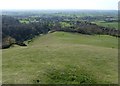
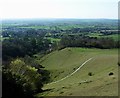
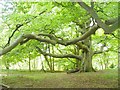
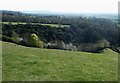
Nearby Images from Geograph Britain and Ireland:
©2015(licence)
©2015(licence)
©2017(licence)
©2017(licence)
©2015(licence)
The above images may not be of the site on this page, they are loaded from Geograph.
Please Submit an Image of this site or go out and take one for us!
Click here to see more info for this site
Nearby sites
Key: Red: member's photo, Blue: 3rd party photo, Yellow: other image, Green: no photo - please go there and take one, Grey: site destroyed
Download sites to:
KML (Google Earth)
GPX (GPS waypoints)
CSV (Garmin/Navman)
CSV (Excel)
To unlock full downloads you need to sign up as a Contributory Member. Otherwise downloads are limited to 50 sites.
Turn off the page maps and other distractions
Nearby sites listing. In the following links * = Image available
270m W 275° Ragpit Cross Dykes Misc. Earthwork (SP82750600)
271m W 277° Ragpit Hill Cross Dyke Misc. Earthwork (SP82750601)
996m S 171° Pulpit Hill* Hillfort (SP832050)
2.2km SSW 203° Whiteleaf Barrows* Long Barrow (SP82220398)
3.3km ENE 71° Bacombe Hill Bowl Barrow Round Barrow(s) (SP86130709)
3.3km SW 219° Princes Risborough Puddingstone* Natural Stone / Erratic / Other Natural Feature (SP80970338)
3.3km ENE 71° Bacombe Hill Barrow Cemetery (SP86160712)
4.8km SSE 147° Grim's Ditch Barrows Round Barrow(s) (SP857020)
5.5km ENE 70° Boddington Camp* Hillfort (SP882080)
6.4km SW 235° The Lyde Spring* Holy Well or Sacred Spring (SP778022)
6.5km SSE 148° Stonygreen Puddingstone Natural Stone / Erratic / Other Natural Feature (SP866005)
6.7km SSE 158° Denner Hill Puddingstone Natural Stone / Erratic / Other Natural Feature (SU857998)
6.9km SSW 212° Lodge Hill Round Barrow(s) (SP79400004)
7.0km SW 218° Lodge Hill Barrows Round Barrow(s) (SP78840041)
7.0km SSW 211° Lodge Hill Settlement Ancient Village or Settlement (SU79479990)
7.5km SW 230° The Cop (Chinnor) Round Barrow(s) (SP773011)
7.5km NNW 332° Hartwell Springs* Holy Well or Sacred Spring (SP7939412589)
7.8km S 179° Chilterns Grims Ditch* Misc. Earthwork (SU833982)
7.9km SSW 191° Smalldean Round Barrow(s) (SU816982)
8.2km SW 230° Chinnor Hill Barrows* Round Barrow(s) (SP76760063)
8.9km S 182° Bradenham Puddingstone* Natural Stone / Erratic / Other Natural Feature (SU828971)
9.2km N 5° St. Osyth's Well (Bierton)* Holy Well or Sacred Spring (SP836152)
9.9km ESE 123° Great Missenden Puddingstone* Natural Stone / Erratic / Other Natural Feature (SP9142700686)
10.0km E 84° Cholesbury Camp* Hillfort (SP930072)
10.2km WNW 297° Cuddington Spring Holy Well or Sacred Spring (SP739105)
View more nearby sites and additional images


 We would like to know more about this location. Please feel free to add a brief description and any relevant information in your own language.
 Wir möchten mehr über diese Stätte erfahren. Bitte zögern Sie nicht, eine kurze Beschreibung und relevante Informationen in Deutsch hinzuzufügen.
 Nous aimerions en savoir encore un peu sur les lieux. S'il vous plaît n'hesitez pas à ajouter une courte description et tous les renseignements pertinents dans votre propre langue.
 Quisieramos informarnos un poco más de las lugares. No dude en añadir una breve descripción y otros datos relevantes en su propio idioma.