


<< Our Photo Pages >> Rawcliffe Howe - Cairn in England in Yorkshire (North)
Submitted by vagabondnma on Tuesday, 13 March 2007 Page Views: 3969
Neolithic and Bronze AgeSite Name: Rawcliffe HoweCountry: England County: Yorkshire (North) Type: Cairn
Nearest Town: Newton-On-Rawcliffe Nearest Village: Cropton
Map Ref: SE799912
Latitude: 54.310156N Longitude: 0.773437W
Condition:
| 5 | Perfect |
| 4 | Almost Perfect |
| 3 | Reasonable but with some damage |
| 2 | Ruined but still recognisable as an ancient site |
| 1 | Pretty much destroyed, possibly visible as crop marks |
| 0 | No data. |
| -1 | Completely destroyed |
| 5 | Superb |
| 4 | Good |
| 3 | Ordinary |
| 2 | Not Good |
| 1 | Awful |
| 0 | No data. |
| 5 | Can be driven to, probably with disabled access |
| 4 | Short walk on a footpath |
| 3 | Requiring a bit more of a walk |
| 2 | A long walk |
| 1 | In the middle of nowhere, a nightmare to find |
| 0 | No data. |
| 5 | co-ordinates taken by GPS or official recorded co-ordinates |
| 4 | co-ordinates scaled from a detailed map |
| 3 | co-ordinates scaled from a bad map |
| 2 | co-ordinates of the nearest village |
| 1 | co-ordinates of the nearest town |
| 0 | no data |
Internal Links:
External Links:
I have visited· I would like to visit
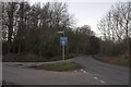
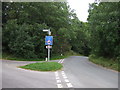
Anne T visited on 1st Oct 2016 - their rating: Cond: 2 Amb: 2 Access: 5 Rawcliffe Howe, south of Stape Village, North Yorkshire: No entry exists for Rawcliffe Howe on the ADS, but does on Historic England. From Old Wives’ Well, driving southwards back down through the Village of Stape, we came to a four way cross-roads. Parking in a small layby just as we turned into Low Moor Road, where on the opposite side of the road a footpath runs through the wood leading to Rawcliffe Banks. I used the photographs from the mobile Portal site to help locate this.
This round barrow sits right on the edge of the road opposite the entrance to Low Moor Road and has clearly been cut through by the road. Trying to photograph it was very tricky as the rally cars were coming in groups thick and fast, and at one point I jumped further onto the verge to avoid a car that nearly missed the turning!
We managed to get photographs from various angles, although if I hadn’t known this was a site from the Portal would have missed it entirely.
")
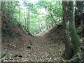
Oh Dear! Despite the map showing the road missing the howe, infact it cuts through it. This is because the road is in a deep cut and the howe loses a great deal of it's earth because of it.
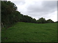
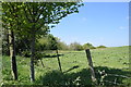
The first picture shows it from the road, the second shows how much is missing due to the road. This is pasture land, unlike the other howes near-by which are in woodland. Because of this, it's original shape is much less clear and it is merely seen as a small mound.
You may be viewing yesterday's version of this page. To see the most up to date information please register for a free account.
")
")
")
")
Do not use the above information on other web sites or publications without permission of the contributor.
Nearby Images from Geograph Britain and Ireland:
©2012(licence)
©2018(licence)
©2018(licence)
©2007(licence)
©2012(licence)
The above images may not be of the site on this page, they are loaded from Geograph.
Please Submit an Image of this site or go out and take one for us!
Click here to see more info for this site
Nearby sites
Key: Red: member's photo, Blue: 3rd party photo, Yellow: other image, Green: no photo - please go there and take one, Grey: site destroyed
Download sites to:
KML (Google Earth)
GPX (GPS waypoints)
CSV (Garmin/Navman)
CSV (Excel)
To unlock full downloads you need to sign up as a Contributory Member. Otherwise downloads are limited to 50 sites.
Turn off the page maps and other distractions
Nearby sites listing. In the following links * = Image available
763m ESE 117° Black Howe (Rawcliffe)* Cairn (SE80599087)
2.0km SW 228° Cawthorne Square Barrow* Round Barrow(s) (SE78458987)
2.4km WSW 243° Cawthorn Cart Burial Misc. Earthwork (SE778901)
2.4km SW 236° Cawthorne Banks Tumulus* Cairn (SE779898)
2.5km SE 132° Penny Howe Round Barrow(s) (SE81808955)
2.9km N 352° Old Wives' Well* Holy Well or Sacred Spring (SE7943894057)
3.2km N 356° Mauley Cross* Ancient Cross (SE796944)
3.2km ENE 65° Levisham Moor South RB2* Round Barrow(s) (SE8280792608)
3.2km ENE 78° Dundale Rigg RB1* Round Barrow(s) (SE8306091935)
3.3km E 100° The Dragon Stone* Early Christian Sculptured Stone (SE832907)
3.5km ENE 72° Pigtrough Rigg Settlement* Ancient Village or Settlement (SE8319492354)
3.5km ENE 74° Levisham Moor South RB1* Round Barrow(s) (SE8329592214)
3.6km ENE 59° Levisham Moor Cross Dyke South* Misc. Earthwork (SE8298893126)
3.7km NNW 330° Leaf Howe* Barrow Cemetery (SE780944)
3.8km ENE 65° Sheephouse Rigg RB1* Round Barrow(s) (SE8328192848)
4.0km NNW 331° High Muffles Tumulus* Round Barrow(s) (SE7789694630)
4.0km ENE 57° Levisham Moor Cross Dyke North* Misc. Earthwork (SE8322293450)
4.0km NNE 17° Brown Howe* Round Barrow(s) (SE80989508)
4.1km NE 55° Seavy Pond Round Barrows* Barrow Cemetery (SE8324893610)
4.3km ESE 103° St Robert's Holy Well* Holy Well or Sacred Spring (SE841903)
4.5km N 1° Keys Beck Road* Standing Stones (SE79899570)
4.6km W 267° Black Park* Standing Stone (Menhir) (SE753909)
4.7km WSW 247° Cropton Cross* Ancient Cross (SE7562689277)
5.4km ENE 59° Levisham Moor North RB1* Round Barrow(s) (SE8446294083)
5.7km ENE 60° Gallows Dyke* Misc. Earthwork (SE84849416)
View more nearby sites and additional images


 We would like to know more about this location. Please feel free to add a brief description and any relevant information in your own language.
 Wir möchten mehr über diese Stätte erfahren. Bitte zögern Sie nicht, eine kurze Beschreibung und relevante Informationen in Deutsch hinzuzufügen.
 Nous aimerions en savoir encore un peu sur les lieux. S'il vous plaît n'hesitez pas à ajouter une courte description et tous les renseignements pertinents dans votre propre langue.
 Quisieramos informarnos un poco más de las lugares. No dude en añadir una breve descripción y otros datos relevantes en su propio idioma.