 with our Megalithic Portal iPhone app")


<< Our Photo Pages >> Nan Stone. - Marker Stone in England in Yorkshire (North)
Submitted by johndhunter on Tuesday, 18 August 2020 Page Views: 1187
Modern SitesSite Name: Nan Stone.Country: England County: Yorkshire (North) Type: Marker Stone
Nearest Village: Lealholm
Map Ref: NZ7498411279
Latitude: 54.491314N Longitude: 0.843917W
Condition:
| 5 | Perfect |
| 4 | Almost Perfect |
| 3 | Reasonable but with some damage |
| 2 | Ruined but still recognisable as an ancient site |
| 1 | Pretty much destroyed, possibly visible as crop marks |
| 0 | No data. |
| -1 | Completely destroyed |
| 5 | Superb |
| 4 | Good |
| 3 | Ordinary |
| 2 | Not Good |
| 1 | Awful |
| 0 | No data. |
| 5 | Can be driven to, probably with disabled access |
| 4 | Short walk on a footpath |
| 3 | Requiring a bit more of a walk |
| 2 | A long walk |
| 1 | In the middle of nowhere, a nightmare to find |
| 0 | No data. |
| 5 | co-ordinates taken by GPS or official recorded co-ordinates |
| 4 | co-ordinates scaled from a detailed map |
| 3 | co-ordinates scaled from a bad map |
| 2 | co-ordinates of the nearest village |
| 1 | co-ordinates of the nearest town |
| 0 | no data |
Internal Links:
External Links:
")
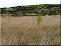
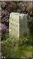
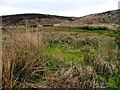
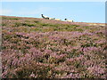
A boundary stone located just to the south* and west of a very swampy area which is one of the sources of Hardale Beck. The large boulder is the original Nan Stone and its western face is flat with a small cross etched into it. This stone has probably marked a boundary of one form or another since time immemorial**, though today it marks the boundary between the urban authorities of Redcar & Cleveland and Scarborough District. The more modern 18C? squared stone next to it has the name Nan Stone carved into its south face, though this is now fading. Both stones are about 1 metre high.
*Approaching from the north you will need to cross this swamp and whilst the OS map shows a clear trail coming from Sail Howe crossing the swamp to the west of the stone and going onto Black Dike Moor its not always clear where to actually cross, though there is usually a stick marking it, which you need to look out for. Regardless the crossing point is at NZ 74761 11294.
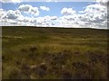
** Just a thought but I have a feeling that some of the older stones / boulders along the boundary line on Easington High Moor have been marking boundaries of one form or another for a very long time. There is no obvious reason for the boundary line it doesn’t follow ridges, becks etc, it is determined by the location of these stones / boulders with occasionally more modern 18C stones next to them.
You may be viewing yesterday's version of this page. To see the most up to date information please register for a free account.
")
")
")
Do not use the above information on other web sites or publications without permission of the contributor.
Nearby Images from Geograph Britain and Ireland:
©2006(licence)
©2023(licence)
©2006(licence)
©2016(licence)
©2022(licence)
The above images may not be of the site on this page, they are loaded from Geograph.
Please Submit an Image of this site or go out and take one for us!
Click here to see more info for this site
Nearby sites
Key: Red: member's photo, Blue: 3rd party photo, Yellow: other image, Green: no photo - please go there and take one, Grey: site destroyed
Download sites to:
KML (Google Earth)
GPX (GPS waypoints)
CSV (Garmin/Navman)
CSV (Excel)
To unlock full downloads you need to sign up as a Contributory Member. Otherwise downloads are limited to 50 sites.
Turn off the page maps and other distractions
Nearby sites listing. In the following links * = Image available
190m S 185° Good Goose Thorne (East)* Marker Stone (NZ7497011089)
471m SW 219° Long Stone (Black Dike Moor)* Marker Stone (NZ7469210909)
554m NNW 328° Sail Howe BSs* Marker Stone (NZ7467811742)
793m SW 225° Black Dike Moor Segmented Pit Alignment* Misc. Earthwork (NZ7443210707)
901m WSW 244° Long Stone (Easington High Moor)* Standing Stone (Menhir) (NZ7417710874)
1.3km WSW 239° Middle Rigg round barrows and pit alignment* Barrow Cemetery (NZ739106)
1.3km W 259° Franklan Dyke Stone* Marker Stone (NZ7371511006)
1.4km SSE 148° Temple Beeld (Lealholm Moor)* Stone Row / Alignment (NZ7572810141)
1.5km SW 227° Bella Dale Slack MS1* Marker Stone (NZ7392810262)
1.5km W 261° Little Dinnod* Marker Stone (NZ7350411024)
1.8km SSW 196° Brown Rigg (Lealholm Moor)* Round Barrow(s) (NZ7451709505)
1.9km SSW 198° Stump Cross (Lealholm Moor)* Ancient Cross (NZ7441109439)
2.1km W 270° Great Dinnod* Marker Stone (NZ7291511232)
2.1km SSE 169° Rawland Howe* Round Barrow(s) (NZ7542809261)
2.1km SSE 159° Lealholm Moor Round Barrow* Round Barrow(s) (NZ7575209348)
2.1km SSE 157° Lealholm Moor Ring Cairn* Ring Cairn (NZ7582909347)
2.1km W 280° Viscount Downe BS2* Marker Stone (NZ7288411618)
2.1km WNW 284° Waupley Moor South HC1* Ancient Village or Settlement (NZ7290111755)
2.1km WNW 282° Beckwith Stone* Marker Stone (NZ7287611705)
2.2km WNW 286° Black Howe (Waupley Moor)* Round Barrow(s) (NZ7289011853)
2.3km WSW 242° Nean Howe* Round Barrow(s) (NZ7299010184)
2.3km WNW 284° Waupley Moor South MS1* Marker Stone (NZ7273011793)
2.3km W 276° Old Beckwith Stone* Marker Stone (NZ7264311470)
2.4km SW 215° Danby Beacon* Round Barrow(s) (NZ73600927)
2.5km WNW 285° Water Dittins Marker Stone* Marker Stone (NZ7258311880)
View more nearby sites and additional images


 We would like to know more about this location. Please feel free to add a brief description and any relevant information in your own language.
 Wir möchten mehr über diese Stätte erfahren. Bitte zögern Sie nicht, eine kurze Beschreibung und relevante Informationen in Deutsch hinzuzufügen.
 Nous aimerions en savoir encore un peu sur les lieux. S'il vous plaît n'hesitez pas à ajouter une courte description et tous les renseignements pertinents dans votre propre langue.
 Quisieramos informarnos un poco más de las lugares. No dude en añadir una breve descripción y otros datos relevantes en su propio idioma.