


<< Our Photo Pages >> Danby Rigg Settlement - Ancient Village or Settlement in England in Yorkshire (North)
Submitted by vicky on Sunday, 21 July 2002 Page Views: 6821
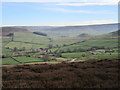
Multi-periodSite Name: Danby Rigg SettlementCountry: England County: Yorkshire (North) Type: Ancient Village or Settlement
Map Ref: NZ7059605768 Landranger Map Number: 94
Latitude: 54.442425N Longitude: 0.912958W
Condition:
| 5 | Perfect |
| 4 | Almost Perfect |
| 3 | Reasonable but with some damage |
| 2 | Ruined but still recognisable as an ancient site |
| 1 | Pretty much destroyed, possibly visible as crop marks |
| 0 | No data. |
| -1 | Completely destroyed |
| 5 | Superb |
| 4 | Good |
| 3 | Ordinary |
| 2 | Not Good |
| 1 | Awful |
| 0 | No data. |
| 5 | Can be driven to, probably with disabled access |
| 4 | Short walk on a footpath |
| 3 | Requiring a bit more of a walk |
| 2 | A long walk |
| 1 | In the middle of nowhere, a nightmare to find |
| 0 | No data. |
| 5 | co-ordinates taken by GPS or official recorded co-ordinates |
| 4 | co-ordinates scaled from a detailed map |
| 3 | co-ordinates scaled from a bad map |
| 2 | co-ordinates of the nearest village |
| 1 | co-ordinates of the nearest town |
| 0 | no data |
Be the first person to rate this site - see the 'Contribute!' box in the right hand menu.
Internal Links:
External Links:
I have visited· I would like to visit
Andy B has visited here
")
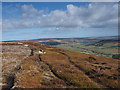
For more information about this site see Pastscape Monument No. 28854, which tells us: "Situated halfway between the two cross dykes on Danby Rigg there is an oval ring bank which was identified as a Bronze Age ring cairn and excavated by Atkinson in 1863. However it was excavated in 1956 by Lamplough, who found no evidence of the central pit recorded in the previous century. Instead it is now considered to be one of the enclosures of the Bronze Age field system which covers the rigg".
The monument is also scheduled as part of Historic England List ID 1018782 (Danby Rigg cairnfields, cross dykes, funerary monuments and associated features).
You may be viewing yesterday's version of this page. To see the most up to date information please register for a free account.
")
Do not use the above information on other web sites or publications without permission of the contributor.
Nearby Images from Geograph Britain and Ireland:
©2008(licence)
©2007(licence)
©2014(licence)
©2013(licence)
©2019(licence)
The above images may not be of the site on this page, they are loaded from Geograph.
Please Submit an Image of this site or go out and take one for us!
Click here to see more info for this site
Nearby sites
Key: Red: member's photo, Blue: 3rd party photo, Yellow: other image, Green: no photo - please go there and take one, Grey: site destroyed
Download sites to:
KML (Google Earth)
GPX (GPS waypoints)
CSV (Garmin/Navman)
CSV (Excel)
To unlock full downloads you need to sign up as a Contributory Member. Otherwise downloads are limited to 50 sites.
Turn off the page maps and other distractions
Nearby sites listing. In the following links * = Image available
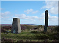
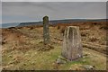
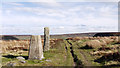
216m ENE 63° Danby Rigg (Slate Hill)* Marker Stone (NZ7078805869)
230m NE 44° Danby Rigg Marker Stones* Marker Stone (NZ7075305937)
329m NNE 12° Danby Rigg Cross Dyke (North End Farm Side)* Misc. Earthwork (NZ7065806091)
339m SSW 197° Danby Rigg Double Dyke* Misc. Earthwork (NZ7050305442)
395m NE 56° Danby Rigg Cross Dyke (Crossley Side)* Misc. Earthwork (NZ7092005996)
421m N 11° Segmented Pit Alignment (Ainthorpe / Danby Rigg)* Misc. Earthwork (NZ7066906183)
462m NE 52° Danby Rigg (Crossley Gate)* Cairn (NZ7095706058)
467m ENE 71° Old Wife's Stones (Danby Rigg)* Standing Stones (NZ7103705927)
492m NNE 15° Barrow Cemetery (Ainthorpe Rigg)* Barrow Cemetery (NZ7071906245)
542m NE 50° Danby Rigg Marker Stone (Crossley Gate)* Marker Stone (NZ7100606124)
562m NNE 22° Ring Cairns (Ainthorpe / Danby Rigg)* Ring Cairn (NZ7079906293)
817m NNE 15° Danby Rigg Cairn With Standing Stone* Ring Cairn (NZ70800656)
895m NNE 11° Black Nab Marker Stone (Ainthorpe / Danby Rigg)* Marker Stone (NZ7075806649)
993m SSW 210° Hanging Stone (Ainthorpe Rigg)* Natural Stone / Erratic / Other Natural Feature (NZ7011904896)
1.6km SSW 200° Dancing Stone (Botton)* Natural Stone / Erratic / Other Natural Feature (NZ7007604283)
2.5km WSW 246° Low Crag Dyke* Misc. Earthwork (NZ6833104727)
3.0km SW 234° High Stone Dike (Castleton Rigg)* Misc. Earthwork (NZ6820403990)
3.5km SE 128° Hart Leap Stones* Misc. Earthwork (NZ73380365)
3.7km SE 141° Rokan Stone* Marker Stone (NZ7298402936)
3.8km ESE 108° Black Hill Cross (Glaisdale Rigg)* Ancient Cross (NZ7425304643)
3.8km SE 128° Glaisdale Stone* Standing Stone (Menhir) (NZ7366603471)
3.9km SSW 194° Botton Cross* Ancient Cross (NZ6972402002)
3.9km E 98° Glaisdale Rigg (Hill Top)* Marker Stone (NZ7452605269)
4.1km ESE 123° Glaisdale Rigg Tall Cairn* Cairn (NZ7406403622)
4.1km NNE 27° Castleton Pits RB1* Round Barrow(s) (NZ7240009450)
View more nearby sites and additional images


 We would like to know more about this location. Please feel free to add a brief description and any relevant information in your own language.
 Wir möchten mehr über diese Stätte erfahren. Bitte zögern Sie nicht, eine kurze Beschreibung und relevante Informationen in Deutsch hinzuzufügen.
 Nous aimerions en savoir encore un peu sur les lieux. S'il vous plaît n'hesitez pas à ajouter une courte description et tous les renseignements pertinents dans votre propre langue.
 Quisieramos informarnos un poco más de las lugares. No dude en añadir una breve descripción y otros datos relevantes en su propio idioma.