<< Our Photo Pages >> Haw Rigg (Danby Low Moor) - Round Barrow(s) in England in Yorkshire (North)
Submitted by johndhunter on Thursday, 07 February 2019 Page Views: 733
Neolithic and Bronze AgeSite Name: Haw Rigg (Danby Low Moor)Country: England County: Yorkshire (North) Type: Round Barrow(s)
Nearest Village: Castleton
Map Ref: NZ6901910721
Latitude: 54.487146N Longitude: 0.936116W
Condition:
| 5 | Perfect |
| 4 | Almost Perfect |
| 3 | Reasonable but with some damage |
| 2 | Ruined but still recognisable as an ancient site |
| 1 | Pretty much destroyed, possibly visible as crop marks |
| 0 | No data. |
| -1 | Completely destroyed |
| 5 | Superb |
| 4 | Good |
| 3 | Ordinary |
| 2 | Not Good |
| 1 | Awful |
| 0 | No data. |
| 5 | Can be driven to, probably with disabled access |
| 4 | Short walk on a footpath |
| 3 | Requiring a bit more of a walk |
| 2 | A long walk |
| 1 | In the middle of nowhere, a nightmare to find |
| 0 | No data. |
| 5 | co-ordinates taken by GPS or official recorded co-ordinates |
| 4 | co-ordinates scaled from a detailed map |
| 3 | co-ordinates scaled from a bad map |
| 2 | co-ordinates of the nearest village |
| 1 | co-ordinates of the nearest town |
| 0 | no data |
Internal Links:
External Links:
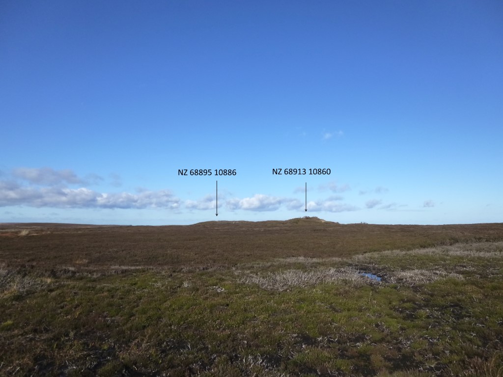
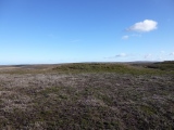
There are, or were 2 groups of barrows on Haw Rigg. A northern pair consisting of two barrows on the summit of Haw Rigg with one barrow at NZ 68895 10881 and the other 25m to the south of this at NZ 68913 10860. About 200m to the south of this pair were according to old OS maps published within the 1919 to 1958 time frame another group consisting of 3 barrows of which only one is now extant at NZ 69019 10721. The other two smaller barrows* being 50m east north east of this were at NZ 69052 10734 and NZ 69068 10742 (grid ref from old OS map), these are no longer visible. This southern group is recorded in Pastscape Monument 28453
* These two smaller barrows are considered to be the remains of a single barrow extensively excavated by J.C. Atkinson in 1861 or 1862, they were no longer visible after 1962.
The northern pair of barrows are Historic England List Entry Number 1018743 which has full details. It tells us that the most northerly barrow (NZ 68895 10881) is a flat topped mound 18m in diameter and 1.8m high which has at its northern end an east west excavation ditch. The other barrow (NZ 68913 10860) 25m to the south is slightly smaller at 14m in diameter with a height of 0.6m high at its north western margin rising to 1.2m on its eastern side. The top of the barrow is dished so that it is about 0.5m above ground level
Pastscape also has information on this northern pair of barrows at Monument 28450
The remaining southern barrow (NZ 69019 10721) about 200m to the south of the northern pair is List Entry Number 1016615 which has full details. It tells us that it is an earth and stone mound 12m in diameter and 0.6m high with a slightly dished top.
The now destroyed fourth barrow (shown as 2 small barrows on old OS Maps) excavated by Atkinson 50m ENE of the remaining southern barrow is described by Historic Englands list entries quoted above as as being somewhat less than 55 yards in diameter [should be circumference] (thus a maximum of 16m in diameter) and at least seven feet high (over 2m). It then goes on to describe quite an elaborate barrow as follows “It was constructed as a cairn of stones nine feet high built over a `card-house' of flat slabs built in a hole twelve feet (3.65m) in diameter. Over this internal cairn was piled stony earth containing four small cists, boxes formed with stone slabs, containing cremated bone and charcoal. On the south side of the barrow, near to the upper surface, was a pottery urn, also filled with cremated bone and charcoal, with fragments of a second urn found elsewhere within the mound.
Historic Englands source is I believe from an article by Atkinson in the January 1863 section of the Gentleman Magazine which can be read HERE The article is entitled “Traces of Our Remote Ancestors (second paper)” and runs from page 22 -26. He is never specific on where he is actually digging so it has to be deduced by those who know about these things from his descriptions (I myself being familiar with the area can just about make sense of it) Anyway his description of the excavation of the barrow on Haw Rigg (though he doesn’t name it) starts about 2/3 of the way down on page 24. Note: The barrow previously described on that page and which he uses as a reference point is Robin Hoods Butts 2 on this website. The description of this barrow of which there is a drawing at the top of page 24 can be confusing as it is described as being on Skelton Moors whilst it is on Gerrick Moor. Atkinson was Vicar of Danby so rarely calls those moors in what was the Skelton Parish by their correct name he just calls them the Skelton Moors and this is consistent throughout his writings. Anyway back to the excavation on Haw Rigg, again he does not specify which of the four barrows he is actually excavating, so I can only surmise that it has been deemed to be the one now destroyed (by his extensive excavation) mainly because its description does not pertain to any of the three surviving barrows.
Note: CBA Research Report 87 (Revised to 1990) Table 21 Page 98 quotes Urns & Sherds being found by Atkinson (1863) on Haw Rigg at NZ 690107. This six figure reference is the southern group
Points to Ponder (Anomalies):
1856 OS map shows 3 barrows on Haw Rigg in the same locations as the modern OS map
1862 – Atkinson purportedly excavated a barrow (not shown on the 1856 map) 50m ENE of the southern barrow.
1895 OS map now shows 4 barrows on Haw Rigg including the one excavated by Atkinson.
1919 to 1958 OS maps now show 5 barrows on the rigg. 2 smaller ones now replacing the one excavated by Atkinson
1962 – The two smaller barrows are now no longer visible and only 3 barrows on Haw Rigg are shown on subsequent OS maps
Note: The map reference NZ 69019 10721 given in the Site Page Heading is for the southern barrow.
You may be viewing yesterday's version of this page. To see the most up to date information please register for a free account.



Do not use the above information on other web sites or publications without permission of the contributor.
Click here to see more info for this site
Nearby sites
Key: Red: member's photo, Blue: 3rd party photo, Yellow: other image, Green: no photo - please go there and take one, Grey: site destroyed
Download sites to:
KML (Google Earth)
GPX (GPS waypoints)
CSV (Garmin/Navman)
CSV (Excel)
To unlock full downloads you need to sign up as a Contributory Member. Otherwise downloads are limited to 50 sites.
Turn off the page maps and other distractions
Nearby sites listing. In the following links * = Image available
536m WNW 301° Job Cross (Middle Heads)* Ancient Cross (NZ6855210987)
919m WSW 258° Three Howes Rigg (East)* Round Barrow(s) (NZ68121052)
1.0km WSW 245° Three Howes Rigg (West)* Round Barrow(s) (NZ68101027)
1.1km W 274° White Cross (Three Howes Rigg)* Marker Stone (NZ67931078)
1.2km SSW 198° Pike Howe (Three Howes Rigg)* Round Barrow(s) (NZ6864509546)
1.3km NNW 342° Moorsholm Moor Cup Marked Rock* Rock Art (NZ6861911919)
1.3km E 96° Siss Cross* Marker Stone (NZ7032510614)
1.7km WNW 291° Brown Hill RB1 (Moorsholm High Moor)* Round Barrow(s) (NZ6745511289)
1.8km ENE 63° Robin Hoods Butts 2* Round Barrow(s) (NZ70571155)
1.8km NE 55° Herd Howe (Gerrick Moor)* Round Barrow(s) (NZ7044611768)
1.8km NE 52° Gerrick Moor Enclosure E1* Ancient Village or Settlement (NZ7043711855)
1.8km NE 48° Gerrick Moor Hut Circles* Ancient Village or Settlement (NZ7037411965)
1.9km NE 54° Gerrick Moor RB1* Round Barrow(s) (NZ7052011834)
1.9km N 359° Freebrough Hill* Natural Stone / Erratic / Other Natural Feature (NZ68971263)
2.1km NW 309° Old Castle Hill* Stone Row / Alignment (NZ67391199)
2.1km ENE 71° Robin Hoods Butts 3* Round Barrow(s) (NZ7102411434)
2.2km ENE 66° Gerrick Moor Standing Stone SS1* Standing Stone (Menhir) (NZ7100111625)
2.2km WNW 298° Haredale Head BS1* Marker Stone (NZ6704511715)
2.3km ENE 74° Robin Hoods Butts 1* Round Barrow(s) (NZ71211140)
2.3km WNW 299° Tod Howe* Round Barrow(s) (NZ6694911814)
2.4km E 90° Elm Ledge RB1* Round Barrow(s) (NZ7144710745)
2.5km WNW 302° Quakers Causeway RB4* Round Barrow(s) (NZ6689911991)
2.5km ENE 75° Robin Hood Butts Howe* Round Barrow(s) (NZ71401140)
2.5km E 87° Elm Ledge LB1* Long Barrow (NZ7151110900)
2.8km WNW 297° Skelderskew Moor North East* Marker Stone (NZ6652011951)
View more nearby sites and additional images




 We would like to know more about this location. Please feel free to add a brief description and any relevant information in your own language.
 Wir möchten mehr über diese Stätte erfahren. Bitte zögern Sie nicht, eine kurze Beschreibung und relevante Informationen in Deutsch hinzuzufügen.
 Nous aimerions en savoir encore un peu sur les lieux. S'il vous plaît n'hesitez pas à ajouter une courte description et tous les renseignements pertinents dans votre propre langue.
 Quisieramos informarnos un poco más de las lugares. No dude en añadir una breve descripción y otros datos relevantes en su propio idioma.