


<< Our Photo Pages >> The Frith (Hampshire) - Hillfort in England in Hampshire
Submitted by ginger-tt on Tuesday, 20 October 2009 Page Views: 5144
Iron Age and Later PrehistorySite Name: The Frith (Hampshire)Country: England County: Hampshire Type: Hillfort
Nearest Town: Basingstoke
Map Ref: SU62686308
Latitude: 51.363337N Longitude: 1.101091W
Condition:
| 5 | Perfect |
| 4 | Almost Perfect |
| 3 | Reasonable but with some damage |
| 2 | Ruined but still recognisable as an ancient site |
| 1 | Pretty much destroyed, possibly visible as crop marks |
| 0 | No data. |
| -1 | Completely destroyed |
| 5 | Superb |
| 4 | Good |
| 3 | Ordinary |
| 2 | Not Good |
| 1 | Awful |
| 0 | No data. |
| 5 | Can be driven to, probably with disabled access |
| 4 | Short walk on a footpath |
| 3 | Requiring a bit more of a walk |
| 2 | A long walk |
| 1 | In the middle of nowhere, a nightmare to find |
| 0 | No data. |
| 5 | co-ordinates taken by GPS or official recorded co-ordinates |
| 4 | co-ordinates scaled from a detailed map |
| 3 | co-ordinates scaled from a bad map |
| 2 | co-ordinates of the nearest village |
| 1 | co-ordinates of the nearest town |
| 0 | no data |
Internal Links:
External Links:
I have visited· I would like to visit
SolarMegalith visited on 6th Aug 2010 - their rating: Cond: 3 Amb: 4 Access: 3
")
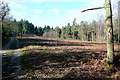
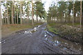
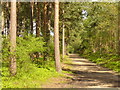
The Frith is a small univallate Iron Age hillfort to the north of Silchester Roman/Iron Age town. The single bank covers all sides apart from the south east and at the most is about 1.5 Meters high on the western edge. The ditch is also traceable for the length of the bank all be it at varying states.
You may be viewing yesterday's version of this page. To see the most up to date information please register for a free account.
 (PID:64024)")
 (PID:64023)")
Do not use the above information on other web sites or publications without permission of the contributor.
Nearby Images from Geograph Britain and Ireland:
©2011(licence)
©2015(licence)
©2010(licence)

©2010(licence)
©2010(licence)
The above images may not be of the site on this page, they are loaded from Geograph.
Please Submit an Image of this site or go out and take one for us!
Click here to see more info for this site
Nearby sites
Key: Red: member's photo, Blue: 3rd party photo, Yellow: other image, Green: no photo - please go there and take one, Grey: site destroyed
Download sites to:
KML (Google Earth)
GPX (GPS waypoints)
CSV (Garmin/Navman)
CSV (Excel)
To unlock full downloads you need to sign up as a Contributory Member. Otherwise downloads are limited to 50 sites.
Turn off the page maps and other distractions
Nearby sites listing. In the following links * = Image available
727m WSW 258° Aldermaston Enclosure* Misc. Earthwork (SU6197062917)
1.4km SE 126° Calleva Atrebatum* Ancient Village or Settlement (SU638623)
2.6km NE 41° Holden's Firs* Barrow Cemetery (SU64366506)
3.1km N 4° Raven Hill* Promontory Fort / Cliff Castle (SU62876615)
3.7km NNE 15° Ufton Nervet Bell Barrow* Round Barrow(s) (SU6356266625)
4.9km W 266° Borson Barrows* Barrow Cemetery (SU57756265)
6.1km N 354° Ufton Nervet Cursus Cursus (SU620691)
6.4km SE 138° Bullsdown Camp* Hillfort (SU67085838)
6.5km N 353° Ufton Nervet Cursus Cursus (SU618695)
6.7km SW 215° Ramsdell Modern Stone Circle* Modern Stone Circle etc (SU5891457590)
7.2km N 0° Englefield Cursus (SU626703)
7.3km NNE 20° Burghfield Cursus Cursus (SU65137000)
8.1km N 0° Englefield Cursus (SU626712)
9.8km NNW 346° St. Andrew's Well* Holy Well or Sacred Spring (SU602726)
10.3km NE 40° Anslow's Cottages Trackway Ancient Trackway (SU6923470984)
10.3km NE 48° Reading Cursus* Cursus (SU70307005)
10.4km S 188° Winklebury Camp (Hampshire)* Hillfort (SU613528)
10.9km WSW 237° Cottington's Hill Bowl Barrow* Round Barrow(s) (SU53615695)
11.5km WNW 297° Dunston Park Ancient Village or Settlement (SU523681)
11.9km WSW 239° Bowry Walls* Hillfort (SU52605676)
12.1km WNW 303° Ramsbury Corner* Hillfort (SU525696)
12.7km S 188° Basingstoke Cursus Cursus (SU611505)
12.7km SSE 150° Mapledurwell Bowl Barrow* Round Barrow(s) (SU691521)
12.7km NW 324° St. Frideswide's Well* Holy Well or Sacred Spring (SU54997326)
13.0km SSE 168° Hackwood Park Barrows* Round Barrow(s) (SU6543050410)
View more nearby sites and additional images


 We would like to know more about this location. Please feel free to add a brief description and any relevant information in your own language.
 Wir möchten mehr über diese Stätte erfahren. Bitte zögern Sie nicht, eine kurze Beschreibung und relevante Informationen in Deutsch hinzuzufügen.
 Nous aimerions en savoir encore un peu sur les lieux. S'il vous plaît n'hesitez pas à ajouter une courte description et tous les renseignements pertinents dans votre propre langue.
 Quisieramos informarnos un poco más de las lugares. No dude en añadir una breve descripción y otros datos relevantes en su propio idioma.