

<< Our Photo Pages >> Monument to a Horse - Modern Stone Circle etc in England in Hampshire
Submitted by JimChampion on Wednesday, 28 June 2006 Page Views: 14404
Modern SitesSite Name: Monument to a HorseCountry: England
NOTE: This site is 0.9 km away from the location you searched for.
County: Hampshire Type: Modern Stone Circle etc
Nearest Town: Southampton Nearest Village: Bramdean
Map Ref: SU62972716
Latitude: 51.040355N Longitude: 1.103218W
Condition:
| 5 | Perfect |
| 4 | Almost Perfect |
| 3 | Reasonable but with some damage |
| 2 | Ruined but still recognisable as an ancient site |
| 1 | Pretty much destroyed, possibly visible as crop marks |
| 0 | No data. |
| -1 | Completely destroyed |
| 5 | Superb |
| 4 | Good |
| 3 | Ordinary |
| 2 | Not Good |
| 1 | Awful |
| 0 | No data. |
| 5 | Can be driven to, probably with disabled access |
| 4 | Short walk on a footpath |
| 3 | Requiring a bit more of a walk |
| 2 | A long walk |
| 1 | In the middle of nowhere, a nightmare to find |
| 0 | No data. |
| 5 | co-ordinates taken by GPS or official recorded co-ordinates |
| 4 | co-ordinates scaled from a detailed map |
| 3 | co-ordinates scaled from a bad map |
| 2 | co-ordinates of the nearest village |
| 1 | co-ordinates of the nearest town |
| 0 | no data |
Internal Links:
External Links:
I have visited· I would like to visit
JimChampion has visited here
")
If either of these modern monuments marks the grave of Col. Greenwood's horse, it is most likely to be the mound of flints - also known as the "Pile of Stones". The mound, which looks something like a cairn or round barrow, is about 5 metres in diameter and over a metre high. It is now surrounded by beech trees, probably also planted by George Greenwood. He was responsible for planting the avenue of copper beeches that lead up from the Pile of Stones to Brockwood Park.
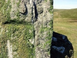
The stone circle on the other side of the road is about 8 metres in diameter and sits on an apron at road level that protrudes into the hollow way alongside the A272 road. It looks as if the circle originally had at least five sarsen tetralithons - each one consists of three partially buried stones pointing upwards with a capstone resting on top. Only the two tetralithons nearest the road are still intact; the others have fallen, some have been prised apart by young hazel trees. Local accounts say that Greenwood himself transported all the stones to the site in a wheelbarrow after being told by a doctor that he did not have long to live, but that he might prolong his life by exercise in the open air.
Local tradition tells various unlikely stories about the circle - that it is "as old as Stonehenge", and that it is the burial site of the many soldiers killed in the Civil War battle at nearby Cheriton in 1644. More recently the circle gets a mention in Pieter Boogaart's book "A272: an ode to a road".
The sarsens that make up the stone circle, none of which exceed 1.5m in length, were probably uncovered by the quarry workings a short distance to the east of the site. Greenwood had an interest in geology, as well as in unearthing archaeological sites in the neighbourhood. His grave at All Saints Church (Hinton Ampner) is marked with a single recumbent sarsen stone, simply inscribed "COLONEL GEORGE GREENWOOD B. 1799 D. 1875".
Access The Pile of Stones and Circle of Stones are alongside the A272 at a minor crossroads between Bramdean and the Meon Hut traffic light junction. There is some room to park on the verge, and a convenient bus stop if travelling by public transport. Be prepared to knock back a few nettles and brambles if you want to see the Circle of Stones in the summer.
References
- Website: Hampshire Treasures - Bramdean pages
- Jo Draper "Hampshire Curiosities" (The Dovecote Press, 1989)
- Pieter Boogaart "A272: an ode to a road" (Pallas Athene, 2004)
- Website: Krishnamurti Study Centre - Brockwood Park Buildings and Grounds
You may be viewing yesterday's version of this page. To see the most up to date information please register for a free account.
")
")
")
")
")
")
")
")
")
")
")
")
")
")
")
")
")
Do not use the above information on other web sites or publications without permission of the contributor.
Click here to see more info for this site
Nearby sites
Key: Red: member's photo, Blue: 3rd party photo, Yellow: other image, Green: no photo - please go there and take one, Grey: site destroyed
Download sites to:
KML (Google Earth)
GPX (GPS waypoints)
CSV (Garmin/Navman)
CSV (Excel)
To unlock full downloads you need to sign up as a Contributory Member. Otherwise downloads are limited to 50 sites.
Turn off the page maps and other distractions
Nearby sites listing. In the following links * = Image available
1.9km E 90° Pleasington Cemetery Bronze Age Cremation Site* Artificial Mound (SU649272)
3.7km W 281° Hinton Ampner tumuli* Round Barrow(s) (SU593278)
3.9km WNW 290° Cheriton Long Barrow* Long Barrow (SU5926328419)
5.3km SSW 207° Beacon Hill (Warnford)* Barrow Cemetery (SU606224)
6.7km S 171° Old Winchester Hill barrow cemetery* Barrow Cemetery (SU64062055)
6.7km S 171° Old Winchester Hill hillfort* Hillfort (SU64092053)
7.6km S 174° Stocks farm long barrow* Long Barrow (SU6380719581)
9.2km NE 53° East Tisted Bowl Barrow Round Barrow(s) (SU70263281)
9.6km SSW 195° Droxford Long Barrow (SU606179)
9.9km WSW 255° Longwood Barrow Long Barrow (SU534244)
10.1km NNW 334° Oliver's Battery* Ancient Village or Settlement (SU58413620)
10.3km NW 315° Itchen Stoke Down Barrows Round Barrow(s) (SU5554334384)
10.4km W 274° Cheesefoot Head Barrows* Barrow Cemetery (SU52572777)
10.9km W 276° Telegraph Hill Bowl Barrow* Round Barrow(s) (SU521281)
10.9km SE 126° Little Butser* Ancient Village or Settlement (SU719208)
11.0km SE 129° Butser Hill* Ancient Village or Settlement (SU716203)
11.2km W 261° Morestead Warren* Long Barrow (SU519253)
13.0km SSW 195° Holy Well (Swanmore)* Holy Well or Sacred Spring (SU597146)
13.1km W 280° Magdalen Hill Down* Barrow Cemetery (SU49992933)
13.3km ESE 111° Petersfield Heath Barrows* Barrow Cemetery (SU755225)
13.3km ESE 102° St. Mary's Well (Sheet)* Holy Well or Sacred Spring (SU761246)
13.4km NW 315° Micheldever Wood Banjo Enclosure* Ancient Village or Settlement (SU53353658)
13.7km NW 315° Micheldever Wood Bell Barrow* Round Barrow(s) (SU53213678)
13.8km W 273° The Dongas* Ancient Trackway (SU491276)
14.0km SE 141° Butser Ancient Farm* Museum (SU719164)
View more nearby sites and additional images


 We would like to know more about this location. Please feel free to add a brief description and any relevant information in your own language.
 Wir möchten mehr über diese Stätte erfahren. Bitte zögern Sie nicht, eine kurze Beschreibung und relevante Informationen in Deutsch hinzuzufügen.
 Nous aimerions en savoir encore un peu sur les lieux. S'il vous plaît n'hesitez pas à ajouter une courte description et tous les renseignements pertinents dans votre propre langue.
 Quisieramos informarnos un poco más de las lugares. No dude en añadir una breve descripción y otros datos relevantes en su propio idioma.