


<< Our Photo Pages >> Carr Ridge Cairn (Urra Moor) - Cairn in England in Yorkshire (North)
Submitted by johndhunter on Saturday, 07 December 2019 Page Views: 690
Neolithic and Bronze AgeSite Name: Carr Ridge Cairn (Urra Moor)Country: England
NOTE: This site is 0.4 km away from the location you searched for.
County: Yorkshire (North) Type: Cairn
Nearest Village: Chop Gate
Map Ref: NZ5859702283
Latitude: 54.412631N Longitude: 1.098635W
Condition:
| 5 | Perfect |
| 4 | Almost Perfect |
| 3 | Reasonable but with some damage |
| 2 | Ruined but still recognisable as an ancient site |
| 1 | Pretty much destroyed, possibly visible as crop marks |
| 0 | No data. |
| -1 | Completely destroyed |
| 5 | Superb |
| 4 | Good |
| 3 | Ordinary |
| 2 | Not Good |
| 1 | Awful |
| 0 | No data. |
| 5 | Can be driven to, probably with disabled access |
| 4 | Short walk on a footpath |
| 3 | Requiring a bit more of a walk |
| 2 | A long walk |
| 1 | In the middle of nowhere, a nightmare to find |
| 0 | No data. |
| 5 | co-ordinates taken by GPS or official recorded co-ordinates |
| 4 | co-ordinates scaled from a detailed map |
| 3 | co-ordinates scaled from a bad map |
| 2 | co-ordinates of the nearest village |
| 1 | co-ordinates of the nearest town |
| 0 | no data |
Internal Links:
External Links:
 (PID:205965)")
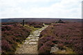
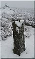
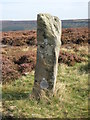
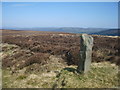
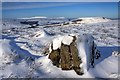
Located in a prominent position on Carr Ridge with good all round views. It is beside the Cleveland Way on its way up to Round Hill, the highest point on the NY Moors. It is not shown on modern OS maps but marked as a tumulus on older OS maps. It is Pastscape Monument 27408 which describes it as a denuded bronze age cairn visible as a slight ground swelling 5m in diameter and 0.3m in high. Though covered in deep heather I think it stands out a bit more than pastscapes description suggests, even though the eye does tend to be distracted to the walkers cairn built at its northerly edge.
You may be viewing yesterday's version of this page. To see the most up to date information please register for a free account.
 (PID:205964)")
 (PID:205963)")
 (PID:205962)")
 (PID:205961)")
Do not use the above information on other web sites or publications without permission of the contributor.
Nearby Images from Geograph Britain and Ireland:
©2014(licence)
©2017(licence)
©2020(licence)
©2010(licence)
©2009(licence)
The above images may not be of the site on this page, they are loaded from Geograph.
Please Submit an Image of this site or go out and take one for us!
Click here to see more info for this site
Nearby sites
Key: Red: member's photo, Blue: 3rd party photo, Yellow: other image, Green: no photo - please go there and take one, Grey: site destroyed
Download sites to:
KML (Google Earth)
GPX (GPS waypoints)
CSV (Garmin/Navman)
CSV (Excel)
To unlock full downloads you need to sign up as a Contributory Member. Otherwise downloads are limited to 50 sites.
Turn off the page maps and other distractions
Nearby sites listing. In the following links * = Image available
864m SE 143° Round Hill West* Cairn (NZ5913101602)
881m W 260° Cheshire Stone (Urra Moor)* Natural Stone / Erratic / Other Natural Feature (NZ5772902118)
1.1km SE 131° Round Hill East* Round Barrow(s) (NZ59430159)
1.2km S 169° North Gill Head (Urra Moor)* Rock Art (NZ5884101119)
1.4km SE 128° Face Stone (Urra Moor)* Standing Stone (Menhir) (NZ5968701442)
1.6km S 178° Collar Ridge Pillar Cairn* Cairn (NZ5866800700)
1.8km S 178° Collar Ridge Marker Stone* Marker Stone (NZ5868400435)
1.9km S 169° High Cable Stone (Tripsdale)* Natural Stone / Erratic / Other Natural Feature (NZ5896400446)
1.9km SW 215° Billy's Dyke* Misc. Earthwork (NZ5751300689)
2.0km S 173° Upper Tripsdale Earthwork* Misc. Earthwork (NZ5887500296)
2.1km S 176° Low Cable Stone (Tripsdale)* Natural Stone / Erratic / Other Natural Feature (NZ5878400147)
2.4km ENE 67° Burton Howe* Round Barrow(s) (NZ60790325)
2.4km ENE 65° Ingleby Greenhow Cairns* Round Cairn (NZ6078703333)
2.5km E 90° Jenny Bradley Cross* Ancient Cross (NZ6112502309)
2.6km SE 136° Badger Stone (Todd Intake Moor)* Natural Stone / Erratic / Other Natural Feature (NZ6044500423)
2.6km NE 44° Hand Stone (Ingleby Moor)* Marker Stone (NZ6041004222)
2.9km WNW 292° The Wainstones 6* Rock Art (NZ55840334)
3.0km WNW 296° The Wainstones* Rock Outcrop (NZ55880358)
3.0km SSE 154° Crook Staff Hill* Round Barrow(s) (SE5993599584)
3.1km SE 145° Bransdale Moor Stone Circle Stone Circle (SE604998)
3.1km WNW 297° The Wainstones 5* Rock Art (NZ5579303636)
3.1km ESE 107° Rudland Rigg Guide Stone GS2* Marker Stone (NZ6161301430)
3.2km WNW 291° The Wainstones 3* Rock Art (NZ5559203403)
3.2km WNW 295° Broughton Bank WAI 1a* Rock Art (NZ5562603590)
3.3km NNE 17° Mary Ross Seat* Carving (NZ5953405423)
View more nearby sites and additional images


 We would like to know more about this location. Please feel free to add a brief description and any relevant information in your own language.
 Wir möchten mehr über diese Stätte erfahren. Bitte zögern Sie nicht, eine kurze Beschreibung und relevante Informationen in Deutsch hinzuzufügen.
 Nous aimerions en savoir encore un peu sur les lieux. S'il vous plaît n'hesitez pas à ajouter une courte description et tous les renseignements pertinents dans votre propre langue.
 Quisieramos informarnos un poco más de las lugares. No dude en añadir una breve descripción y otros datos relevantes en su propio idioma.