


<< Our Photo Pages >> The Wainstones 5 - Rock Art in England in Yorkshire (North)
Submitted by SolarMegalith on Saturday, 05 August 2017 Page Views: 1219
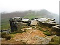
Rock ArtSite Name: The Wainstones 5Country: England County: Yorkshire (North) Type: Rock Art
Map Ref: NZ5579303636
Latitude: 54.425104N Longitude: 1.14158W
Condition:
| 5 | Perfect |
| 4 | Almost Perfect |
| 3 | Reasonable but with some damage |
| 2 | Ruined but still recognisable as an ancient site |
| 1 | Pretty much destroyed, possibly visible as crop marks |
| 0 | No data. |
| -1 | Completely destroyed |
| 5 | Superb |
| 4 | Good |
| 3 | Ordinary |
| 2 | Not Good |
| 1 | Awful |
| 0 | No data. |
| 5 | Can be driven to, probably with disabled access |
| 4 | Short walk on a footpath |
| 3 | Requiring a bit more of a walk |
| 2 | A long walk |
| 1 | In the middle of nowhere, a nightmare to find |
| 0 | No data. |
| 5 | co-ordinates taken by GPS or official recorded co-ordinates |
| 4 | co-ordinates scaled from a detailed map |
| 3 | co-ordinates scaled from a bad map |
| 2 | co-ordinates of the nearest village |
| 1 | co-ordinates of the nearest town |
| 0 | no data |
Internal Links:
External Links:
I have visited· I would like to visit
SolarMegalith visited on 28th Jul 2017 - their rating: Cond: 4 Amb: 4 Access: 3
")
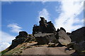
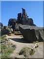
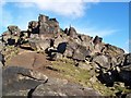
This large boulder is located among other boulders NW of The Wainstones and the Garfit Gap. Near its western edge there is a 2.3m long pecked groove running down the sloping surface.
Reference:
Brown, P. and Chappell, G. 2012. Prehistoric Rock Art in the North York Moors. Stroud: The History Press, p. 266 (as WAI 5).
You may be viewing yesterday's version of this page. To see the most up to date information please register for a free account.
")
")
Do not use the above information on other web sites or publications without permission of the contributor.
Nearby Images from Geograph Britain and Ireland:
©2009(licence)
©2010(licence)
©2010(licence)
©2009(licence)
©2010(licence)
The above images may not be of the site on this page, they are loaded from Geograph.
Please Submit an Image of this site or go out and take one for us!
Click here to see more info for this site
Nearby sites
Key: Red: member's photo, Blue: 3rd party photo, Yellow: other image, Green: no photo - please go there and take one, Grey: site destroyed
Download sites to:
KML (Google Earth)
GPX (GPS waypoints)
CSV (Garmin/Navman)
CSV (Excel)
To unlock full downloads you need to sign up as a Contributory Member. Otherwise downloads are limited to 50 sites.
Turn off the page maps and other distractions
Nearby sites listing. In the following links * = Image available
103m ESE 124° The Wainstones* Rock Outcrop (NZ55880358)
173m WSW 255° Broughton Bank WAI 1a* Rock Art (NZ5562603590)
299m S 172° The Wainstones 6* Rock Art (NZ55840334)
307m SW 221° The Wainstones 3* Rock Art (NZ5559203403)
1.3km W 261° Donna Cross* Ancient Cross (NZ5447503409)
1.9km SSW 199° Three Howes (Cold Moor)* Barrow Cemetery (NZ5520501823)
2.1km SSW 197° Cold Moor Bowl Barrow* Round Barrow(s) (NZ55220165)
2.1km WSW 252° Drake Howe* Round Barrow(s) (NZ53750295)
2.2km WSW 257° Cringle Moor* Round Barrow(s) (NZ5365703124)
2.5km SE 129° Cheshire Stone (Urra Moor)* Natural Stone / Erratic / Other Natural Feature (NZ5772902118)
3.1km ESE 117° Carr Ridge Cairn (Urra Moor)* Cairn (NZ5859702283)
3.3km W 264° Green Bank (Lord Stones Country Park)* Modern Stone Circle etc (NZ5253303268)
3.3km SSW 198° Cold Moor End (Raisdale)* Round Barrow(s) (NZ5479200470)
3.3km W 264° Hall Cliff Stone (Green Bank)* Marker Stone (NZ5247303234)
3.4km SSE 150° Billy's Dyke* Misc. Earthwork (NZ5751300689)
3.5km W 260° Lord Stones Cairn Circle.* Barrow Cemetery (NZ523030)
3.8km WSW 240° Three Thumb Stone (Bilsdale West Moor)* Standing Stone (Menhir) (NZ5250901691)
3.9km ESE 122° Round Hill West* Cairn (NZ5913101602)
3.9km SE 130° North Gill Head (Urra Moor)* Rock Art (NZ5884101119)
4.0km WSW 255° Carlton Bank Round Cairn (Howe Moor)* Round Cairn (NZ5193002585)
4.0km WSW 241° Stone Ruck (Bilsdale West Moor)* Round Barrow(s) (NZ5229701621)
4.1km WSW 253° Carlton Bank Iron Age Square Barrow* Misc. Earthwork (NZ5187202396)
4.1km SE 136° Collar Ridge Pillar Cairn* Cairn (NZ5866800700)
4.1km ENE 65° Mary Ross Seat* Carving (NZ5953405423)
4.2km ESE 120° Round Hill East* Round Barrow(s) (NZ59430159)
View more nearby sites and additional images


 We would like to know more about this location. Please feel free to add a brief description and any relevant information in your own language.
 Wir möchten mehr über diese Stätte erfahren. Bitte zögern Sie nicht, eine kurze Beschreibung und relevante Informationen in Deutsch hinzuzufügen.
 Nous aimerions en savoir encore un peu sur les lieux. S'il vous plaît n'hesitez pas à ajouter une courte description et tous les renseignements pertinents dans votre propre langue.
 Quisieramos informarnos un poco más de las lugares. No dude en añadir una breve descripción y otros datos relevantes en su propio idioma.