<< Our Photo Pages >> Churn Knob - Round Barrow(s) in England in Oxfordshire
Submitted by SolarMegalith on Sunday, 28 May 2006 Page Views: 15040
Neolithic and Bronze AgeSite Name: Churn KnobCountry: England County: Oxfordshire Type: Round Barrow(s)
Map Ref: SU522847 Landranger Map Number: 174
Latitude: 51.558774N Longitude: 1.248419W
Condition:
| 5 | Perfect |
| 4 | Almost Perfect |
| 3 | Reasonable but with some damage |
| 2 | Ruined but still recognisable as an ancient site |
| 1 | Pretty much destroyed, possibly visible as crop marks |
| 0 | No data. |
| -1 | Completely destroyed |
| 5 | Superb |
| 4 | Good |
| 3 | Ordinary |
| 2 | Not Good |
| 1 | Awful |
| 0 | No data. |
| 5 | Can be driven to, probably with disabled access |
| 4 | Short walk on a footpath |
| 3 | Requiring a bit more of a walk |
| 2 | A long walk |
| 1 | In the middle of nowhere, a nightmare to find |
| 0 | No data. |
| 5 | co-ordinates taken by GPS or official recorded co-ordinates |
| 4 | co-ordinates scaled from a detailed map |
| 3 | co-ordinates scaled from a bad map |
| 2 | co-ordinates of the nearest village |
| 1 | co-ordinates of the nearest town |
| 0 | no data |
Internal Links:
External Links:
I have visited· I would like to visit
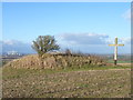
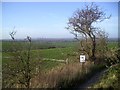
SolarMegalith visited on 18th Feb 2011 - their rating: Cond: 4 Amb: 4 Access: 3 The cross is currently lying near the Eastern side of the bell barrow.
")
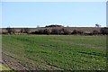
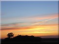
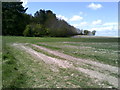
From SolarMegalith: Churn Knob round barrow is located on slope of the hill South from Blewbury and it's visible from the distance. It's a perfect example of a large bell barrow - it's 23 m wide and 1,5 m high. The site was excavated in 19th century.
During my visit on February 2011 the cross which was so controversial issue was lying on the ground near the Northern side of Churn Knob barrow.
Note: Clergyman told to move cross, see comment
You may be viewing yesterday's version of this page. To see the most up to date information please register for a free account.
")
")
")
Do not use the above information on other web sites or publications without permission of the contributor.
Nearby Images from Geograph Britain and Ireland:
©2012(licence)
©2007(licence)
©2006(licence)
©2013(licence)
©2014(licence)
The above images may not be of the site on this page, they are loaded from Geograph.
Please Submit an Image of this site or go out and take one for us!
Click here to see more info for this site
Nearby sites
Key: Red: member's photo, Blue: 3rd party photo, Yellow: other image, Green: no photo - please go there and take one, Grey: site destroyed
Download sites to:
KML (Google Earth)
GPX (GPS waypoints)
CSV (Garmin/Navman)
CSV (Excel)
To unlock full downloads you need to sign up as a Contributory Member. Otherwise downloads are limited to 50 sites.
Turn off the page maps and other distractions
Nearby sites listing. In the following links * = Image available
1.2km SW 216° Churn Farm East* Round Barrow(s) (SU515837)
1.4km S 189° The Warrior Barrows* Round Barrow(s) (SU520833)
1.7km WSW 245° Churn Farm West* Round Barrow(s) (SU5070483990)
2.2km SW 223° Fox Barrow* Round Barrow(s) (SU50718308)
2.9km ENE 60° Blewburton Hill* Hillfort (SU547862)
3.0km SE 144° Lowbury Hill Camp Ancient Temple (SU5400082250)
3.1km NW 304° Mount Skippet* Round Barrow(s) (SU496864)
6.1km ENE 58° Cholsey Hill Camp* Hillfort (SU5735387927)
6.1km ESE 109° Lingley Knob Round Barrow(s) (SU57978276)
6.1km ESE 109° Lingley Knoll Misc. Earthwork (SU58048274)
6.4km NNW 346° Great Western Park* Ancient Village or Settlement (SU50629091)
6.5km W 274° Skutchamer Knob* Round Barrow(s) (SU4565585038)
6.6km SSE 159° Grim's Ditch (Berkshire) Ancient Village or Settlement (SU546785)
6.8km S 182° Perborough Castle* Hillfort (SU520779)
7.4km ESE 103° Moulsford Cursus Cursus (SU59498312)
8.4km W 273° Grim's Ditch 2 (Oxfordshire) Misc. Earthwork (SU43768499)
8.8km E 85° Crowmarsh Cursus Cursus (SU60988560)
8.8km E 85° Crowmarsh Complex Barrow Cemetery (SU60998558)
9.0km NE 37° Brightwell Barrow* Round Barrow(s) (SU576919)
9.0km E 83° Crowmarsh Cursus Cursus (SU61158585)
9.1km NNE 32° Sinodun Camp* Hillfort (SU5694592434)
9.5km NNW 338° Drayton South Cursus Cursus (SU486935)
9.6km ESE 122° Goring Enclosure Causewayed Enclosure (SU604797)
9.7km W 267° Yew Down Round Barrow(s) (SU42528416)
9.7km ESE 121° Goring Cursus Cursus (SU606798)
View more nearby sites and additional images


 We would like to know more about this location. Please feel free to add a brief description and any relevant information in your own language.
 Wir möchten mehr über diese Stätte erfahren. Bitte zögern Sie nicht, eine kurze Beschreibung und relevante Informationen in Deutsch hinzuzufügen.
 Nous aimerions en savoir encore un peu sur les lieux. S'il vous plaît n'hesitez pas à ajouter une courte description et tous les renseignements pertinents dans votre propre langue.
 Quisieramos informarnos un poco más de las lugares. No dude en añadir una breve descripción y otros datos relevantes en su propio idioma.